(eds.) (2005). - Portal da Biodiversidade dos Açores - Universidade ...
(eds.) (2005). - Portal da Biodiversidade dos Açores - Universidade ...
(eds.) (2005). - Portal da Biodiversidade dos Açores - Universidade ...

Create successful ePaper yourself
Turn your PDF publications into a flip-book with our unique Google optimized e-Paper software.
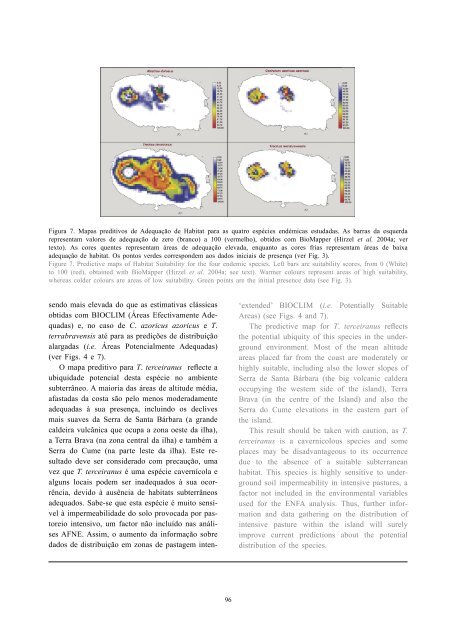
Figura 7. Mapas preditivos de Adequação de Habitat para as quatro espécies endémicas estu<strong>da</strong><strong>da</strong>s. As barras <strong>da</strong> esquer<strong>da</strong><br />
representam valores de adequação de zero (branco) a 100 (vermelho), obti<strong>dos</strong> com BioMapper (Hirzel et al. 2004a; ver<br />
texto). As cores quentes representam áreas de adequação eleva<strong>da</strong>, enquanto as cores frias representam áreas de baixa<br />
adequação de habitat. Os pontos verdes correspondem aos <strong>da</strong><strong>dos</strong> iniciais de presença (ver Fig. 3).<br />
Figure 7. Predictive maps of Habitat Suitability for the four endemic species. Left bars are suitability scores, from 0 (White)<br />
to 100 (red), obtained with BioMapper (Hirzel et al. 2004a; see text). Warmer colours represent areas of high suitability,<br />
whereas colder colours are areas of low suitability. Green points are the initial presence <strong>da</strong>ta (see Fig. 3).<br />
sendo mais eleva<strong>da</strong> do que as estimativas clássicas<br />
obti<strong>da</strong>s com BIOCLIM (Áreas Efectivamente Adequa<strong>da</strong>s)<br />
e, no caso de C. azoricus azoricus e T.<br />
terrabravensis até para as predições de distribuição<br />
alarga<strong>da</strong>s (i.e. Áreas Potencialmente Adequa<strong>da</strong>s)<br />
(ver Figs. 4 e 7).<br />
O mapa preditivo para T. terceiranus reflecte a<br />
ubiqui<strong>da</strong>de potencial desta espécie no ambiente<br />
subterrâneo. A maioria <strong>da</strong>s áreas de altitude média,<br />
afasta<strong>da</strong>s <strong>da</strong> costa são pelo menos modera<strong>da</strong>mente<br />
adequa<strong>da</strong>s à sua presença, incluindo os declives<br />
mais suaves <strong>da</strong> Serra de Santa Bárbara (a grande<br />
caldeira vulcânica que ocupa a zona oeste <strong>da</strong> ilha),<br />
a Terra Brava (na zona central <strong>da</strong> ilha) e também a<br />
Serra do Cume (na parte leste <strong>da</strong> ilha). Este resultado<br />
deve ser considerado com precaução, uma<br />
vez que T. terceiranus é uma espécie cavernícola e<br />
alguns locais podem ser inadequa<strong>dos</strong> à sua ocorrência,<br />
devido à ausência de habitats subterrâneos<br />
adequa<strong>dos</strong>. Sabe-se que esta espécie é muito sensível<br />
à impermeabili<strong>da</strong>de do solo provoca<strong>da</strong> por pastoreio<br />
intensivo, um factor não incluído nas análises<br />
AFNE. Assim, o aumento <strong>da</strong> informação sobre<br />
<strong>da</strong><strong>dos</strong> de distribuição em zonas de pastagem inten-<br />
96<br />
‘extended’ BIOCLIM (i.e. Potentially Suitable<br />
Areas) (see Figs. 4 and 7).<br />
The predictive map for T. terceiranus reflects<br />
the potential ubiquity of this species in the underground<br />
environment. Most of the mean altitude<br />
areas placed far from the coast are moderately or<br />
highly suitable, including also the lower slopes of<br />
Serra de Santa Bárbara (the big volcanic caldera<br />
occupying the western side of the island), Terra<br />
Brava (in the centre of the Island) and also the<br />
Serra do Cume elevations in the eastern part of<br />
the island.<br />
This result should be taken with caution, as T.<br />
terceiranus is a cavernicolous species and some<br />
places may be disadvantageous to its occurrence<br />
due to the absence of a suitable subterranean<br />
habitat. This species is highly sensitive to underground<br />
soil impermeability in intensive pastures, a<br />
factor not included in the environmental variables<br />
used for the ENFA analysis. Thus, further information<br />
and <strong>da</strong>ta gathering on the distribution of<br />
intensive pasture within the island will surely<br />
improve current predictions about the potential<br />
distribution of the species.