Käyttöohje Bruksanvisning Instruction Manual FI SE EN
Käyttöohje Bruksanvisning Instruction Manual FI SE EN
Käyttöohje Bruksanvisning Instruction Manual FI SE EN

Create successful ePaper yourself
Turn your PDF publications into a flip-book with our unique Google optimized e-Paper software.
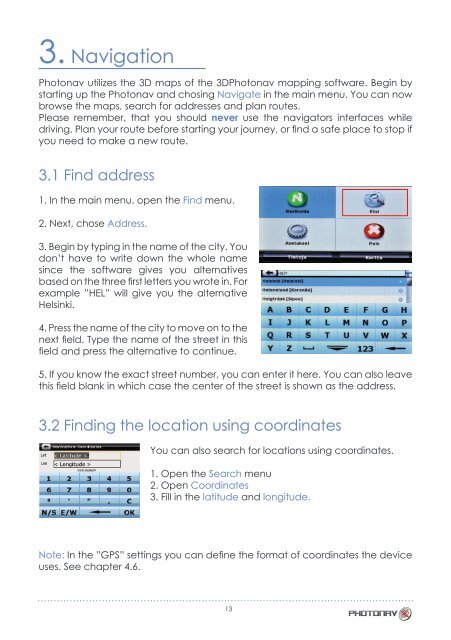
3. Navigation<br />
Photonav utilizes the 3D maps of the 3DPhotonav mapping software. Begin by<br />
starting up the Photonav and chosing Navigate in the main menu. You can now<br />
browse the maps, search for addresses and plan routes.<br />
Please remember, that you should never use the navigators interfaces while<br />
driving. Plan your route before starting your journey, or find a safe place to stop if<br />
you need to make a new route.<br />
3.1 Find address<br />
1. In the main menu, open the Find menu.<br />
2. Next, chose Address.<br />
3. Begin by typing in the name of the city. You<br />
don’t have to write down the whole name<br />
since the software gives you alternatives<br />
based on the three first letters you wrote in. For<br />
example ”HEL” will give you the alternative<br />
Helsinki.<br />
4. Press the name of the city to move on to the<br />
next field. Type the name of the street in this<br />
field and press the alternative to continue.<br />
5. If you know the exact street number, you can enter it here. You can also leave<br />
this field blank in which case the center of the street is shown as the address.<br />
3.2 Finding the location using coordinates<br />
You can also search for locations using coordinates.<br />
1. Open the Search menu<br />
2. Open Coordinates<br />
3. Fill in the latitude and longitude.<br />
Note: In the ”GPS” settings you can define the format of coordinates the device<br />
uses. See chapter 4.6.<br />
13