Ausgabe 03 / 2005 - Schüco
Ausgabe 03 / 2005 - Schüco
Ausgabe 03 / 2005 - Schüco
- TAGS
- www.schueco.com

Erfolgreiche ePaper selbst erstellen
Machen Sie aus Ihren PDF Publikationen ein blätterbares Flipbook mit unserer einzigartigen Google optimierten e-Paper Software.
Der bisherige Regionalbahnhof WTC wird zum<br />
ICE-Bahnhof und damit zu einem wichtigen<br />
Verkehrsknotenpunkt ausgebaut. Sowohl den<br />
Bahnhof als auch die Autobahn wollte man<br />
zunächst komplett unter die Erde verlegen, um<br />
die bisherige Zweiteilung des Gebiets durch<br />
Damm und Gleise aufzuheben. Gleichzeitig<br />
dürfte aber auch der Gewinn an kostbarem<br />
Baugrund eine Rolle gespielt haben. Seit<br />
jedoch auch in den Niederlanden zunehmend<br />
Büroraum leersteht, ist ein kostengünstigeres<br />
"Deichmodell" im Gespräch, bei dem die<br />
Verkehrswege nur stellenweise überbaut werden.<br />
Der Masterplan Zuidas ist ein Entwicklungsmodell,<br />
dessen zehn Teilgebiete in drei<br />
Phasen bis zum Jahr 2025 realisiert werden.<br />
Den Anfang machte das Gebiet rund um das<br />
bestehende World Trade Center, das dieses<br />
Jahr fertig gestellt wurde und von recht kommerzieller<br />
Hochhausarchitektur bestimmt<br />
wird. Im Gegensatz dazu verspricht das auf<br />
der anderen Seite der Autobahn gelegene<br />
Gebiet Mahler 4, das sich derzeit im Bau befindet,<br />
sowohl in städtebaulicher als auch in<br />
architektonischer Hinsicht eine gelungene<br />
Synthese aus Markttauglichkeit und Innovation<br />
zu werden.<br />
Branimir Medić und Pero Puljiz, zwei kroatische<br />
Architekten, die – ebenso wie Pi de<br />
Bruijn – Partner im Büro de Architekten Cie. in<br />
Amsterdam sind, waren für die städtebauliche<br />
Umsetzung von Mahler 4 verantwortlich. Mit<br />
ihrem Masterplan geben sie dem Gebiet ein<br />
einheitliches, skulpturales und städtebauliches<br />
Bild, das aber auch Raum für die individuelle<br />
Ästhetik der Gebäude lässt.<br />
Zwei von Nord nach Süd verlaufende Straßen<br />
unterteilen das Projektgebiet in drei Abschnitte<br />
und bilden die Verbindung zwischen<br />
dem Stadtteil Oud-Zuid im Norden und<br />
Buitenveldert, einer südlich des Autobahnrings<br />
gelegenen Stadterweiterung aus der<br />
The WTC station, previously only served by<br />
regional trains, will become an intercity station<br />
and an important transport link. The plan<br />
was to put both the railway and motorway<br />
fully underground and dispense with the<br />
long-standing division of the area by the dyke<br />
and railway tracks. This would also lead to<br />
significant gains in terms of valuable building<br />
space. However, with an ever-greater number<br />
of offices standing empty in the Netherlands<br />
as well as elsewhere, a more economical<br />
“dyke model” is under discussion, which<br />
would involve building over roads only in<br />
certain places.<br />
The Zuidas project is a development model<br />
covering ten areas which should be<br />
implemented in three stages and completed<br />
by 2025. The first area is centred around<br />
the existing World Trade Centre which was<br />
completed this year and is characterised by<br />
typical commercial high-rise architecture.<br />
By way of contrast, the Mahler 4 area on<br />
the other side of the motorway, which is<br />
now under construction, looks set to become<br />
a successful synthesis of market appeal<br />
and innovation, both in terms of urban<br />
development and architecture.<br />
Two Croatian architects, Branimir Medić and<br />
Pero Puljiz – both based in Amsterdam like Pi<br />
de Bruijn – were responsible for the Mahler 4<br />
urban development project. Their design<br />
gives the area a harmonious, sculptured and<br />
urban image, but nevertheless leaves room<br />
for individuality in building design.<br />
Two roads running from north to south divide<br />
the development area into three sections and<br />
create a link between the Oud-Zuid area to the<br />
north and Buitenveldert, an area south of the<br />
ring road built during the post-war expansion<br />
Fotos (Portrait): Paul Huf, Amsterdam<br />
Renderings/Images: CIIID/Cees van Giessen, Amsterdam<br />
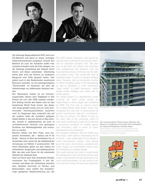
Drei unterschiedliche Höhenniveaus definieren den<br />
Bezug zur Umgebung und machen das Projektgebiet<br />
als zusammenhängenden Komplex lesbar<br />
Three different levels define the relationship with<br />
the surroundings and make the development area<br />
intelligible as a coherent complex<br />
<strong>03</strong> 67