

Hydro-‐political Baseline of the Upper Jordan River - Ibrahim Abd El Al
Hydro-‐political Baseline of the Upper Jordan River - Ibrahim Abd El Al
Hydro-‐political Baseline of the Upper Jordan River - Ibrahim Abd El Al

You also want an ePaper? Increase the reach of your titles
YUMPU automatically turns print PDFs into web optimized ePapers that Google loves.
echarge from <strong>the</strong> Easter Lower Galilee), however, and so to be <strong>of</strong> relevance to this study,<br />
must be ‘unpacked’.<br />
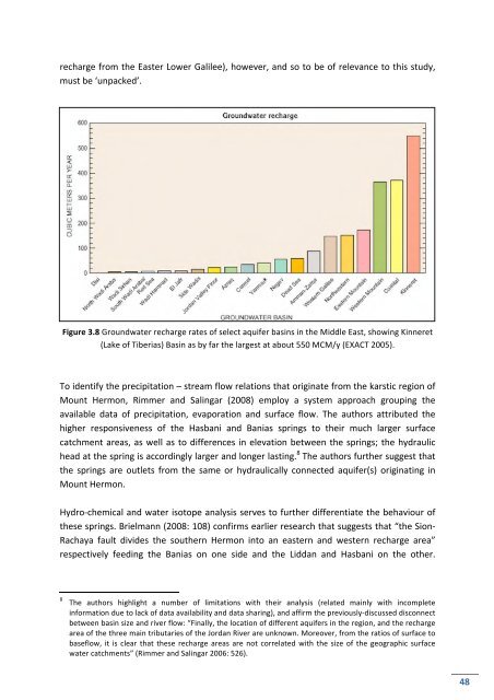
Figure 3.8 Groundwater recharge rates <strong>of</strong> select aquifer basins in <strong>the</strong> Middle East, showing Kinneret<br />
(Lake <strong>of</strong> Tiberias) Basin as by far <strong>the</strong> largest at about 550 MCM/y (EXACT 2005).<br />
To identify <strong>the</strong> precipitation – stream flow relations that originate from <strong>the</strong> karstic region <strong>of</strong><br />
Mount Hermon, Rimmer and Salingar (2008) employ a system approach grouping <strong>the</strong><br />
available data <strong>of</strong> precipitation, evaporation and surface flow. The authors attributed <strong>the</strong><br />
higher responsiveness <strong>of</strong> <strong>the</strong> Hasbani and Banias springs to <strong>the</strong>ir much larger surface<br />
catchment areas, as well as to differences in elevation between <strong>the</strong> springs; <strong>the</strong> hydraulic<br />
head at <strong>the</strong> spring is accordingly larger and longer lasting. 8 The authors fur<strong>the</strong>r suggest that<br />
<strong>the</strong> springs are outlets from <strong>the</strong> same or hydraulically connected aquifer(s) originating in<br />
Mount Hermon.<br />
<strong>Hydro</strong>-‐chemical and water isotope analysis serves to fur<strong>the</strong>r differentiate <strong>the</strong> behaviour <strong>of</strong><br />
<strong>the</strong>se springs. Brielmann (2008: 108) confirms earlier research that suggests that “<strong>the</strong> Sion-‐<br />
Rachaya fault divides <strong>the</strong> sou<strong>the</strong>rn Hermon into an eastern and western recharge area”<br />
respectively feeding <strong>the</strong> Banias on one side and <strong>the</strong> Liddan and Hasbani on <strong>the</strong> o<strong>the</strong>r.<br />
8 The authors highlight a number <strong>of</strong> limitations with <strong>the</strong>ir analysis (related mainly with incomplete<br />
information due to lack <strong>of</strong> data availability and data sharing), and affirm <strong>the</strong> previously-‐discussed disconnect<br />
between basin size and river flow: “Finally, <strong>the</strong> location <strong>of</strong> different aquifers in <strong>the</strong> region, and <strong>the</strong> recharge<br />
area <strong>of</strong> <strong>the</strong> three main tributaries <strong>of</strong> <strong>the</strong> <strong>Jordan</strong> <strong>River</strong> are unknown. Moreover, from <strong>the</strong> ratios <strong>of</strong> surface to<br />
baseflow, it is clear that <strong>the</strong>se recharge areas are not correlated with <strong>the</strong> size <strong>of</strong> <strong>the</strong> geographic surface<br />
water catchments” (Rimmer and Salingar 2006: 526).<br />
48