The Biodiversity of Bac Huong Hoa Nature Reserve - Birdlife ...
The Biodiversity of Bac Huong Hoa Nature Reserve - Birdlife ...
The Biodiversity of Bac Huong Hoa Nature Reserve - Birdlife ...

You also want an ePaper? Increase the reach of your titles
YUMPU automatically turns print PDFs into web optimized ePapers that Google loves.
lowlands have been almost entirely deforested since 1945, and the forest in the foothills is now<br />
highly fragmented and degraded, with few substantial areas <strong>of</strong> good quality forest remaining<br />
(Statterfield et al. 1998).<br />
<strong>The</strong> EBA was defined by the ranges <strong>of</strong> nine species, although <strong>of</strong> these, one is now considered a<br />
hybrid taxon (Imperial Pheasant Lophura imperialis) and another (Annam Partridge Arborophila<br />
merlini), is now regarded by BirdLife International as a subspecies <strong>of</strong> the more widespread<br />
Chestnut-necklaced Partridge Arborophila chaltonii. Of the remaining seven species, the range <strong>of</strong><br />
Crested Argus Reinardia ocellata also extends upwards into montane forest, and White-cheeked<br />
Laughingthrush Garrulax vassali is principally a lower montane species <strong>of</strong> only marginal<br />
occurrence in this EBA. Sooty Babbler Stachyris herberti is a localised species with a distribution<br />
confined to forest on limestone outcrops. <strong>The</strong> Annamese Lowlands also support a number <strong>of</strong><br />
widespread Near Threatened species, such as Red-collared Woodpecker Picus rabieri and<br />
Blyth’s Kingfisher Alcedo hercules.<br />
Deforestation in this EBA has been intense; the only remaining good quality lowland forest is in<br />
small valleys and on the lower slopes <strong>of</strong> the hills. Causes <strong>of</strong> deforestation in the past include<br />
clearance for agriculture to feed a rapidly increasing population, warfare and logging. <strong>The</strong><br />
remaining forests are subject to commercial logging, further clearance for permanent agriculture<br />
and settlements and degradation as a result <strong>of</strong> fuelwood collection, shifting agriculture and fire<br />
(Collins et al. 1991, Eames et al. 1992).<br />
<strong>The</strong>re are 13 protected areas in the Annamese Lowlands EBA in Vietnam, which protect blocks<br />
<strong>of</strong> forest along the eastern edge <strong>of</strong> the Annamite Range and the coastal lowlands. Approximately<br />
50 kilometres to the south <strong>of</strong> <strong>Bac</strong> <strong>Huong</strong> <strong>Hoa</strong> are the Dakrong and Phong Dien nature reserves,<br />
which support 40,526 and 41,548 hectares respectively. Nearly 70 kilometres to the north, Phong<br />
Nha Ke Bang protects 85,745 hectares <strong>of</strong> lowland broad-leaf evergreen and limestone karst<br />
forest. Together with adjacent forest in Quang Binh Province, the forests <strong>of</strong> <strong>Bac</strong> <strong>Huong</strong> <strong>Hoa</strong><br />
constituted the largest area <strong>of</strong> unprotected lowland evergreen forest in the Central Annamites<br />
Landscape. As such, its addition to the protected area network represents an important<br />
contribution to conservation in the region.<br />
2. Characteristics <strong>of</strong> <strong>Bac</strong> <strong>Huong</strong> <strong>Hoa</strong> <strong>Nature</strong> <strong>Reserve</strong><br />
2.1 Location<br />
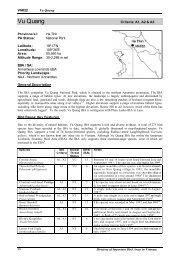
<strong>Bac</strong> <strong>Huong</strong> <strong>Hoa</strong> <strong>Nature</strong> <strong>Reserve</strong> encompasses an area <strong>of</strong> lowland and mid-montane evergreen<br />
forest in central Vietnam, adjacent to the international border with Laos (Map 1.). It covers<br />
25,200 hectares, including 20,646.2 hectares <strong>of</strong> natural forest. It is located in the north <strong>of</strong> <strong>Huong</strong><br />
<strong>Hoa</strong> District, Quang Tri Province, 50 km north-west <strong>of</strong> Khe San town, and 120 km west <strong>of</strong> Dong<br />
Hai town. <strong>The</strong> nature reserve is bisected by the Ho Chi Minh Highway. It encompasses the<br />
territory <strong>of</strong> five communes, namely <strong>Huong</strong> Linh, <strong>Huong</strong> Son, <strong>Huong</strong> Phung, <strong>Huong</strong> Viet and<br />
<strong>Huong</strong> Lap (Map 2). To the north, it is bordered by Quang Binh Province and to the east it is<br />
bordered by three districts, Vinh Linh, Gio Linh and Dakrong. <strong>The</strong> nature reserve is bounded by<br />
the coordinates 16043'22’’ to 16059'55’’ N and 106033'00’’ to 106047'03’’E. Within the<br />
boundary <strong>of</strong> BHH NR, there are two villages with c. 30 households, <strong>of</strong> which 12 households<br />
10