appian way conservation area - Burwood Council
appian way conservation area - Burwood Council
appian way conservation area - Burwood Council

Create successful ePaper yourself
Turn your PDF publications into a flip-book with our unique Google optimized e-Paper software.
1.1 Description of the Conservation Area<br />
<strong>Burwood</strong> Consolidated DCP Pt 4 - Appian Way Conservation Area<br />
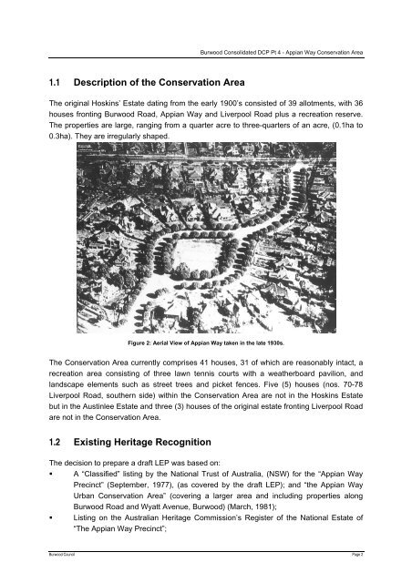
The original Hoskins’ Estate dating from the early 1900’s consisted of 39 allotments, with 36<br />
houses fronting <strong>Burwood</strong> Road, Appian Way and Liverpool Road plus a recreation reserve.<br />
The properties are large, ranging from a quarter acre to three-quarters of an acre, (0.1ha to<br />
0.3ha). They are irregularly shaped.<br />
Figure 2: Aerial View of Appian Way taken in the late 1930s.<br />
The Conservation Area currently comprises 41 houses, 31 of which are reasonably intact, a<br />
recreation <strong>area</strong> consisting of three lawn tennis courts with a weatherboard pavilion, and<br />
landscape elements such as street trees and picket fences. Five (5) houses (nos. 70-78<br />
Liverpool Road, southern side) within the Conservation Area are not in the Hoskins Estate<br />
but in the Austinlee Estate and three (3) houses of the original estate fronting Liverpool Road<br />
are not in the Conservation Area.<br />
1.2 Existing Heritage Recognition<br />
The decision to prepare a draft LEP was based on:<br />
A “Classified” listing by the National Trust of Australia, (NSW) for the “Appian Way<br />
Precinct” (September, 1977), (as covered by the draft LEP); and “the Appian Way<br />
Urban Conservation Area” (covering a larger <strong>area</strong> and including properties along<br />
<strong>Burwood</strong> Road and Wyatt Avenue, <strong>Burwood</strong>) (March, 1981);<br />
Listing on the Australian Heritage Commission’s Register of the National Estate of<br />
“The Appian Way Precinct”;<br />
<strong>Burwood</strong> <strong>Council</strong> Page 2