

here - Ashley Baynton-Williams
here - Ashley Baynton-Williams
here - Ashley Baynton-Williams

You also want an ePaper? Increase the reach of your titles
YUMPU automatically turns print PDFs into web optimized ePapers that Google loves.
THE WOODEN WALLS<br />
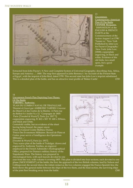
13<br />
Uncommon<br />
Contemporary American<br />
Plan Of The Battle<br />
TANNER, Benjamin.<br />
'DISPOSITION of the<br />
ENGLISH & FRENCH<br />
FLEETS at the<br />
Commencement of the<br />
Action August 1.st 1798.'<br />
'Tanner sc.' 'New York<br />
Published by John Low<br />
for Payne's Geography.'<br />
New York: John Low,<br />
[1800]; copperplate<br />
engraving, in black and<br />
white. Evidence of the<br />
old folds, two small<br />
spots, but a good<br />
example.<br />
Extracted from John Payne's 'A New and Complete System of Universal Geography; describing Asia, Africa,<br />
Europe and America ...', 1800. The map first appeared in John Remney's 'An Account of the Present State<br />
of Egypt', with the imprint of John Reid, dated 1799. This second state has John Low's imprint substituted.<br />
This is a detailed plan of the battle, and has an attractive inset profile of 'Bokier Castle'. £350<br />
14<br />
Uncommon French Plan Depicting Four Phases<br />
Of The Battle<br />
TARDIEU, Ambroise.<br />
'PLAN DU COMBAT NAVAL DE TRAFALGAR.'<br />
'Dessiné et Gravé par AMBROISE TARDIEU Graveur<br />
du Dépot G.d des Cartes de la Marine. A Paris rue<br />
du Battoir S.t André N.o 12.' 'Campagne de 1805.'<br />
Paris: [Treuttel & Wurtz?], Paris, [ca. 1817 ?];<br />
copperplate engraving, B: 462 x 369 W: 468 x 369mm,<br />
and black and white.<br />
Centrefold visible, but no evidence of the sheet<br />
having being bound, the paper uncut.<br />
From: le General Comte Mathieu Dumas<br />
'Précis Des Evenemens Militaires. Receuil de Plans et<br />
Cartes, pour servir a l'intelligence des Opérations<br />
Militaires ...'<br />
[Treuttel & Wurtz?], Paris [ca. 1817].<br />
Very scarce plan of the battle of Trafalgar, drawn and<br />
engraved by Ambroise Tardieu, an engraver<br />
employed in the French Admiralty's Hydrographical<br />
Office, prepared for Dumas's military history of the<br />
Napoleonic Wars. The history was prepared in<br />
chronological form, with each fascicle devoted to one<br />
year from the war, with volume 6 covering 1805. This plan is divided into four sections, each devoted to one<br />
phase ('MOUVEMENT') of the battle, the first, the approach of the two British columns, lead by Nelson and<br />
Collingwood; the second shows the initial contact as the two columns engaged the Franco-Spanish line; the<br />
third shows the general melée between the ships of the two fleets, and the final section, the surviving ships<br />
of the joint fleet breaking away from the battle. £300<br />
18