

here - Ashley Baynton-Williams
here - Ashley Baynton-Williams
here - Ashley Baynton-Williams

You also want an ePaper? Increase the reach of your titles
YUMPU automatically turns print PDFs into web optimized ePapers that Google loves.
SCOTLAND<br />
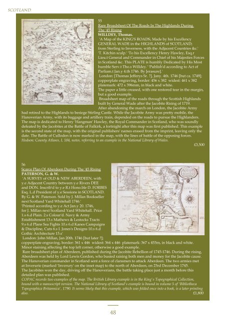
55<br />
Rare Broadsheet Of The Roads In The Highlands During<br />
The '45 Rising<br />
WILLDEY, Thomas.<br />
'A Map of the KING'S ROADS, Made by his Excellency<br />
GENERAL WADE in the HIGHLANDS of SCOTLAND;<br />
from Sterling to Inverness, with the Adjacent Countries &c.'<br />
'T. Kitchin sculp.' 'To his Excellency Henry Hawley, Esq.r<br />
Lieu.t General and Commander in Chief of his Majesties Forces<br />
in Scotland &c. This PLATE is humbly Dedicated by His Most<br />
humble Serv.t Tho.s Willdey.' 'Publish'd according to Act of<br />
Parliam.t Jan.y 4.th 1746. By [erasure].'<br />
London: [Thomas Jefferys Sr. ?], Jany. 4th. 1746 [but ca. 1749];<br />
copperplate engraving, border: 456 x 382 widest: 461 x 382<br />
platemark: 472 x 396mm, in black and white.<br />
The paper a little creased, with one restored tear in the margin,<br />
but a good example.<br />
Broadsheet map of the roads through the Scottish Highlands<br />
built by General Wade after the Jacobite Rising of 1719.<br />
After abandoning the march on London, the Jacobite Army<br />
had retired to the Highlands to besiege Stirling Castle. While the Jacobite Army was pretty mobile, the<br />
Hanoverian Army, with its baggage and artillery train, depended on the roads to pursue the Highlanders.<br />
The map is dedicated to Henry 'Hangman' Hawley, the Royal Commander in Scotland, who was soundly<br />
defeated by the Jacobites at the Battle of Falkirk, a fortnight after this map was first published. This example<br />
is the second state of the map, with the original publishers' names erased from the imprint, leaving only the<br />
date. The Battle of Culloden is now marked in the map, with the lines of battle of the opposing forces.<br />
Hodson: County Atlases, I, 184, notes, referring to an example in the National Library of Wales.<br />
£3,500<br />
56<br />
Scarce Plan Of Aberdeen During The '45 Rising<br />
PATERSON, G. & W.<br />
'A SURVEY of OLD & NEW ABERDEEN, with<br />
y.e Adjacent Country between y.e Rivers DEE<br />
and DON. Inscrib'd to y.e R.t Hono.ble D. FORBES<br />
Esq. L.d President of y.e Sessions in SCOTLAND.<br />
By G. & W. Paterson. Sold by J. Millan Bookseller<br />
next Scotland Yard Whitehall 1746.'<br />
'Printed according to y.e Act Jan.y 20. 1746,<br />
for J. Millan next Scotland Yard Whitehall. Price<br />
1.s 6.d Plain. 2.s Colour'd. Navy & Army<br />
Establishment 13.s Mathews & Lestocks Tracts<br />
9.s 6.d Plans Sea Fights 10.s 6.d Kanes Campaigns<br />
& Discipline, Cuts 6.s I. Jones's Designs 10.s 6.d<br />
Gothic Architecture 15.s'<br />
London: John Millan, Jan 20th. 1746 [but later ?];<br />
copperplate engraving, border: 361 x 446 widest: 364 x 446 platemark: 367 x 453m, in black and white.<br />
Minor staining affecting the top left corner, otherwise a good example.<br />
Rare broadsheet plan of Aberdeen, published during the Jacobite Rebellion of 1745-1746. During the rising,<br />
Aberdeen was held by Lord Lewis Gordon, who busied raising both men and money for the Jacobite cause.<br />
The Hanoverian commander in Scotland sent a force of clansmen to attack Aberdeen. The two armies met<br />
at Inverurie (marked 'Inverury' on the inset map) to the north of Aberdeen, on 23rd December 1745.<br />
The Jacobites won the day, driving off the Hanoverians, the battle taking place just a month before this<br />
detailed plan was published.<br />
COPAC records two examples of the map. The British Library example is in the King's Topographical Collection,<br />
bound with a manuscript version. The National Library of Scotland's example is bound in volume 5 of 'Bibliotheca<br />
Topographica Britannica', 1790. It seems likely that this example, which was folded once into a book, is a later printing<br />
also. £1,800<br />
48