Ecological and anthropogenic covariates ... - GANGAPEDIA
Ecological and anthropogenic covariates ... - GANGAPEDIA
Ecological and anthropogenic covariates ... - GANGAPEDIA

Create successful ePaper yourself
Turn your PDF publications into a flip-book with our unique Google optimized e-Paper software.
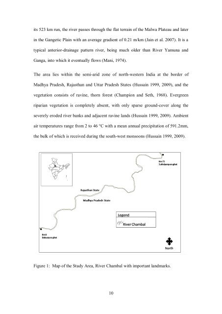
its 523 km run, the river passes through the flat terrain of the Malwa Plateau <strong>and</strong> later<br />
in the Gangetic Plain with an average gradient of 0.21 m/km (Jain et al. 2007). It is a<br />
typical anterior-drainage pattern river, being much older than River Yamuna <strong>and</strong><br />
Ganga, into which it eventually flows (Mani, 1974).<br />
The area lies within the semi-arid zone of north-western India at the border of<br />
Madhya Pradesh, Rajasthan <strong>and</strong> Uttar Pradesh States (Hussain 1999, 2009), <strong>and</strong> the<br />
vegetation consists of ravine, thorn forest (Champion <strong>and</strong> Seth, 1968). Evergreen<br />
riparian vegetation is completely absent, with only sparse ground-cover along the<br />
severely eroded river banks <strong>and</strong> adjacent ravine l<strong>and</strong>s (Hussain 1999, 2009). Ambient<br />
air temperatures range from 2 to 46 °C with a mean annual precipitation of 591.2mm,<br />
the bulk of which is received during the south-west monsoons (Hussain 1999, 2009).<br />
Figure 1: Map of the Study Area, River Chambal with important l<strong>and</strong>marks.<br />
10