Ecological and anthropogenic covariates ... - GANGAPEDIA
Ecological and anthropogenic covariates ... - GANGAPEDIA
Ecological and anthropogenic covariates ... - GANGAPEDIA

Create successful ePaper yourself
Turn your PDF publications into a flip-book with our unique Google optimized e-Paper software.
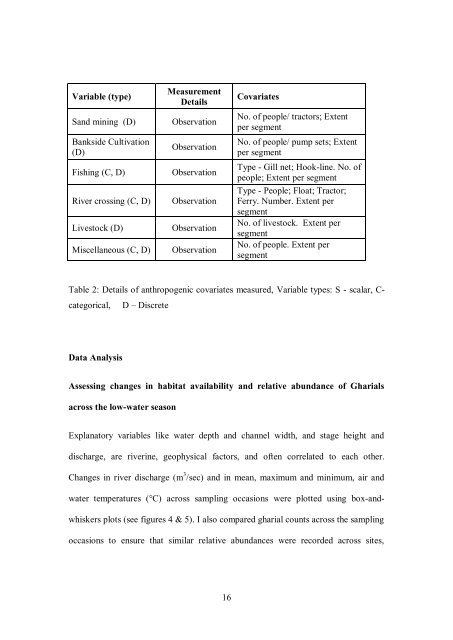
Variable (type)<br />
Measurement<br />
Details<br />
S<strong>and</strong> mining (D) Observation<br />
Bankside Cultivation<br />
(D)<br />
Observation<br />
Fishing (C, D) Observation<br />
River crossing (C, D) Observation<br />
Livestock (D) Observation<br />
Miscellaneous (C, D) Observation<br />
16<br />
Covariates<br />
No. of people/ tractors; Extent<br />
per segment<br />
No. of people/ pump sets; Extent<br />
per segment<br />
Type - Gill net; Hook-line. No. of<br />
people; Extent per segment<br />
Type - People; Float; Tractor;<br />
Ferry. Number. Extent per<br />
segment<br />
No. of livestock. Extent per<br />
segment<br />
No. of people. Extent per<br />
segment<br />
Table 2: Details of <strong>anthropogenic</strong> <strong>covariates</strong> measured, Variable types: S - scalar, C-<br />
categorical, D – Discrete<br />
Data Analysis<br />
Assessing changes in habitat availability <strong>and</strong> relative abundance of Gharials<br />
across the low-water season<br />
Explanatory variables like water depth <strong>and</strong> channel width, <strong>and</strong> stage height <strong>and</strong><br />
discharge, are riverine, geophysical factors, <strong>and</strong> often correlated to each other.<br />
Changes in river discharge (m 3 /sec) <strong>and</strong> in mean, maximum <strong>and</strong> minimum, air <strong>and</strong><br />
water temperatures (°C) across sampling occasions were plotted using box-<strong>and</strong>-<br />
whiskers plots (see figures 4 & 5). I also compared gharial counts across the sampling<br />
occasions to ensure that similar relative abundances were recorded across sites,