Download PDF - Speleogenesis
Download PDF - Speleogenesis
Download PDF - Speleogenesis

Create successful ePaper yourself
Turn your PDF publications into a flip-book with our unique Google optimized e-Paper software.
14<br />
NCKRI Special Paper No. 1<br />
of potentiometric highs and lows are the areas of<br />
downward and upward percolation, or zones of recharge<br />
and discharge. Potentiometric highs correspond to<br />
topographic highs, whereas potentiometric lows coincide<br />
with topographic lows, most commonly river valleys.<br />
Detailed studies of regional hydraulics in many<br />
artesian basins around the world strongly support the<br />
above general views. A brief summary of basinal<br />
hydraulics that follows is derived from thorough regional<br />
studies of the major Ukrainian (Shestopalov, 1981, 1988,<br />
1989) and Canadian (Tóth, 1963; Hitchon, 1969a, 1969b)<br />
basins to illustrate some important implications to<br />
hypogenic speleogenesis.<br />
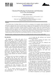
At the basin scale, the overall surface topography,<br />
along with lithologic and structural factors, controls<br />
distribution of potentiometric highs and lows and<br />
determines directions of cross-formational communication<br />
across confining beds. Downward percolation prevails<br />
along major divides, whereas notable upward flow is<br />
characteristic of areas below river valleys and other<br />
topographic lows. Regional confining formations of low<br />
permeability reduce cross-formation communication<br />
within multiple-aquifer systems, but do not isolate aquifers<br />
completely. The effects of topography can be traced to<br />
considerable depths in artesian basins. In particular, the<br />
draining influence of major rivers commonly extends to<br />
depths of 1000-1500 m and more (Shestopalov, 1989;<br />
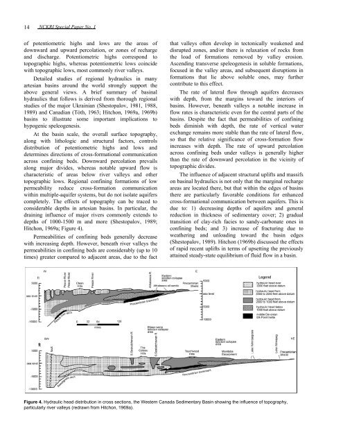
Hitchon, 1969a; Figure 4).<br />
Permeabilities of confining beds generally decrease<br />
with increasing depth. However, beneath river valleys the<br />
permeabilities in confining beds are considerably (up to 10<br />
times) greater compared to adjacent areas, due to the fact<br />
that valleys often develop in tectonically weakened and<br />
disrupted zones, and/or there is relaxation of rocks from<br />
the load of formations removed by valley erosion.<br />
Ascending transverse speleogenesis in soluble formations,<br />
focused in the valley areas, and subsequent disruptions in<br />
formations that lie above soluble ones, may further<br />
contribute to this effect.<br />
The rate of lateral flow through aquifers decreases<br />
with depth, from the margins toward the interiors of<br />
basins. However, beneath valleys a notable increase in<br />
flow rates is characteristic even for the central parts of the<br />
basins. Despite the fact that permeabilities of confining<br />
beds diminish with depth, the rate of vertical water<br />
exchange remains more stable than the rate of lateral flow,<br />
so that the relative significance of cross-formation flow<br />
increases with depth. The rate of upward percolation<br />
across confining beds under valleys is generally higher<br />
than the rate of downward percolation in the vicinity of<br />
topographic divides.<br />
The influence of adjacent structural uplifts and massifs<br />
on basinal hydraulics is not only that the marginal recharge<br />
areas are located there, but that within the edges of basins<br />
there are particularly favorable conditions for enhanced<br />
cross-formational communication between aquifers. This is<br />
due to: 1) decreasing depths of aquifers and general<br />
reduction in thickness of sedimentary cover; 2) gradual<br />
transition of clay-rich facies to sandy-carbonate ones in<br />
confining beds; and 3) increase of fracturing due to<br />
weathering and unloading toward the basin edges<br />
(Shestopalov, 1989). Hitchon (1969b) discussed the effects<br />
of rapid recent uplifts in terms of upsetting the previously<br />
attained steady-state equilibrium of fluid flow in a basin.<br />
Figure 4. Hydraulic head distribution in cross sections, the Western Canada Sedimentary Basin showing the influence of topography,<br />
particularly river valleys (redrawn from Hitchon, 1969a).