Quantifying Uncontrolled Landfill Gas Emissions from Two Florida ...
Quantifying Uncontrolled Landfill Gas Emissions from Two Florida ...
Quantifying Uncontrolled Landfill Gas Emissions from Two Florida ...

Create successful ePaper yourself
Turn your PDF publications into a flip-book with our unique Google optimized e-Paper software.
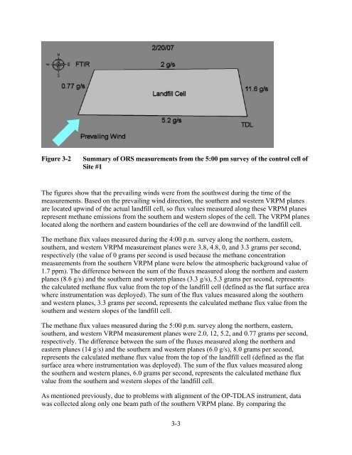
Figure 3-2 Summary of ORS measurements <strong>from</strong> the 5:00 pm survey of the control cell of<br />
Site #1<br />
The figures show that the prevailing winds were <strong>from</strong> the southwest during the time of the<br />
measurements. Based on the prevailing wind direction, the southern and western VRPM planes<br />
are located upwind of the actual landfill cell, so flux values measured along these VRPM planes<br />
represent methane emissions <strong>from</strong> the southern and western slopes of the cell. The VRPM planes<br />
located along the northern and eastern boundaries of the cell are downwind of the landfill cell.<br />
The methane flux values measured during the 4:00 p.m. survey along the northern, eastern,<br />
southern, and western VRPM measurement planes were 3.8, 4.8, 0, and 3.3 grams per second,<br />
respectively (the value of 0 grams per second is used because the methane concentration<br />
measurements <strong>from</strong> the southern VRPM plane were below the atmospheric background value of<br />
1.7 ppm). The difference between the sum of the fluxes measured along the northern and eastern<br />
planes (8.6 g/s) and the southern and western planes (3.3 g/s), 5.3 grams per second, represents<br />
the calculated methane flux value <strong>from</strong> the top of the landfill cell (defined as the flat surface area<br />
where instrumentation was deployed). The sum of the flux values measured along the southern<br />
and western planes, 3.3 grams per second, represents the calculated methane flux value <strong>from</strong> the<br />
southern and western slopes of the landfill cell.<br />
The methane flux values measured during the 5:00 p.m. survey along the northern, eastern,<br />
southern, and western VRPM measurement planes were 2.0, 12, 5.2, and 0.77 grams per second,<br />
respectively. The difference between the sum of the fluxes measured along the northern and<br />
eastern planes (14 g/s) and the southern and western planes (6.0 g/s), 8.0 grams per second,<br />
represents the calculated methane flux value <strong>from</strong> the top of the landfill cell (defined as the flat<br />
surface area where instrumentation was deployed). The sum of the flux values measured along<br />
the southern and western planes, 6.0 grams per second, represents the calculated methane flux<br />
value <strong>from</strong> the southern and western slopes of the landfill cell.<br />
As mentioned previously, due to problems with alignment of the OP-TDLAS instrument, data<br />
was collected along only one beam path of the southern VRPM plane. By comparing the<br />
3-3