Meru South District - UNDP-UNEP Poverty-Environment Initiative
Meru South District - UNDP-UNEP Poverty-Environment Initiative
Meru South District - UNDP-UNEP Poverty-Environment Initiative

Create successful ePaper yourself
Turn your PDF publications into a flip-book with our unique Google optimized e-Paper software.
CHAPTER 2: DISTRICT PROFILE<br />
2.1 Geographical Location, Size and Administrative Units<br />
<strong>Meru</strong> <strong>South</strong> is one among Thirteen <strong>District</strong>s in Eastern Province. It was curved out of the<br />
larger <strong>Meru</strong> district in 1992 to create the former Tharaka Nithi <strong>District</strong>. In 1997 Tharaka<br />
Nithi <strong>District</strong> was divided into two creating the Tharaka <strong>District</strong> and <strong>Meru</strong> <strong>South</strong> <strong>District</strong>s<br />
respectively. It is situated between Longitudes 37 18’37”and 37 28’33”East & Latitude<br />
00 07’23” and 00 26’19”<strong>South</strong>.<br />
The total area of the <strong>District</strong> is 1092.9km 2 and this includes 360km 2 of Mt. Kenya forest.<br />
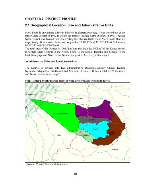
It borders <strong>Meru</strong> Central to the North, Embu to the <strong>South</strong>, Tharaka and Mbeere to the<br />
East, Kirinyaga and Nyeri to the West at the peak of Mt. Kenya. See map 1<br />
Administrative Units and Local Authorities<br />
The <strong>District</strong> is divided into five administrative Divisions namely Chuka, Igamba<br />
Ng’ombe, Magumoni, Muthambi and Mwimbi Divisions. It has a total of 25 locations<br />
and 76 sub locations see map 2.<br />
Map 1: <strong>Meru</strong> <strong>South</strong> district map showing divisional/district boundaries.<br />
(Source: Central Bureau of Statistics)<br />
10