vynnunt ųiatfr - State Law Publisher
vynnunt ųiatfr - State Law Publisher
vynnunt ųiatfr - State Law Publisher
Create successful ePaper yourself
Turn your PDF publications into a flip-book with our unique Google optimized e-Paper software.
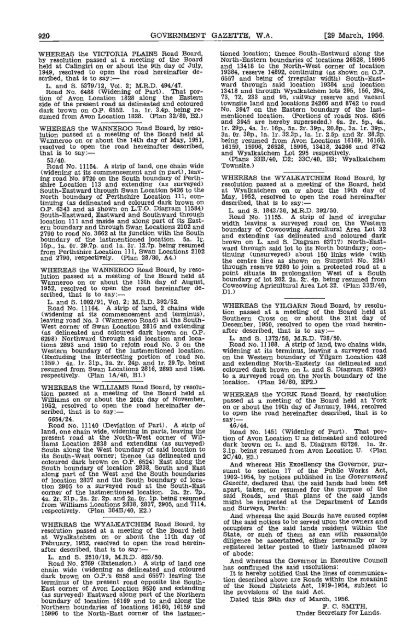
920 GOVERNMENT GAZETTE, W.A. [29 March, 1956.<br />
WHEREAS the VICTORIA PLAINS Road Board,<br />
by resolution passed at a meeting of the Board<br />
held at Calingiri on or about the 9th day of July,<br />
1949, resolved to open the road hereinafter described,<br />
that is to say:<br />
L. and S. 5379/12, Vol. 2; M.R.D. 494/47.<br />
Road No. 6483 (Widening of Part). That portion<br />
of Avon Location 1828 along the Eastern<br />
side of the present road as delineated and coloured<br />
dark brown on OP. 6552. la. lr. 3.4p. being resumed<br />
from Avon Looation 1828. (Plan 32/80, B2.)<br />
WHEREAS the WANNEROO Road Board, by resolution<br />
passed at a meeting of the Board held at<br />
Wanneroo on or about the 14th day of May, 1951,<br />
resolved to open the road hereinafter described,<br />
that is to say:-<br />
53/40.<br />
Road No. 11154. A strip of land, one chain wide<br />
(widening at its commencement and in part), leaving<br />
road No. 9720 on the South boundary of Perthshire<br />
Location 113 and extending (as surveyed)<br />
South-Eastward through Swan Location 5426 to the<br />
North boundary of Perthshire Location 111, continuing<br />
(as delineated and coloured dark brown on<br />
OP. 6343 and as shown on L.T.O. Diagram 11584)<br />
South-Eastward, Eastward and Southward through<br />
location 111 and inside and along part of its Eastern<br />
boundary and through Swan Locations 2102 and<br />
2790 to road No. 3662 at its junction with the South<br />
boundary of the lastmentioned location. 5a. 1i.<br />
isp., la. Or. 29.7p and la. 3r. 12.7p. being resumed<br />
from Perthshire Location 111, Swan Locations 2102<br />
and 2790, respectively. (Plan 28/SO, A4.)<br />
WHEREAS the WANNEROO Road Board, by resolution<br />
passed at a meeting of the Board held at<br />
Wanneroo on or about the 13th day of August,<br />
1952, resolved to open the road hereinafter de-<br />
scribed, that is to say:<br />
L. and S 1002/91, Vol. 2; M.R.D. 392/52.<br />
Road No. 11164. A strip of land, 2 chains wide<br />
(widening at its commencement and terminus),<br />
leaving road No. 3 (Wanneroo Road) at the South-<br />
West corner of Swan Location 2816 and extending<br />
(as delineated and coloured dark brown on OP.<br />
6298) Northward through said location and locations<br />
2893 and 1590 to rejoin road No. 3 on the<br />
Western boundary of the lastmentioned location.<br />
(Excluding the intersecting portion of road No.<br />
1359.) 4a. lr. 31p.. 3a. 2r. 24p. and lr. 29.7p. being<br />
resumed from Swan Locations 2816, 2893 and 1590,<br />
respectively. (Plan 1A/4O, B1.)<br />
WHEREAS the WILLIAMS Road Board, by resolution<br />
passed at a meeting of the Board held at<br />
Williams on or about the 20th day of November,<br />
1952, resolved to open the road hereinafter described,<br />
that is to say:-<br />
6654/24.<br />
Road No. 11140 (Deviation of Part). A strip of<br />
land, one chain wide, widening in parts, leaving the<br />
present road at the North-West corner of Williams<br />
Location 2838 and extending (as surveyed)<br />
South along the West boundary of said location to<br />
its South-West corner; thence (as delineated and<br />
coloured dark brown on O,P. 6524) East along the<br />
South boundary of location 2838, South and East<br />
along part of the West and the South boundaries<br />
of location 2837 and the South boundary of location<br />
2905 to a surveyed road at the South-East<br />
corner of the lastmentioned location. 3a. 2r. 7p.,<br />
4a. 2r. 21p., 2a. 2r. 2p. and 2a Or ip. being resumed<br />
from Williams Locations 2838, 2837, 2905, and '7114,<br />
respectively. (Plan 384B/4O, E2.)<br />
WHEREAS the WYALKATCHEM Road Board, by<br />
resolution passed at a meeting of the Board held<br />
at Wyalkatchem on or about the 11th day of<br />
February, 1952, resolved to open the road hereinafter<br />
described, that is to say:<br />
L. and 5. 2510/19, M.R.D. 823/50.<br />
Road No. 2769 (Extension.) A strip of land one<br />
chain wide (widening as delineated and coloured<br />
dark brown on O.P.'s 6558 and 6557) leaving the<br />
terminus of the present road opposite the South-<br />
East corner of Avon Location 9530 and extending<br />
(as surveyed) Eastward along part of the Northern<br />
boundary of location 16169 and to and along the<br />
Northern boundaries of locations 16160, 16159 and<br />
15996 to the North-East corner of the lastmen-<br />
tioned location; thence South-Eastward along the<br />
North-Eastern boundaries of locations 26528, 15995<br />
and 13418 to the North-West corner of location<br />
19384, reserve 14892, continuing (as shown on OP.<br />
6557 and being of irregular width) South-Eastward<br />
through said location 19384 and location<br />
13418 and through Wyalkatchem lots 295, 156, 294,<br />
73, 72, 233 and 95, railway reserve and vacant<br />
townsite land and locations 24266 and 8742 to road<br />
No. 3947 on the Eastern boundary of the lastmentioned<br />
location. (Portions of roads Nos. 6305<br />
and 3945 are hereby superseded.) Ga. 2r. 5p., 4a.<br />
lr. 29p., 4a. lr. 16p., Sa. 2r. 39p., 2O.8p., 3a. ir. 39p.,<br />
3a, Or. 38p., la. lr. 32.3p., la. ir. 2.Sp. and 2r. 28.2p.<br />
being resumed from Avon Locations 16169, 16160,<br />
16159, 15996, 26528, 15995, 13418, 24266 and 8742<br />
and Wyalkatchem Lot 295 respectively.<br />
(Plans 33B/40, D2; 33C/40, E3; Wyalkatchem<br />
Townsite.)<br />
WHEREAS the WYALKATCHEM Road Board, by<br />
resolution passed at a meeting of the Board, held<br />
at Wyalkatchem on or about the 19th day of<br />
May, 1952, resolved to open the road hereinafter<br />
described, that is to say:<br />
L. and 5. 1843/30, M.R.D. 392/50.<br />
Road No. 11155. A strip of land of irregular<br />
width leaving a surveyed road on the Western<br />
boundary of Covcowing Agricultural Area Lot 32<br />
and extending (as delineated and coloured dark<br />
brown on L. and S. Diagram 63717) North-Eastward<br />
through said lot to its North boundary; continuing<br />
(unsurveyed) about 150 links wide (with<br />
the centre line as shown on Sunprint No. 224)<br />
through reserve 9280 to join a protected road at a<br />
point situate in prolongation West of a South<br />
boundary of lot 202. 2a. 2r. 4p. being resumed from<br />
Cowcowing Agricultural Area Lot 32. (Plan 33B/40,<br />
Dl.)<br />
WHEREAS the YILGARN Road Board, by resolution<br />
passed at a meeting of the Board held at<br />
Southern Cross on or about the 21st day of<br />
December, 1950, resolved to open the road hereinafter<br />
described, that is to say:<br />
L. and 5. 1372/50, M.R.D. 738/50.<br />
Road No. 11188. A strip of land, two chains wide,<br />
widening at its terminus, leaving a surveyed road<br />
on the Western boundary of Yilgarn Location 428<br />
and extending North-Easterly (as delineated and<br />
coloured dark brown on L and S. Diagram 62992)<br />
to a surveyed road on the North boundary of the<br />
location. (Plan 36/80, EF2.)<br />
WHEREAS the YORK Road Board, by resolution<br />
passed at a meeting of the Board held at York<br />
on or about the 19th day of January, 1944, resolved<br />
to open the road hereinafter described, that is to<br />
say<br />
46/44.<br />
Road No. 1451 (Widening of Part). That portion<br />
of Avon Location U as delineated and coloured<br />
dark brown on L. and S. Diagram 63726. la. 2r.<br />
3.lp. being resumed from Avon Location U. (Plan<br />
2C/4O, E3.)<br />
And whereas His Excellency the Governor, pursuant<br />
to section 17 of the Public Works Act,<br />
1902-1954, by notices published in the Government<br />
Gazette, declared that the said lands had been set<br />
apart, taken, or resumed for the purpose of the<br />
said Roads and that plans of the said lands<br />
might be inspected at the Department of Lands<br />
and Surveys, Perth:<br />
And whereas the said Boards have caused copies<br />
of the said notices to be served upon the owners and<br />
occupiers of the said lands resident within the<br />
<strong>State</strong>, or such of them as can with reasonable<br />
diligence be ascertained, either personally or )y<br />
registered letter posted to their lastnamed places<br />
of abode:<br />
And whereas the Governor in Executive Council<br />
has confirmed the said resolutions:<br />
It is hereby notified that the lines of communication<br />
described above are Roads within the meaning<br />
of the Road Districts Act, 1919-1954, subject to<br />
the provisions of the said Act.<br />
Dated this 29th day of March, 1956.<br />
F. C. SMITH,<br />
Under Secretary for Lands.


