

Review of Greenland Avtivities 2001 - Geus
Review of Greenland Avtivities 2001 - Geus
Review of Greenland Avtivities 2001 - Geus

You also want an ePaper? Increase the reach of your titles
YUMPU automatically turns print PDFs into web optimized ePapers that Google loves.
▲ ▲ ▲<br />
▲<br />
▲ ▲ ▲<br />
▲<br />
▲<br />
▲<br />
▲<br />
▲<br />
Boye Sø<br />
Nuussuaq<br />
Puiattup Qaqqaa shear zone<br />
Puiattup Qaqqaa<br />
▲<br />
Itilli<br />
▲ ▲<br />
Saqqaq<br />
Ikorfat<br />
Oqaatsut<br />
Itilliarsuup Nuua<br />
▲ ▲ ▲<br />
▲ ▲<br />
▲<br />
▲ ▲ ▲<br />
Torsukattak<br />
Inussuk<br />
Anap<br />
Nunaa<br />
70°<br />
<strong>Greenland</strong><br />
R<br />
Ataa<br />
domain<br />
▲<br />
▲<br />
▲ ▲<br />
▲<br />
N<br />
▲ ▲<br />
▲<br />
Laksebugt<br />
Ataa<br />
▲<br />
▲<br />
▲<br />
▲ ▲<br />
▲<br />
▲<br />
69°<br />
▲<br />
Quaternary deposits<br />
Cretaceous–Palaeogene province<br />
Arveprinsen<br />
Ejland<br />
▲ ▲ ▲ ▲<br />
▲<br />
▲ ▲<br />
▲<br />
▲<br />
▲<br />
Palaeoproterozoic<br />
▲<br />
▲ ▲ ▲<br />
▲ ▲<br />
Shear zone<br />
▲<br />
▲<br />
▲<br />
▲<br />
▲<br />
Archaean<br />
Ductile thrust<br />
Albitised rocks<br />
Dolerite dykes and sills<br />
Anap nunâ Group: sandstone, siltstone<br />
Anap nunâ Group: marble<br />
Discordant granitic bodies (c. 2750 Ma)<br />
Qitermiunnguit<br />
'Falcon<br />
cliff'<br />
Paakitsoq<br />
▲<br />
▲ ▲<br />
▲<br />
▲<br />
▲<br />
▲<br />
▲<br />
▲<br />
▲<br />
▲<br />
▲<br />
▲<br />
▲<br />
▲<br />
▲<br />
▲<br />
▲<br />
▲<br />
69°<br />
Atâ tonalite (c. 2800 Ma)<br />
Rodebay granodiorite<br />
Inland Ice<br />
Tonalitic–granodioritic orthogneiss<br />
Dioritic gneiss<br />
Augen granite (Saqqaq, Nuussuaq)<br />
Rodebay<br />
Itilli diorite (Nuussuaq)<br />
Acid metavolcanic rocks<br />
Pillow lava and undifferentiated amphibolite<br />
Nunatarsuaq<br />
Metagabbro<br />
Garnet-mica schist<br />
Muscovite schist<br />
Anorthosite<br />
10 km<br />
Ilulissat<br />
52°<br />
50°<br />
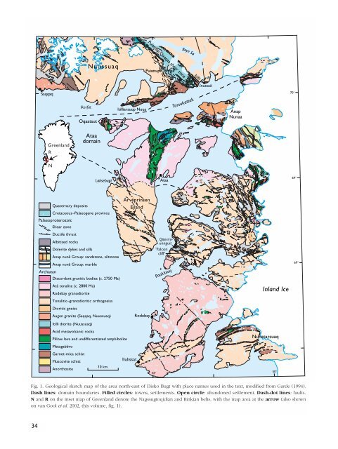
Fig. 1. Geological sketch map <strong>of</strong> the area north-east <strong>of</strong> Disko Bugt with place names used in the text, modified from Garde (1994).<br />
Dash lines: domain boundaries. Filled circles: towns, settlements. Open circle: abandoned settlement. Dash-dot lines: faults.<br />
N and R on the inset map <strong>of</strong> <strong>Greenland</strong> denote the Nagssugtoqidian and Rinkian belts, with the map area at the arrow (also shown<br />
on van Gool et al. 2002, this volume, fig. 1).<br />
34


