

Review of Greenland Avtivities 2001 - Geus
Review of Greenland Avtivities 2001 - Geus
Review of Greenland Avtivities 2001 - Geus

Create successful ePaper yourself
Turn your PDF publications into a flip-book with our unique Google optimized e-Paper software.
56° 54°<br />
52°<br />
72°<br />
72°<br />
nT<br />
71°30′<br />
71°<br />
70°30′<br />
50 km<br />
71°30′<br />
71°<br />
0.335<br />
0.223<br />
0.163<br />
0.122<br />
0.092<br />
0.068<br />
0.051<br />
0.037<br />
0.027<br />
0.019<br />
0.014<br />
0.010<br />
0.006<br />
0.004<br />
0.001<br />
– 0.001<br />
– 0.003<br />
– 0.005<br />
– 0.007<br />
– 0.009<br />
– 0.011<br />
– 0.014<br />
– 0.016<br />
– 0.021<br />
– 0.027<br />
– 0.035<br />
– 0.049<br />
– 0.077<br />
– 0.126<br />
– 0.210<br />
– 0.402<br />
56° 54° 52°<br />
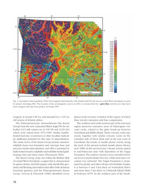
Fig. 3. Calculated vertical gradient <strong>of</strong> the total magnetic field intensity with shaded relief for the area in central West <strong>Greenland</strong> covered<br />
by project Aeromag <strong>2001</strong>. The location <strong>of</strong> the aeromagnetic survey in <strong>2001</strong> is circumscribed by a grey line and the new data have<br />
been merged with data from project Aeromag 1997.<br />
orogeny at around 1.85 Ga, and intruded by a 1.65 Ga<br />
old swarm <strong>of</strong> dolerite dykes.<br />
The Palaeoproterozoic metasediments (the Karrat<br />
Group) host the now exhausted Black Angel Pb-Zn ore<br />
bodies (13.5 mill. tonnes ore at 4.0% Pb and 12.3% Zn)<br />
which were mined from 1973–1990. Similar marblehosted<br />
lead-zinc occurrences at other localities indicate<br />
an additional potential for this type <strong>of</strong> mineralisation.<br />
The clastic facies <strong>of</strong> the Karrat Group include extensive<br />
sulphide facies iron formation and vein-type base and<br />
precious metals mineralisation, and <strong>of</strong>fer a potential for<br />
shale-hosted massive sulphides and turbidite-hosted goldbearing<br />
veins and shear zones (Thomassen 1992).<br />
The Karrat Group crops out within the Rinkian Belt<br />
<strong>of</strong> central West <strong>Greenland</strong>, a region that is characterised<br />
by gneiss domes and fold nappes with sheath-like geometry<br />
and flat-lying axial surfaces that affect both Archaean<br />
basement gneisses and the Palaeoproterozoic Karrat<br />
Group. Grocott & Pulvertaft (1990) identified seven<br />
phases in the tectonic evolution <strong>of</strong> the region, <strong>of</strong> which<br />
three involve extension and four compression.<br />
The southern and south-western part <strong>of</strong> the surveyed<br />
region preserves extensive areas <strong>of</strong> Palaeogene volcanic<br />
rocks, related to the plate break-up between<br />
<strong>Greenland</strong> and Baffin Island. These volcanic rocks represent,<br />
together with similar volcanic rocks on the<br />
Canadian side <strong>of</strong> Davis Strait and on the east coast <strong>of</strong><br />
<strong>Greenland</strong>, the results <strong>of</strong> mantle plume activity along<br />
the track <strong>of</strong> the present Iceland mantle plume (Storey<br />
et al. 1998). In the surveyed area volcanic activity started<br />
in mid-Paleocene time with deposition <strong>of</strong> the Vaigat<br />
Formation. The earliest volcanics were extruded below<br />
sea level as hyaloclastite breccias, while most later volcanism<br />
was subaerial. The Vaigat Formation is dominated<br />
by picritic and other olivine-rich tholeiitic basalts;<br />
it is between 0 and 3 km thick on Svartenhuk Halvø<br />
and more than 5 km thick on Ubekendt Ejland (Hald<br />
& Pedersen 1975). In the northern part <strong>of</strong> the basalt-<br />
70


