

Seychelles Damage, Loss, and Needs Assessment (DaLA ... - GFDRR
Seychelles Damage, Loss, and Needs Assessment (DaLA ... - GFDRR
Seychelles Damage, Loss, and Needs Assessment (DaLA ... - GFDRR

You also want an ePaper? Increase the reach of your titles
YUMPU automatically turns print PDFs into web optimized ePapers that Google loves.
46<br />
<strong>Seychelles</strong> <strong>Damage</strong>, <strong>Loss</strong> <strong>and</strong> <strong>Needs</strong> <strong>Assessment</strong> (<strong>DaLA</strong>) 2013 Floods<br />
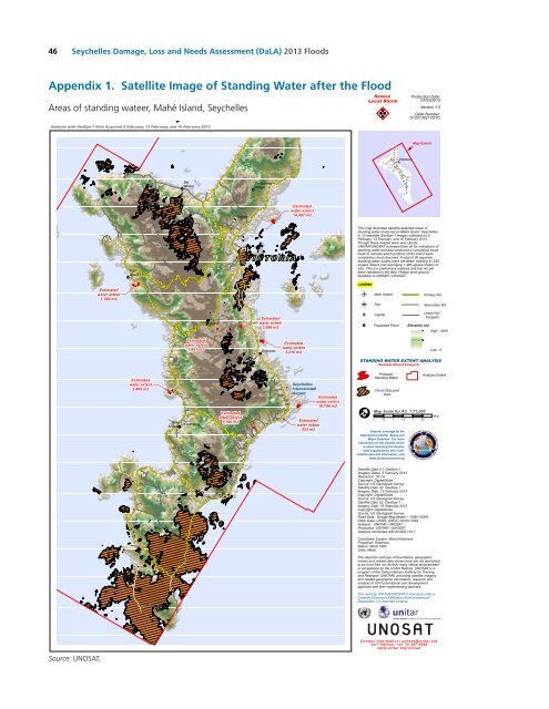
Appendix 1. Satellite Image of St<strong>and</strong>ing Water after the Flood<br />
Areas of st<strong>and</strong>ing wateer, Mahé Isl<strong>and</strong>, <strong>Seychelles</strong><br />
Analysis with GeoEye-1 Data Acquired 5 February, 13 February, <strong>and</strong> 16 February 2013<br />
Severe<br />
Local Storm<br />
!Y<br />
Production Date:<br />
07/03/2013<br />
Version 1.0<br />
Glide Number:<br />
ST20130212SYC<br />
FMap Extent<br />
S E Y C H E L L E S<br />
Port<br />
Glaud<br />
¥¦¬ Victoria<br />
Bel<br />
Ombre<br />
De Quincey<br />
Village<br />
Au<br />
Cap<br />
!L<br />
Victoria<br />
Estimated<br />
water extent<br />
14,497 m2<br />
Port<br />
Glaud<br />
¥¦¬<br />
This map illustrates satellite-detected areas of<br />
st<strong>and</strong>ing water observed on Mahé Isl<strong>and</strong>, <strong>Seychelles</strong>,<br />
in 12 separate GeoEye-1 images collected on 5<br />
February, 13 February, <strong>and</strong> 16 February 2013.<br />
Though these images were very cloudy<br />
UNITAR/UNOSAT reviewed them all for indications of<br />
st<strong>and</strong>ing water <strong>and</strong> also produced a cumulative cloud<br />
mask to indicate which portions of the isl<strong>and</strong> were<br />
completely cloud obscured. A total of 28 separate<br />
st<strong>and</strong>ing water bodies were identified, totalling 41,025<br />
square meters <strong>and</strong> averaging 1,465 square meters in<br />
size. This is a preliminary analysis <strong>and</strong> has not yet<br />
been validated in the field. Please send ground<br />
feedback to UNITAR / UNOSAT.<br />
LEGEND<br />
Estimated<br />
water extent<br />
1,389 m2<br />
!I<br />
Main Airport<br />
Primary Rd.<br />
Misere<br />
Mahe<br />
Estimated<br />
water extent<br />
2,686 m2<br />
!L Port<br />
¥¦¬ Capital<br />
Populated Place<br />
Secondary Rd.<br />
Urban Rd./<br />
Footpath<br />
Elevation (m)<br />
High : 4000<br />
Estimated<br />
water extent<br />
1,651 m2<br />
Cascade<br />
Estimated<br />
water extent<br />
5,210 m2<br />
Low : 0<br />
STANDING WATER EXTENT ANALYSIS<br />
(Satellite-Based Analysis)<br />
Estimated<br />
water extent<br />
2,486 m2<br />
Anse<br />
Boileau<br />
L'Esperance<br />
Estimated<br />
water extent<br />
1,785 m2<br />
!I<br />
<strong>Seychelles</strong><br />
International<br />
Airport<br />
Estimated<br />
water extent<br />
10,790 m2<br />
Estimated<br />
water extent<br />
523 m2<br />
!I<br />
Probable<br />
St<strong>and</strong>ing Water<br />
Cloud Obscured<br />
Area<br />
Map Scale for A3: 1:71,000<br />
0 0.5 1 1.5 2 2.5 3<br />
Disaster coverage by the<br />
International Charter 'Space <strong>and</strong><br />
Major Disasters'. For more<br />
information on the Charter, which<br />
is about assisting the disaster<br />
relief organizations with multisatellite<br />
data <strong>and</strong> information, visit<br />
www.disasterscharter.org<br />
Analysis Extent<br />
Km<br />
Takamaka<br />
Anse<br />
Royale<br />
Satellite Data (1): GeoEye-1<br />
Imagery Dates: 5 February 2013<br />
Resolution: 50 cm<br />
Copyright: DigitalGlobe<br />
Source: US Geological Survey<br />
Satellite Data (2): GeoEye-1<br />
Imagery Date: 13 February 2013<br />
Copyright: DigitalGlobe<br />
Source: US Geological Survey<br />
Satellite Data (3): GeoEye-1<br />
Imagery Date: 16 February 2013<br />
Copyright: DigitalGlobe<br />
Source: US Geological Survey<br />
Road Data : Google Map Maker / OSM / ESRI<br />
Other Data: USGS, UNCS, NASA, NGA<br />
Analysis : UNITAR / UNOSAT<br />
Production: UNITAR / UNOSAT<br />
Analysis conducted with ArcGIS v10.1<br />
Coordinate System: World Robinson<br />
Projection: Robinson<br />
Datum: WGS 1984<br />
Units: Meter<br />
The depiction <strong>and</strong> use of boundaries, geographic<br />
names <strong>and</strong> related data shown here are not warranted<br />
to be error-free nor do they imply official endorsement<br />
or acceptance by the United Nations. UNOSAT is a<br />
program of the United Nations Institute for Training<br />
<strong>and</strong> Research (UNITAR), providing satellite imagery<br />
<strong>and</strong> related geographic information, research <strong>and</strong><br />
analysis to UN humanitarian <strong>and</strong> development<br />
agencies <strong>and</strong> their implementing partners.<br />
This work by UNITAR/UNOSAT is licensed under a<br />
Creative Commons Attribution-NonCommercial-<br />
ShareAlike 3.0 Unported License.<br />
Source: UNOSAT.<br />
Contact Information: unosat@unitar.org<br />
24/7 Hotline: +4 1 76 487 4998<br />
www.unitar.org/unosat


