Marr
marr.pdf
marr.pdf

Create successful ePaper yourself
Turn your PDF publications into a flip-book with our unique Google optimized e-Paper software.
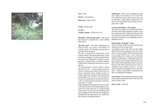
Area : <strong>Marr</strong><br />
Parish : Kennethmont<br />
Kirkyard : Christ’s Kirk.<br />
N.G.R. : NJ 605 268<br />
S.A.M. :<br />
Listing Category : Kirkyard Cat. C.<br />
Boundary wall and gate piers : The site of<br />
the kirkyard is surounded by a wall of rubble<br />
field stones.<br />
The Old Kirk : The kirk of Rathmuriel or<br />
Christ’s Kirk, was given to the Abbey of<br />
Lindores before 1195 though not much else is<br />
recorded about the place.<br />
The area is reputed to be named after a holy<br />
woman, Muriel, who had an abode there. A connection<br />
was thought to exist between the Thanes<br />
of Cawdor and Rathmuriel, as Muriel was apparently<br />
a common name to female members<br />
of that family, though this connection was never<br />
proved.<br />
The nomenclature of Christ’s Kirk is said to<br />
date from the 15 th - century and has been likened<br />
to a similar term used at Udny Green, as<br />
being a beautiful place perhaps worthy of<br />
Christ. Indeed the situation of the old kirk has<br />
commanding views to the E. over the Garioch.<br />
Jervise also stated that the old kirk ran from E.<br />
to W., as was the typical orientation, and measured<br />
26 by 12 yards.<br />
Today nothing can be determined of the remains<br />
of the kirk due to the site being completely overgrown<br />
by weeds and trees. It is believed that<br />
stones from it were used in the building of the<br />
farm steadings beside the kirkyard, though it is<br />
doubtful that the gravestones too would have<br />
been lifted for building material ?<br />
Tombstones : There are no tombstones of any<br />
type visible, not even those of 1716 and 1767<br />
as recorded by Jervise. These stones were said<br />
to each bear a nude figure representative of<br />
Time with outstretched arms bearing an hourglass<br />
and a scythe<br />
Conservation Digest : Not Urgent.<br />
The entire site needs to be cleared of all undergrowth<br />
to thoroughly determine whether or not<br />
any tombstones exist within the kirkyard. The<br />
exact position of the kirk should also be ascertained<br />
by an analysis of the topography or geographical<br />
survey.<br />
Interpretative Potential : None.<br />
There is nothing visible to indicate that this was<br />
indeed the site of an early kirk.<br />
According to Jervise the kirk was also called<br />
Sleepy Kirk because adjacent to the site of the<br />
kirk was once a small village that played host<br />
to an annual Christ’s Fair, more commonly<br />
called the Sleepy Fair. This fair, to buy and sell<br />
timber and all manner of merchant goods, began<br />
at sunset and continued until the first hour<br />
after sunrise at the beginning of June as it never<br />
became truly dark at that time of year. This information<br />
was recorded in 1724, c. 35 years<br />
after the proprietor changed the fair to the daytime,<br />
- owing to great public consternation the<br />
fair was abandoned altogether.<br />
Access issues :The kirkyard is located up a farm<br />
track between Insch and Leslie in the area still<br />
called Christ’s Kirk.<br />
Date of visit : 28/07/98.<br />
158