

Boundary-layer height detection with a ceilometer at a coastal ... - Orbit
Boundary-layer height detection with a ceilometer at a coastal ... - Orbit
Boundary-layer height detection with a ceilometer at a coastal ... - Orbit

Create successful ePaper yourself
Turn your PDF publications into a flip-book with our unique Google optimized e-Paper software.
2.7 <strong>Boundary</strong>-<strong>layer</strong> clouds<br />
The presence of clouds gre<strong>at</strong>ly influences boundary-<strong>layer</strong> dynamics and the surface we<strong>at</strong>her.<br />
Many cloud types are an essential fe<strong>at</strong>ure of the ABL and cannot be separ<strong>at</strong>ed from boundary<strong>layer</strong><br />
studies. These clouds are mainly the low clouds, limited in their vertical extent. They<br />
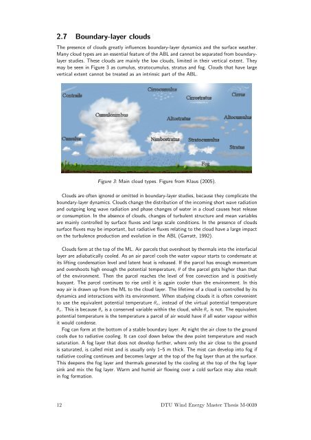
may be seen in Figure 3 as cumulus, str<strong>at</strong>ocumulus, str<strong>at</strong>us and fog. Clouds th<strong>at</strong> have large<br />
vertical extent cannot be tre<strong>at</strong>ed as an intrinsic part of the ABL.<br />
Figure 3: Main cloud types. Figure from Klaus (2005).<br />
Clouds are often ignored or omitted in boundary-<strong>layer</strong> studies, because they complic<strong>at</strong>e the<br />
boundary-<strong>layer</strong> dynamics. Clouds change the distribution of the incoming short wave radi<strong>at</strong>ion<br />
and outgoing long wave radi<strong>at</strong>ion and phase changes of w<strong>at</strong>er in a cloud causes he<strong>at</strong> release<br />
or consumption. In the absence of clouds, changes of turbulent structure and mean variables<br />
are mainly controlled by surface fluxes and large scale conditions. In the presence of clouds<br />
surface fluxes may be important, but radi<strong>at</strong>ive fluxes rel<strong>at</strong>ing to the cloud have a large impact<br />
on the turbulence production and evolution in the ABL (Garr<strong>at</strong>t, 1992).<br />
Clouds form <strong>at</strong> the top of the ML. Air parcels th<strong>at</strong> overshoot by thermals into the interfacial<br />
<strong>layer</strong> are adiab<strong>at</strong>ically cooled. As an air parcel cools the w<strong>at</strong>er vapour starts to condens<strong>at</strong>e <strong>at</strong><br />
its lifting condens<strong>at</strong>ion level and l<strong>at</strong>ent he<strong>at</strong> is released. If the parcel has enough momentum<br />
and overshoots high enough the potential temper<strong>at</strong>ure, θ of the parcel gets higher than th<strong>at</strong><br />
of the environment. Then the parcel reaches the level of free convection and is positively<br />
buoyant. The parcel continues to rise until it is again cooler than the environment. In this<br />
way air is drawn up from the ML to the cloud <strong>layer</strong>. The lifetime of a cloud is controlled by its<br />
dynamics and interactions <strong>with</strong> its environment. When studying clouds it is often convenient<br />
to use the equivalent potential temper<strong>at</strong>ure θ e , instead of the virtual potential temper<strong>at</strong>ure<br />
θ v . This is because θ e is a conserved variable <strong>with</strong>in the cloud, while θ v is not. The equivalent<br />
potential temper<strong>at</strong>ure is the temper<strong>at</strong>ure a parcel of air would have if all w<strong>at</strong>er vapour <strong>with</strong>in<br />
it would condense.<br />
Fog can form <strong>at</strong> the bottom of a stable boundary <strong>layer</strong>. At night the air close to the ground<br />
cools due to radi<strong>at</strong>ive cooling. It can cool down below the dew point temper<strong>at</strong>ure and reach<br />
s<strong>at</strong>ur<strong>at</strong>ion. A fog <strong>layer</strong> th<strong>at</strong> does not develop further, where only the air close to the ground<br />
is s<strong>at</strong>ur<strong>at</strong>ed, is called mist and is usually only 1–5 m thick. The mist can develop into fog if<br />
radi<strong>at</strong>ive cooling continues and becomes larger <strong>at</strong> the top of the fog <strong>layer</strong> than <strong>at</strong> the surface.<br />
This deepens the fog <strong>layer</strong> and thermals gener<strong>at</strong>ed by the cooling <strong>at</strong> the top of the fog <strong>layer</strong><br />
sink and mix the fog <strong>layer</strong>. Warm and humid air flowing over a cold surface may also result<br />
in fog form<strong>at</strong>ion.<br />
12 DTU Wind Energy Master Thesis M-0039


