Topographic Maps and Digital Elevation Models
Topographic Maps and Digital Elevation Models
Topographic Maps and Digital Elevation Models
You also want an ePaper? Increase the reach of your titles
YUMPU automatically turns print PDFs into web optimized ePapers that Google loves.
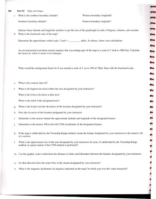
108 Part III <strong>Maps</strong> <strong>and</strong> Images<br />
c. What is the northern boundary latitude?<br />
Southern boundary latitude?<br />
Western boundary longitude?<br />
Eastern boundary longitude?<br />
Subtract these latitude <strong>and</strong> longitude numbers to get the size of the quadrangle in units of degrees, minutes, <strong>and</strong> seconds.<br />
d. What is the fractional scale of the map?<br />
Determine the approximate verbal scale: I inch =<br />
miles. As always, show your calculations.<br />
An environmental restoration project requires that you enlarge part of the map to a scale of 1 inch to 1000 feet. Calculate<br />
the factor by which it needs to be enlarged.<br />
What would the enlargement factor be if you needed a scale of 1 em to 100 m? Hint: Start with the fractional scale.<br />
e. What is the contour interval?<br />
f. What is the highest elevation within the area designated by your instructor?<br />
What is the lowest elevation in that area?<br />
What is the relief of the designated area?<br />
g. What is the height (not the elevation) of the location designated by your instructor?<br />
h. Give the elevation of the location designated by your instructor.<br />
I. Determine to the nearest minute the approximate latitude <strong>and</strong> longitude of the designated feature.<br />
j. Determine to the nearest 100 m the full UTM coordinates of the designated feature.<br />
k. If the map is subdivided by the Township-Range method, locate the feature designated by your instructor to the nearest Y,6th<br />
of a section.<br />
I. What is the approximate size of the area designated by your instructor (in acres, if subdivided by the Township-Range<br />
method, in square meters if the UTM method is preferred)?<br />
m. Use the graphic scale to determine the distance in miles <strong>and</strong> kilometers between the features designated by your instructor.<br />
n. In what direction does the water flow in the stream designated by your instructor?<br />
o. What is the magnetic declination (in degrees) indicated on the map? In which year was this value measured?


