Topographic Maps and Digital Elevation Models
Topographic Maps and Digital Elevation Models
Topographic Maps and Digital Elevation Models

Create successful ePaper yourself
Turn your PDF publications into a flip-book with our unique Google optimized e-Paper software.
100 Part III <strong>Maps</strong> <strong>and</strong> Images<br />
A.<br />
R4E<br />
B.<br />
Correction<br />
line<br />
}Tier<br />
3S (T3S)<br />
\Correction<br />
line<br />
SE)4, NW)4, Sec. 16, T3S, R4E<br />
NW)4<br />
NW)4<br />
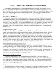
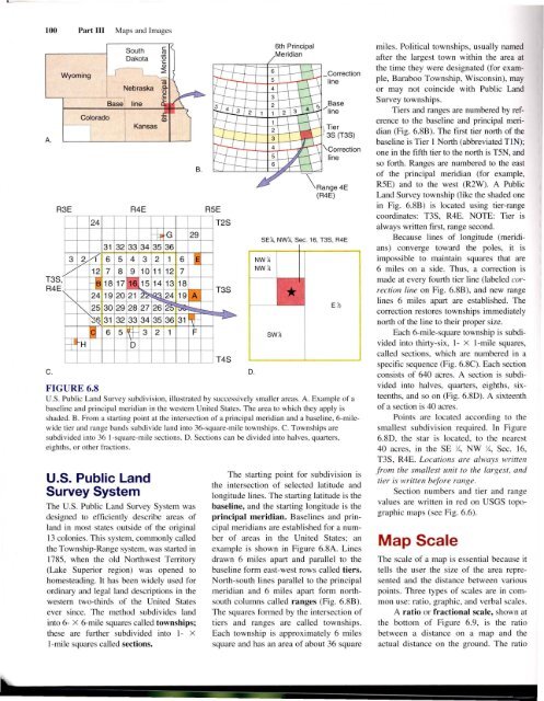
FIGURE 6.8<br />
U.S. Public L<strong>and</strong> Survey subdivision, illustrated by successively smaller areas. A. Example of a<br />
baseline <strong>and</strong> principal meridian in the western United States. The area to which they apply is<br />
shaded. B. From a starting point at the intersection of a principal meridian <strong>and</strong> a baseline, 6-milewide<br />
tier <strong>and</strong> range b<strong>and</strong>s subdivide l<strong>and</strong> into 36-square-mile townships. C. Townships are<br />
subdivided into 36 I-square-mile sections. D. Sections can be divided into halves, quarters,<br />
eighths, or other fractions.<br />
R5E<br />
24 T2S<br />
~ G 29<br />
31 32 33 34 35 36<br />
3 ?- /( 6 5 4 3 2 1 6 lE<br />
V 12 7 8 9 10 11 12 7<br />
,<br />
-fa 18 17 16 15 14 13 18<br />
T3S<br />
R4E<br />
~ 24 19 20 21 I~~ 24 19 A<br />
C.<br />
Wyoming<br />
R3E<br />
Base<br />
Colorado<br />
South<br />
Dakota<br />
Nebraska<br />
line<br />
Kansas<br />
T3S<br />
1""- 25 30 29 28 27 26 § ;::::-..<br />
I~ 31 32 33 34 35 36 31 tt-<br />
-?..><br />
:q 6 5 ~ 3 2 1 F<br />
--¥ H 0 T4S<br />
u.s. Public L<strong>and</strong><br />
Survey System<br />
The U.S. Public L<strong>and</strong> Survey System was<br />
designed to efficiently describe areas of<br />
l<strong>and</strong> in most states outside of the original<br />
13 colonies. This system, commonly called<br />
the Township-Range system, was started in<br />
1785, when the old Northwest Tenitory<br />
(Lake Superior region) was opened to<br />
homesteading. It has been widely used for<br />
ordinary <strong>and</strong> legal l<strong>and</strong> descriptions in the<br />
western two-thirds of the United States<br />
ever since. The method subdivides l<strong>and</strong><br />
into 6- X 6-mile squares called townships;<br />
these are further subdivided into 1- X<br />
I-mile squares called sections.<br />
D.<br />
E~<br />
The starting point for subdivision is<br />
the intersection of selected latitude <strong>and</strong><br />
longitude lines. The starting latitude is the<br />
baseline, <strong>and</strong> the starting longitude is the<br />
principal meridian. Baselines <strong>and</strong> principal<br />
meridians are established for a number<br />
of areas in the United States; an<br />
example is shown in Figure 6.8A. Lines<br />
drawn 6 miles apart <strong>and</strong> parallel to the<br />
baseline form east-west rows called tiers.<br />
North-south lines parallel to the principal<br />
meridian <strong>and</strong> 6 miles apart form northsouth<br />
columns called ranges (Fig. 6.8B).<br />
The squares formed by the intersection of<br />
tiers <strong>and</strong> ranges are called townships.<br />
Each township is approximately 6 miles<br />
square <strong>and</strong> has an area of about 36 square<br />
miles. Political townships, usually named<br />
after the largest town within the area at<br />
the time they were designated (for example,<br />
Baraboo Township, Wisconsin), may<br />
or may not coincide with Public L<strong>and</strong><br />
Survey townships.<br />
Tiers <strong>and</strong> ranges are numbered by reference<br />
to the baseline <strong>and</strong> principal meridian<br />
(Fig. 6.8B). The first tier north of the<br />
baseline is Tier 1 North (abbreviated TIN);<br />
one in the fifth tier to the north is T5N, <strong>and</strong><br />
so forth. Ranges are numbered to the east<br />
of the principal meridian (for example,<br />
R5E) <strong>and</strong> to the west (R2W). A Public<br />
L<strong>and</strong> Survey township (like the shaded one<br />
in Fig. 6.8B) is located using tier-range<br />
coordinates: T3S, R4E. NOTE: Tier is<br />
always written first, range second.<br />
Because lines of longitude (meridians)<br />
converge toward the poles, it is<br />
impossible to maintain squares that are<br />
6 miles on a side. Thus, a correction is<br />
made at every fourth tier line (labeled correction<br />
line on Fig. 6.8B), <strong>and</strong> new range<br />
lines 6 miles apart are established. The<br />
cOlTection restores townships immediately<br />
north of the line to their proper size.<br />
Each 6-mile-square township is subdivided<br />
into thirty-six, 1- X I-mile squares,<br />
called sections, which are numbered in a<br />
specific sequence (Fig. 6.8C). Each section<br />
consists of 640 acres. A section is subdivided<br />
into halves, quarters, eighths, sixteenths,<br />
<strong>and</strong> so on (Fig. 6.8D). A sixteenth<br />
of a section is 40 acres.<br />
Points are located according to the<br />
smallest subdivision required. In Figure<br />
6.8D, the star is located, to the nearest<br />
40 acres, in the SE )4, NW )4, Sec. 16,<br />
T3S, R4E. Locations are always written<br />
from the smallest unit to the largest, <strong>and</strong><br />
tier is written before range.<br />
Section numbers <strong>and</strong> tier <strong>and</strong> range<br />
values are written in red on USGS topographic<br />
maps (see Fig. 6.6).<br />
Map Scale<br />
The scale of a map is essential because it<br />
tells the user the size of the area represented<br />
<strong>and</strong> the distance between various<br />
points. Three types of scales are in common<br />
use: ratio, graphic, <strong>and</strong> verbal scales.<br />
A ratio or fractional scale, shown at<br />
the bottom of Figure 6.9, is the ratio<br />
between a distance on a map <strong>and</strong> the<br />
actual distance on the ground. The ratio