Topographic Maps and Digital Elevation Models
Topographic Maps and Digital Elevation Models
Topographic Maps and Digital Elevation Models

You also want an ePaper? Increase the reach of your titles
YUMPU automatically turns print PDFs into web optimized ePapers that Google loves.
Chapter 6 <strong>Topographic</strong> <strong>Maps</strong> <strong>and</strong> <strong>Digital</strong> Elevaton <strong>Models</strong> 117<br />
7. Where is the magnetic north pole today? Magnetic north is always on the move. The Canadian Geologic<br />
Survey has set up a nice website (gsc.nrcan.gc.ca/geomag/nmp/northpole e.php) showing the magnetic north<br />
pole's current <strong>and</strong> past positions on its journey through northern Canada. It explains why variations occur on<br />
daily <strong>and</strong> yearly time scales <strong>and</strong> projects the future locations of the magnetic north pole. It is worth taking a<br />
moment to check out this web site.<br />
In Greater Depth<br />
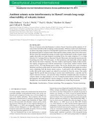
8. Plan a hiking excursion: British Columbia offers some of the most rugged scenery in North America. If you like hiking,<br />
leafing through a stack of Canadian topographic maps will inspire daydreams of amazing wilderness experiences (if you avoid<br />
the many logged out areas, that is!). Figure 6.20 shows a portion of the Wells Gray Provincial Park in central BC This park is<br />
in the Cariboo Mountains, which are part of the Columbia Mountains. The blue lines <strong>and</strong> numbers define the I-km UTM grid.<br />
The map symbols are similar to those of USGS maps (Fig. 6.10); the actual map key is h<strong>and</strong>ily printed on the back of the<br />
original map.<br />
Let's say your goal in visiting this part of the park is to combine geologic exploration with back-country hiking. To get there,<br />
you portage 13 km from a lake to the south <strong>and</strong> paddle some 25 km until you reach the end of Hobson Lake, the large lake<br />
shown in the southwestern corner of Figure 6.20. For more information <strong>and</strong> photos, visit www.wellsgray.ca.<br />
a. First off, most of the map area is covered in green. What does this mean?<br />
b. Your goal is to climb the large hill with a number of lakes on its top (near "FP GP"). What is a representative elevation of<br />
the area with the many small lakes? What is the height of this area relative to the lake that you arrived on?<br />
c. To get to this hilltop, you need to beach your canoe <strong>and</strong> hike. Based on the map symbols, what is the l<strong>and</strong>scape like at the<br />
northeastern end of the lake?<br />
Do you think it would be an easy hike across such a l<strong>and</strong>scape? Why?<br />
d. The edges of established forests, such as along lakes or highways, often SpOt1 a dense undergrowth. Away from the edge,<br />
the undergrowth tends to disappear <strong>and</strong> hiking is easier. In anticipation of this <strong>and</strong> other problems that can effectively block<br />
a path, use the following guidelines to draw three possible paths leading to the lake area on top of the hill. Label each path l<br />
o<br />
o<br />
Path A: Take the shortest route from the lake shore to the hillside. Continue to the hilltop with the lakes via a route that,<br />
while it may be long, follows the gentlest slopes. The goal is to avoid scaling a cliff.<br />
Path B: Take the canoe up East Creek (which drains into Hobson Lake) <strong>and</strong> l<strong>and</strong> where you won't have to worry about<br />
marching through a swamp <strong>and</strong> where you get the most direct route to the lakes without climbing unnecessary elevation.<br />
What is the average slope of your path once it starts up the hill? Express the result in meters per meter.<br />
o<br />
Path C: Take the canoe up Hobson Creek as far as necessary to avoid swampy l<strong>and</strong> <strong>and</strong> to gain access to the gentler<br />
slopes leading to the toe of the hill near the letter "I." Avoid any closely spaced contours that indicate inconveniently<br />
steep slopes, <strong>and</strong> avoid climbing unnecessary elevation on your way to the lakes on the hilltop.<br />
Calculate a typical slope of this path once it starts up the hill from near the letter "1." Express the result in meters per meter.<br />
e. Find the peak with the highest elevation on the hill with lakes <strong>and</strong> mark it with an "X." What is its elevation?