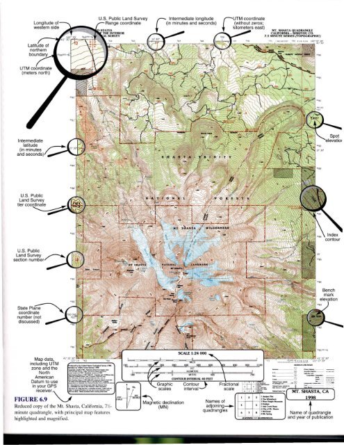
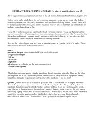
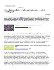
U.S. Public L<strong>and</strong> Survey Range coordinate r Intermediate longitude (in minutes <strong>and</strong> seconds) rUTM coordinate (without zeros; kilometers east) MT. SHASTA QUADRANGLE CAUFORNIA -- SISKIYOU CO. 7.5 MINUTE SERIES (TOPOGRAPHIC) U.S. Public L<strong>and</strong> Survey tiercoo~ U.S. Public L<strong>and</strong> Survey ~ section number/' - StatePla~ coordin~t~" ~ number (not discussed) Map data, including UTM ......-.s-"""'-......'_ zone <strong>and</strong> the '=.~~~":.__ _ \V _ North :2-=::?:::'-:7-_ 1~ 11.5._. 8 =~---- American _....:::-~.::.:.:=..-=.-_"';';' 13 ----- Datum to use ~::.:::=E:.:::r=:-: ...L~~==:::;;:-""""t__;::=:;::'~=~~::::':'::~~=-_;:::±:;:=7"""rrl"'T'J"T'J:~~ .__ 0 ::;"---- --- in your GPS _=~:'::J::.:""':__~. Contour • :::::..-- :::-'::~:-""a ~ ==- FIGUR~e:~;er.\. ~...:=;:...-::.::..-:.:==;=.- ,',:-. ";'':: ~ interval • !~~~-::=C MT. S~A, CA ) "'--J Magnetic declination Names of ,--..- t Reduced copy of the Mt. Shasta, California, 7'/,- (MN) adjoining---... '-----t--+---I~=-- d I r- 6CllyofMt.Sh-. minute quadrangle, with principal map features qua rang es ~~ Name of quadrangle highlighted <strong>and</strong> magnified. """'""""". <strong>and</strong> year of publication 101Xll
102 Part III <strong>Maps</strong> <strong>and</strong> Images scale on Figure 6.9 is I:24,000 (or 1124,000), which means that one unit (for example, an inch) on the map equals 24,000 of the same units on the ground. A graphic scale usually consists of a scale bar subdivided into divisions corresponding to a mile or kilometer (see Fig. 6.9). One mile or kilometer segment on the scale bar is commonly subdivided to allow more precise measurements of distance. The subdivided units are commonly placed to the left of zero on a scale bar, as in Figure 6.9. A graphic scale is helpful because it is readily visualized <strong>and</strong> stays in true proportion if the map is enlarged or reduced. It also provides a convenient way of measuring distances between points on a map: lay a strip of paper between the points <strong>and</strong> make pencil marks next to each point. Then lay the paper along the graphic scale at the bottom of the map <strong>and</strong> determine the distance. A verbal scale is commonly used to discuss maps but is rarely written on them. People usually say, "I inch equals I mile," which means, "I inch on the map represents, or is proportional to, 1 mile on the ground." Because I mile equals 63,360 inches, a common fractional scale of 1:62,500 on older maps corresponds closely to the verbal scale "I inch to I mile." Many U.S. maps, <strong>and</strong> essentially all foreign maps, use metric scales, making common fractional scales easily convertible to verbal scales: scales of I:50,000, I: 100000, <strong>and</strong> I:250,000 correspond to I centimeter equaling 0.5, 1.0, <strong>and</strong> 2.5 kilometers, respectively. 4° quadrangle maps are drawn at a fractional scale of I: I,000,000; 2° quadrangles at I:500,000; I° at I:250,000; 15' at I:62,500 or I:50,000; <strong>and</strong> 7'.1.' at 1:24,000 or 1:25,000. Both graphic <strong>and</strong> fractional scales are shown at the bottom center of the map (see Fig. 6.9). These different scales are used to show larger or smaller areas of the Earth's surface on conveniently sized maps. For example, it may be possible to show a small city on a map where I inch on the map represents 12,000 inches (1000 ft) on the ground. This map would have a scale of I: 12,000. However, to show a midsized state, such as Indiana, on a map of similar size, the scale would have to be much smaller, say I inch on the map to 500,000 inches (approximately 8 miles) on the ground. In general, the larger the area shown, the smaller the scale of the map (smaller because the fraction 1!500,000 is a smaller number than 1/12,000). Converting Among Scales Verbal to fractional scale conversion: I. Convert map <strong>and</strong> ground distances to the same units. 2. Write the verbal scale as the fraction: I. Convert both map <strong>and</strong> ground distances to the same units, inches: 5000 X 12" = 60,000". The verbal scale is now 2.5 inches on the map represents 60,000 inches on the ground. 2. Write the verbal scale as the fraction: 2.5" (distance on map) 60,000" (distance on ground) 3. Divide the numerator <strong>and</strong> denominator by the value of the numerator: 2.5"/2.5" 60,000"/2.5" Distance on map Distance on ground 3. Divide both numerator <strong>and</strong> denominator by the value of the numerator: Distance 0/1 map/distance on map Distance on ground/distance on map Example: Convert the following verbal scale to a fractional scale: 2.5 inches on the map represents 5000 feet on the ground. I 24,000 or 1:24,000 Fractional to verbal scale conversion: I. Select convenient map <strong>and</strong> ground units to relate to each other (for example, inches <strong>and</strong> miles or centimeters <strong>and</strong> kilometers). 2. Express fractional scale using the map units (inches or centimeters). 3. Convert the denominator to the ground units (miles or kilometers). 4. Express verbally as "I inch [or I centimeter] equals X miles [or kilometers]." Example: Convert a fractional scale of I:62,500 to a verbal scale of I map inch equals X miles on the ground. I. Units to be related are inches <strong>and</strong> miles. 2. 1:62,500 = 1"/62,500" 3. Convert 62,500" into miles by dividing by the number of inches in I mile. One mile = 5280 feet <strong>and</strong> 1 foot = 12 inches. So, 1 mi = 5280' X 12" = 63,360". Working out the division: 62,500 inches . 63 360 ' I . = 0.986111/ , mc 1es per 1111 4. Expressed verbally, I inch on the map equals 0.986 mile on the ground. Magnetic Declination <strong>Maps</strong> are usually drawn with north at the top. North on a map refers to true geographic north. At most places on Earth, however, a compass needle does not point toward the geographic north pole but toward the magnetic north pole. The magnetic north pole is in the Canadian Arctic, but its exact position changes. For example, in 1955, it was located north of Prince of Wales Isl<strong>and</strong> near latitude 74° N, longitude 100° W; its last measured location in 200 I put it in the Canadian Arctic Ocean (81.3° N, 110.3° W) headed northwest toward Siberia at 40 km/year. The angular distance between true north <strong>and</strong> magnetic north is the magnetic declination. Because the location of the magnetic pole changes, the magnetic declination generally varies with time. If you are navigating or doing geologic research using a compass, you must adjust the declination of the compass for local conditions. Without adjustment, compass errors in excess of 10° to 20° are possible along the west <strong>and</strong> east coasts of North America! The magnetic declination is shown at the bottom of most USGS maps by two arrows (see Fig. 6.9). One points to true north (commonly marked with a star, or T.N.) <strong>and</strong> one points toward magnetic north (commonly marked M.N.). The