Topographic Maps and Digital Elevation Models
Topographic Maps and Digital Elevation Models
Topographic Maps and Digital Elevation Models

Create successful ePaper yourself
Turn your PDF publications into a flip-book with our unique Google optimized e-Paper software.
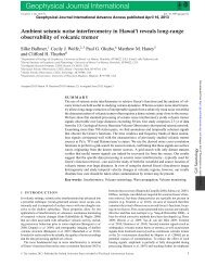
102 Part III <strong>Maps</strong> <strong>and</strong> Images<br />
scale on Figure 6.9 is I:24,000 (or<br />
1124,000), which means that one unit (for<br />
example, an inch) on the map equals<br />
24,000 of the same units on the ground.<br />
A graphic scale usually consists of a<br />
scale bar subdivided into divisions corresponding<br />
to a mile or kilometer (see Fig.<br />
6.9). One mile or kilometer segment on<br />
the scale bar is commonly subdivided to<br />
allow more precise measurements of distance.<br />
The subdivided units are commonly<br />
placed to the left of zero on a scale bar, as<br />
in Figure 6.9. A graphic scale is helpful<br />
because it is readily visualized <strong>and</strong> stays<br />
in true proportion if the map is enlarged or<br />
reduced. It also provides a convenient way<br />
of measuring distances between points on<br />
a map: lay a strip of paper between the<br />
points <strong>and</strong> make pencil marks next to<br />
each point. Then lay the paper along the<br />
graphic scale at the bottom of the map <strong>and</strong><br />
determine the distance.<br />
A verbal scale is commonly used to<br />
discuss maps but is rarely written on<br />
them. People usually say, "I inch equals<br />
I mile," which means, "I inch on the map<br />
represents, or is proportional to, 1 mile<br />
on the ground." Because I mile equals<br />
63,360 inches, a common fractional scale<br />
of 1:62,500 on older maps corresponds<br />
closely to the verbal scale "I inch to<br />
I mile." Many U.S. maps, <strong>and</strong> essentially<br />
all foreign maps, use metric scales, making<br />
common fractional scales easily convertible<br />
to verbal scales: scales of<br />
I:50,000, I: 100000, <strong>and</strong> I:250,000 correspond<br />
to I centimeter equaling 0.5, 1.0,<br />
<strong>and</strong> 2.5 kilometers, respectively.<br />
4° quadrangle maps are drawn at a<br />
fractional scale of I: I,000,000; 2° quadrangles<br />
at I:500,000; I° at I:250,000; 15' at<br />
I:62,500 or I:50,000; <strong>and</strong> 7'.1.' at 1:24,000<br />
or 1:25,000. Both graphic <strong>and</strong> fractional<br />
scales are shown at the bottom center of the<br />
map (see Fig. 6.9).<br />
These different scales are used to<br />
show larger or smaller areas of the Earth's<br />
surface on conveniently sized maps. For<br />
example, it may be possible to show a<br />
small city on a map where I inch on the<br />
map represents 12,000 inches (1000 ft) on<br />
the ground. This map would have a scale<br />
of I: 12,000. However, to show a midsized<br />
state, such as Indiana, on a map of<br />
similar size, the scale would have to be<br />
much smaller, say I inch on the map to<br />
500,000 inches (approximately 8 miles) on<br />
the ground. In general, the larger the area<br />
shown, the smaller the scale of the map<br />
(smaller because the fraction 1!500,000 is<br />
a smaller number than 1/12,000).<br />
Converting Among<br />
Scales<br />
Verbal to fractional scale<br />
conversion:<br />
I. Convert map <strong>and</strong> ground distances<br />
to the same units.<br />
2. Write the verbal scale as the fraction:<br />
I. Convert both map <strong>and</strong> ground distances<br />
to the same units, inches:<br />
5000 X 12" = 60,000". The verbal<br />
scale is now 2.5 inches on the map<br />
represents 60,000 inches on the<br />
ground.<br />
2. Write the verbal scale as the fraction:<br />
2.5" (distance on map)<br />
60,000" (distance on ground)<br />
3. Divide the numerator <strong>and</strong> denominator<br />
by the value of the numerator:<br />
2.5"/2.5"<br />
60,000"/2.5"<br />
Distance on map<br />
Distance on ground<br />
3. Divide both numerator <strong>and</strong> denominator<br />
by the value of the numerator:<br />
Distance 0/1 map/distance on map<br />
Distance on ground/distance on map<br />
Example: Convert the following verbal<br />
scale to a fractional scale: 2.5 inches on<br />
the map represents 5000 feet on the<br />
ground.<br />
I<br />
24,000 or 1:24,000<br />
Fractional to verbal scale<br />
conversion:<br />
I. Select convenient map <strong>and</strong> ground<br />
units to relate to each other (for<br />
example, inches <strong>and</strong> miles or centimeters<br />
<strong>and</strong> kilometers).<br />
2. Express fractional scale using the<br />
map units (inches or centimeters).<br />
3. Convert the denominator to the<br />
ground units (miles or kilometers).<br />
4. Express verbally as "I inch [or<br />
I centimeter] equals X miles [or<br />
kilometers]."<br />
Example: Convert a fractional scale of<br />
I:62,500 to a verbal scale of I map inch<br />
equals X miles on the ground.<br />
I. Units to be related are inches <strong>and</strong><br />
miles.<br />
2. 1:62,500 = 1"/62,500"<br />
3. Convert 62,500" into miles by dividing<br />
by the number of inches in<br />
I mile. One mile = 5280 feet <strong>and</strong><br />
1 foot = 12 inches. So, 1 mi =<br />
5280' X 12" = 63,360". Working<br />
out the division:<br />
62,500 inches .<br />
63 360 ' I . = 0.986111/<br />
, mc 1es per 1111<br />
4. Expressed verbally, I inch on the<br />
map equals 0.986 mile on the<br />
ground.<br />
Magnetic<br />
Declination<br />
<strong>Maps</strong> are usually drawn with north at<br />
the top. North on a map refers to true<br />
geographic north. At most places on<br />
Earth, however, a compass needle does<br />
not point toward the geographic north<br />
pole but toward the magnetic north pole.<br />
The magnetic north pole is in the<br />
Canadian Arctic, but its exact position<br />
changes. For example, in 1955, it was<br />
located north of Prince of Wales Isl<strong>and</strong><br />
near latitude 74° N, longitude 100° W;<br />
its last measured location in 200 I put it<br />
in the Canadian Arctic Ocean (81.3° N,<br />
110.3° W) headed northwest toward<br />
Siberia at 40 km/year.<br />
The angular distance between true<br />
north <strong>and</strong> magnetic north is the magnetic<br />
declination. Because the location<br />
of the magnetic pole changes, the magnetic<br />
declination generally varies with<br />
time. If you are navigating or doing geologic<br />
research using a compass, you<br />
must adjust the declination of the compass<br />
for local conditions. Without<br />
adjustment, compass errors in excess of<br />
10° to 20° are possible along the west<br />
<strong>and</strong> east coasts of North America! The<br />
magnetic declination is shown at the<br />
bottom of most USGS maps by two<br />
arrows (see Fig. 6.9). One points to true<br />
north (commonly marked with a star, or<br />
T.N.) <strong>and</strong> one points toward magnetic<br />
north (commonly marked M.N.). The