Topographic Maps and Digital Elevation Models
Topographic Maps and Digital Elevation Models
Topographic Maps and Digital Elevation Models

Create successful ePaper yourself
Turn your PDF publications into a flip-book with our unique Google optimized e-Paper software.
Chapter 6 <strong>Topographic</strong> <strong>Maps</strong> <strong>and</strong> <strong>Digital</strong> Elevaton <strong>Models</strong> 97<br />
also important if you plan on taking a<br />
GIS class in the future.<br />
Map Coordinates<br />
<strong>and</strong> L<strong>and</strong><br />
Subdivision<br />
Coordinate systems provide a permanent<br />
way of describing locations. For example,<br />
older descriptions of mineral or fossil sites<br />
commonly refer to l<strong>and</strong>marks. Unfortunately,<br />
some of these old sites are now lost<br />
because road intersections, houses, small<br />
bridges, old trees, <strong>and</strong> railway lines have<br />
since been moved or removed due to<br />
ongoing development. A coordinate system<br />
allows a state to efficiently <strong>and</strong> pennanently<br />
keep track of the locations of ab<strong>and</strong>oned<br />
oil wells, toxic waste sites, sealed<br />
mine shafts, <strong>and</strong> places hosting endangered<br />
plants or breeding pairs. It allows<br />
geologists to describe important rock<br />
localities, <strong>and</strong> it allows hikers to precisely<br />
locate trailheads, remote camp sites, <strong>and</strong><br />
other places worth remembering.<br />
Latitude-Longitude<br />
System<br />
The most well-known global coordinate<br />
system is based on east-west lines called<br />
lines of latitude <strong>and</strong> north-south lines<br />
called lines of longitude.<br />
Latitude measures distance north or<br />
south of the equator. The lines of latitude,<br />
also called parallels, form a series of parallel<br />
circles running east-west (horizontally)<br />
around the globe. The equator represents<br />
the 0° latitude line. Other parallels<br />
are set at angular intervals measured<br />
north or south of the equator, as shown in<br />
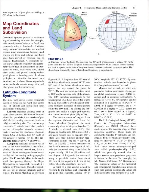
Figure 6.5A. A latitude line 40° north of<br />
the equator is termed 40° N. The geographic<br />
poles are at 90° <strong>and</strong> 90° S.<br />
Longitude measures distance east or<br />
west of the Prime Meridian. Lines of longitude,<br />
also termed meridians, form a<br />
series of circles running north-south (vertically)<br />
<strong>and</strong> intersecting at the geographic<br />
poles. The Prime Meridian is the northsouth<br />
line passing through the Royal<br />
Observatory in Greenwich, Engl<strong>and</strong>; it is<br />
defined as 0° longitude. The other meridians<br />
are set at angular intervals east or<br />
west of the Prime Meridian, as shown in<br />
A.<br />
Equator<br />