Topographic Maps and Digital Elevation Models
Topographic Maps and Digital Elevation Models
Topographic Maps and Digital Elevation Models

You also want an ePaper? Increase the reach of your titles
YUMPU automatically turns print PDFs into web optimized ePapers that Google loves.
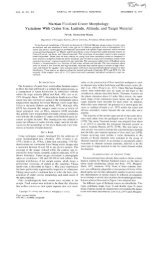
112 Part III <strong>Maps</strong> <strong>and</strong> Images<br />
FIGURE 6.17<br />
Portion of the Walker Lake (north half) <strong>and</strong> Mariposa (south half), CA, I° by 2° quadrangles for use in<br />
Problem 3.<br />
Original scale 1:250,000<br />
C.1. 200 feet<br />
clutter <strong>and</strong>, because they are based on the highest resolution maps available, they can show both broad features <strong>and</strong> fine<br />
detail, even when covering a large area. Use Figures 6.17 <strong>and</strong> 6.18 to answer the following questions:<br />
Only fresh water flows into Mono Lake, but Mono Lake itself is very salty. Why is this? Hint: Do you see any stream leaving<br />
Mono Lake?<br />
Since 1850, lake levels have fluctuated between 6428 feet (1919) <strong>and</strong> 6372 feet (1982). Has Black Point been an isl<strong>and</strong> at<br />
any time since 1850?