Cloud Statistics from Calipso Lidar Data for the ... - espace-tum.de
Cloud Statistics from Calipso Lidar Data for the ... - espace-tum.de
Cloud Statistics from Calipso Lidar Data for the ... - espace-tum.de

Create successful ePaper yourself
Turn your PDF publications into a flip-book with our unique Google optimized e-Paper software.
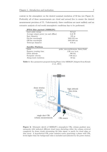
Chapter 1. Introduction and motivation 7<br />
content in <strong>the</strong> atmosphere on <strong>the</strong> <strong>de</strong>sired nominal resolution of 50 km (see Figure 2).<br />
Preferably all of <strong>the</strong>se measurements are cloud and aerosol free to ensure <strong>the</strong> <strong>de</strong>sired<br />
measurement precision of 1%. Un<strong>for</strong>tunately, <strong>the</strong>se conditions are most unlikely and an<br />
extensive analysis of real world atmospheric conditions has to be per<strong>for</strong>med.<br />
IPDA lidar payload (MERLIN)<br />
Laser pulse energy<br />
Average output power (on and offline)<br />
Spot diameter<br />
On-line wavelength<br />
Off-line wavelength<br />
Telescope diameter<br />
Satellite Plat<strong>for</strong>m<br />
Orbit<br />
Equator crossing time<br />
Orbit altitu<strong>de</strong><br />
Footprint velocity<br />
Along-track resolution<br />
9.0 mJ<br />
0.45 W<br />
135 m<br />
1645.552 nm<br />
1645.846 nm<br />
0.55 m<br />
polar, sun-synchronous, dawn/dusk<br />
1:30 a.m./p.m.<br />
506 km<br />
7.06 km/s<br />
50 km<br />
Table 1: Key parameters proposed during Phase A <strong>for</strong> MERLIN [Adapted <strong>from</strong> Kiemle<br />
et al., 2011]<br />
<strong>de</strong>nse stratus<br />
cumulus<br />
high altitu<strong>de</strong><br />
thin cirrus<br />
single shot CH4<br />
column measurements<br />
CH4 source<br />
Figure 2: Schematic sketch of MERLIN’s atmospheric CH 4 column gradient measurements<br />
with indicated different cloud types disturbing ei<strong>the</strong>r <strong>the</strong> column retrieval<br />
completely <strong>for</strong> <strong>de</strong>nse clouds attenuating <strong>the</strong> lidar signal, or partly <strong>for</strong> cloud edges or<br />
thin cirrus. A hypo<strong>the</strong>tical CH 4 point emission source generating a plume with CH 4<br />
levels higher than <strong>the</strong> background value is inclu<strong>de</strong>d and indicated by <strong>the</strong> power station.