Cloud Statistics from Calipso Lidar Data for the ... - espace-tum.de
Cloud Statistics from Calipso Lidar Data for the ... - espace-tum.de
Cloud Statistics from Calipso Lidar Data for the ... - espace-tum.de

You also want an ePaper? Increase the reach of your titles
YUMPU automatically turns print PDFs into web optimized ePapers that Google loves.
Chapter 4. Case studies 37<br />
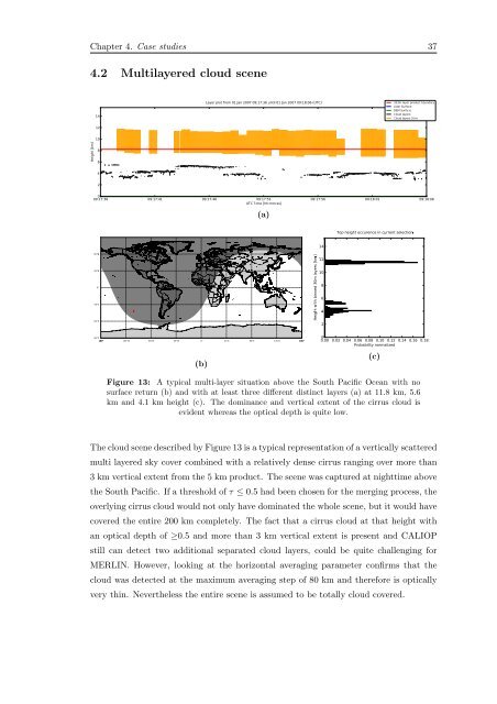
4.2 Multilayered cloud scene<br />
14<br />
12<br />
Layer plot <strong>from</strong> 01 Jan 2007 09:17:36 until 01 Jan 2007 09:18:06 (UTC)<br />
333m layer product boundary<br />
<strong>Lidar</strong> Surface<br />
DEM Surface<br />
<strong>Cloud</strong> layers<br />
<strong>Cloud</strong> layers 5km<br />
10<br />
Height [km]<br />
8<br />
6<br />
4<br />
2<br />
0<br />
09:17:36 09:17:41 09:17:46 09:17:51 09:17:56 09:18:01 09:18:06<br />
UTC Time [hh:mm:ss]<br />
(a)<br />
Top height occurence in current selection<br />
14<br />
Height with binned 30m layers [km]<br />
12<br />
10<br />
8<br />
6<br />
4<br />
2<br />
(b)<br />
0<br />
0.00 0.02 0.04 0.06 0.08 0.10 0.12 0.14 0.16 0.18<br />
Probability normalized<br />
(c)<br />
Figure 13: A typical multi-layer situation above <strong>the</strong> South Pacific Ocean with no<br />
surface return (b) and with at least three different distinct layers (a) at 11.8 km, 5.6<br />
km and 4.1 km height (c). The dominance and vertical extent of <strong>the</strong> cirrus cloud is<br />
evi<strong>de</strong>nt whereas <strong>the</strong> optical <strong>de</strong>pth is quite low.<br />
The cloud scene <strong>de</strong>scribed by Figure 13 is a typical representation of a vertically scattered<br />
multi layered sky cover combined with a relatively <strong>de</strong>nse cirrus ranging over more than<br />
3 km vertical extent <strong>from</strong> <strong>the</strong> 5 km product. The scene was captured at nighttime above<br />
<strong>the</strong> South Pacific. If a threshold of τ ≤ 0.5 had been chosen <strong>for</strong> <strong>the</strong> merging process, <strong>the</strong><br />
overlying cirrus cloud would not only have dominated <strong>the</strong> whole scene, but it would have<br />
covered <strong>the</strong> entire 200 km completely. The fact that a cirrus cloud at that height with<br />
an optical <strong>de</strong>pth of ≥0.5 and more than 3 km vertical extent is present and CALIOP<br />
still can <strong>de</strong>tect two additional separated cloud layers, could be quite challenging <strong>for</strong><br />
MERLIN. However, looking at <strong>the</strong> horizontal averaging parameter confirms that <strong>the</strong><br />
cloud was <strong>de</strong>tected at <strong>the</strong> maximum averaging step of 80 km and <strong>the</strong>re<strong>for</strong>e is optically<br />
very thin. Never<strong>the</strong>less <strong>the</strong> entire scene is assumed to be totally cloud covered.