Cloud Statistics from Calipso Lidar Data for the ... - espace-tum.de
Cloud Statistics from Calipso Lidar Data for the ... - espace-tum.de
Cloud Statistics from Calipso Lidar Data for the ... - espace-tum.de

Create successful ePaper yourself
Turn your PDF publications into a flip-book with our unique Google optimized e-Paper software.
Chapter 3. Methodology behind cloud free and cloud gap statistics 30<br />
5km<br />
MERGING<br />
ALGORITHM<br />
+8.22 km<br />
1 km<br />
2 km<br />
7 km<br />
0 0 0 0 0 0 1 1 1 0 0 0 0 0 0 0 0 0 1 1 1 1 1 1 0 0 0<br />
0 0 0 0 0 0 2 2 2 1 1 1 1 1 1 1 1 1 2 2 2 1 1 1 0 0 0<br />
Ground<br />
Number Layers Found in 333 m<br />
Number Layers Found in merged data set<br />
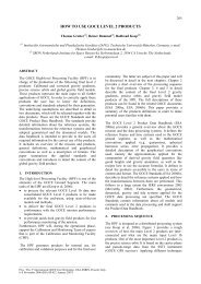
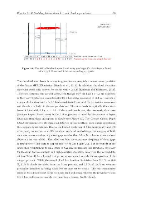
Figure 10: The 333 m Number Layers Found array gets larger if a cloud layer is found<br />
with z t ≥ 8.22 km and if <strong>the</strong> corresponding τ col ≥ 0.5.<br />
The threshold was chosen in a way to guarantee an acceptable measurement precision<br />
of <strong>the</strong> future MERLIN mission [Kiemle et al., 2011]. In addition, <strong>the</strong> cloud <strong>de</strong>tection<br />
algorithm works only correct <strong>for</strong> clouds with τ ≥ 0.45 [Karlsson and Johansson, 2013].<br />
There<strong>for</strong>e, optically thin aerosol layers, even though <strong>the</strong>y can have τ > 0.5 are neglected<br />
as <strong>the</strong>ir corret <strong>de</strong>tection is questionable <strong>for</strong> a horizontal resolution of 333 m. However if<br />
a single shot feature with τ > 0.5 has been <strong>de</strong>tected it is most likely classified as a cloud<br />
and <strong>the</strong>re<strong>for</strong>e inclu<strong>de</strong>d in <strong>the</strong> merged data set. The same holds <strong>for</strong> optically thin clouds<br />
below 8.2 km with 0.5 < τ < 1.0. If this condition is met, <strong>the</strong> previously cloud free<br />
(Number Layers Found) entry in <strong>the</strong> 333 m product is raised by <strong>the</strong> amount of layers<br />
found and <strong>from</strong> <strong>the</strong>re on appears as cloudy (see Figure 10). The Column Optical Depth<br />
<strong>Cloud</strong> 532 parameter is <strong>the</strong> sum of all <strong>de</strong>tected optical <strong>de</strong>pths of each feature <strong>de</strong>tected in<br />
<strong>the</strong> complete 5 km column. Due to <strong>the</strong> limited resolution of 5 km horizontally and 180<br />
m vertically as well as to a different cloud retrieval methodology, <strong>the</strong> merging of both<br />
data sets cannot consi<strong>de</strong>r any cloud gaps smaller than 5 km <strong>for</strong> columns where a cloud<br />
above 8.2 km was ad<strong>de</strong>d. This effect can bias <strong>the</strong> occurrence frequency of cloud gaps<br />
as multiples of 5 km seem to appear more often (see Figure 21). But <strong>the</strong> benefit of <strong>the</strong><br />
single shot resolution up to an altitu<strong>de</strong> of 8.22 km circumvents this drawback, especially<br />
<strong>for</strong> <strong>the</strong> cloud flatness analysis and high resolution statistics. Analyzing <strong>the</strong> merged data<br />
set (see Table 4) <strong>for</strong> a limited test period of one month reveals <strong>the</strong> composition of <strong>the</strong><br />
merged product. While <strong>the</strong> overall cloud free fraction diminishes <strong>from</strong> 52.1 % to 40.6<br />
%, 11.5 % clouds are ad<strong>de</strong>d <strong>from</strong> <strong>the</strong> 5 km product, and 3.7 % of <strong>the</strong> 5 km columns<br />
previously <strong>de</strong>scribed as being cloud free are now set to cloudy. The less transmissive<br />
layers of <strong>the</strong> 5 km product occur both over land and ocean, whereas <strong>the</strong> previously cloud<br />
free 5 km profiles occur mainly over land (e.g., Sahara, South China).