

Report PDF (3.7 MB) - USGS
Report PDF (3.7 MB) - USGS
Report PDF (3.7 MB) - USGS

You also want an ePaper? Increase the reach of your titles
YUMPU automatically turns print PDFs into web optimized ePapers that Google loves.
Prepared in cooperation with the U.S. Army Corps of Engineers<br />
Use of Surrogate Technologies to Estimate Suspended<br />
Sediment in the Clearwater River, Idaho, and Snake River,<br />
Washington, 2008–10<br />
Scientific Investigations <strong>Report</strong> 2013-5052<br />
U.S. Department of the Interior<br />
U.S. Geological Survey
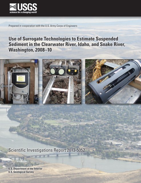
Cover:<br />
Background: Confluence of the Snake and Clearwater Rivers at Lewiston, Idaho, May 14, 2012.<br />
From left to right<br />
Inset 1: Laser In Situ Scattering and Transmissometry (LISST)-Streamside laser diffraction instrument—Clearwater River at Spalding, Idaho, March 19, 2009.<br />
Inset 2: Acoustic Doppler velocity meters (ADVMs)—Snake River near Anatone, Washington, March 20, 2009.<br />
Inset 3: Nephelometric turbidity probe—Clearwater River at Spalding, Idaho, May 7, 2008.<br />
All photographs were taken by Molly Wood, U.S. Geological Survey.
Use of Surrogate Technologies to Estimate<br />
Suspended Sediment in the Clearwater River,<br />
Idaho, and Snake River, Washington, 2008–10<br />
By Molly S. Wood, U.S. Geological Survey, and Gregg N. Teasdale, U.S. Army<br />
Corps of Engineers<br />
Prepared in cooperation with the U.S. Army Corps of Engineers<br />
Scientific Investigations <strong>Report</strong> 2013–5052<br />
U.S. Department of the Interior<br />
U.S. Geological Survey
U.S. Department of the Interior<br />
KEN SALAZAR, Secretary<br />
U.S. Geological Survey<br />
Suzette M. Kimball, Acting Director<br />
U.S. Geological Survey, Reston, Virginia: 2013<br />
For more information on the <strong>USGS</strong>—the Federal source for science about the Earth, its natural and living<br />
resources, natural hazards, and the environment, visit http://www.usgs.gov or call 1–888–ASK–<strong>USGS</strong>.<br />
For an overview of <strong>USGS</strong> information products, including maps, imagery, and publications,<br />
visit http://www.usgs.gov/pubprod<br />
To order this and other <strong>USGS</strong> information products, visit http://store.usgs.gov<br />
Any use of trade, firm, or product names is for descriptive purposes only and does not imply endorsement by the<br />
U.S. Government.<br />
Although this information product, for the most part, is in the public domain, it also may contain copyrighted materials<br />
as noted in the text. Permission to reproduce copyrighted items must be secured from the copyright owner.<br />
Suggested citation:<br />
Wood, M.S., and Teasdale, G.N., 2013, Use of surrogate technologies to estimate suspended sediment in the<br />
Clearwater River, Idaho, and Snake River, Washington, 2008–10: U.S. Geological Survey Scientific Investigations<br />
<strong>Report</strong> 2013-5052, 30 p.
iii<br />
Contents<br />
Abstract ...........................................................................................................................................................1<br />
Introduction.....................................................................................................................................................1<br />
Background............................................................................................................................................3<br />
Site Descriptions and Surrogate Instrument Configurations..................................................................4<br />
Clearwater River Study Site.................................................................................................................4<br />
Snake River Study Site..........................................................................................................................6<br />
Methods...........................................................................................................................................................8<br />
Sediment Sample Collection................................................................................................................8<br />
Surrogate Instrument Data Corrections............................................................................................9<br />
Acoustic Data Corrections..........................................................................................................9<br />
Acoustic Beam Spreading.................................................................................................9<br />
Acoustic Absorption by Water........................................................................................10<br />
Acoustic Absorption by Sediment..................................................................................11<br />
Surrogate Model Development.........................................................................................................11<br />
Use of Surrogate Models To Estimate Suspended Sediment................................................................12<br />
Clearwater River Study Site...............................................................................................................12<br />
Snake River Study Site........................................................................................................................18<br />
Advantages of Acoustics over Sediment-Transport Curves in Sediment Monitoring.............21<br />
Comparison over Short Time Scales.......................................................................................21<br />
Comparison over Annual Time Scales....................................................................................26<br />
Summary and Conclusions..........................................................................................................................27<br />
Acknowledgments........................................................................................................................................27<br />
References Cited..........................................................................................................................................27<br />
Figures<br />
1. Map showing study area and locations of sediment surrogate and U.S.<br />
Geological Survey (<strong>USGS</strong>) streamgage sites in the Clearwater River, Idaho, and<br />
Snake River, Washington, May 2008–September 2010............................................................2<br />
2. Photograph showing sediment surrogate instruments deployed at the<br />
Clearwater River near Spalding, Idaho......................................................................................5<br />
3. Photographs showing sediment surrogate instruments deployed at the Snake<br />
River near Anatone, Washington................................................................................................6<br />
4. Graph showing process for calculation of range-normalized acoustic<br />
backscatter corrected for two-way transmission losses in the Clearwater River,<br />
Idaho, and Snake River, Washington........................................................................................10<br />
5. Graph showing surrogate regression models for total suspended sediment,<br />
sand, and fines concentrations based on acoustic backscatter for the<br />
Clearwater River near Spalding, Idaho....................................................................................15<br />
6. Graph showing measured and estimated total suspended sediment<br />
concentrations in the Clearwater River at Spalding, Idaho, based on a surrogate<br />
model with acoustic backscatter..............................................................................................16
iv<br />
Figures—Continued<br />
7. Graph showing estimated instantaneous values of total suspended-sediment<br />
concentration for March 23–July 1, 2010, in the Clearwater River near Spalding,<br />
Idaho, based on a surrogate model with acoustic backscatter and sedimenttransport<br />
curves developed using data from the 2008–10 and 1970s studies...................17<br />
8. Graph showing surrogate regression models for total suspended sediment,<br />
sand, and fines concentrations based on acoustic backscatter for the Snake<br />
River near Anatone, Washington..............................................................................................18<br />
9. Graph showing measured and estimated total suspended-sediment<br />
concentrations in the Snake River near Anatone, Washington, based on a<br />
surrogate model with acoustic backscatter...........................................................................19<br />
10. Graph showing estimated instantaneous values of suspended-sediment<br />
concentration during a storm event on June 1–15, 2010, in the Snake River near<br />
Anatone, Washington, based on a surrogate model with acoustic backscatter<br />
and sediment transport curves developed using data from the 2008–10 and 1970s<br />
studies...........................................................................................................................................20<br />
11. Boxplots showing distribution of total suspended-sediment concentration by<br />
month in the Clearwater River at Spalding, Idaho, based on (A) a surrogate<br />
model with 3MHz acoustic backscatter, (B) 2008–10 sediment transport curves,<br />
and (C) 1970s sediment transport curves, May 2008–September 2010..............................22<br />
12. Graphs showing total suspended-sediment load by month based on a surrogate<br />
model with acoustic backscatter and 2008–10 and 1970s sediment-transport<br />
curves for the (A) Clearwater River at Spalding, Idaho, May 2008–September<br />
2010, and (B) Snake River near Anatone, Washington, April 2009–September<br />
2010................................................................................................................................................24<br />
Tables<br />
1. Suspended-sediment and streamflow data collected in the Clearwater River,<br />
Idaho, and Snake River, Washington, May 2008–September 2010 ......................................8<br />
2. Surrogate model results and regression statistics for the Clearwater River at<br />
Spalding, Idaho, May 2008–September 2010..........................................................................13<br />
3. Surrogate model results and regression statistics for the Snake River near<br />
Anatone, Washington, May 2008–September 2010...............................................................14<br />
4. Comparison of suspended sediment loads during selected storm events<br />
estimated using acoustic backscatter and sediment-transport curves based on<br />
2008–10 streamflows in the Clearwater River at Spalding, Idaho, and Snake<br />
River near Anatone, Washington..............................................................................................25<br />
5. Comparison of total, daily, and annual suspended sediment loads estimated<br />
using acoustic backscatter and sediment-transport curves based on 2008–10<br />
and 1970s streamflows in the Clearwater River at Spalding, Idaho, and Snake<br />
River near Anatone, Washington..............................................................................................26
v<br />
Conversion Factors and Datums<br />
Conversion Factors<br />
Inch/Pound to SI<br />
Multiply By To obtain<br />
Length<br />
foot (ft) 0.3048 meter (m)<br />
mile (mi) 1.609 kilometer (km)<br />
Area<br />
square mile (mi 2 ) 259.0 hectare (ha)<br />
square mile (mi 2 ) 2.590 square kilometer (km 2 )<br />
Flow rate<br />
foot per second (ft/s) 0.3048 meter per second (m/s)<br />
cubic foot per second (ft 3 /s) 0.02832 cubic meter per second (m 3 /s)<br />
Mass<br />
ton, short (2,000 lb) 0.9072 megagram (Mg)<br />
ton per day (ton/d) 0.9072 metric ton per day<br />
ton per day (ton/d) 0.9072 megagram per day (Mg/d)<br />
ton per year (ton/yr) 0.9072 megagram per year (Mg/yr)<br />
ton per year (ton/yr) 0.9072 metric ton per year<br />
Pressure<br />
atmosphere, standard (atm) 101.3 kilopascal (kPa)<br />
pound-force per square inch (lbf/in 2 ) 6.895 kilopascal (kPa)<br />
pound per square foot (lb/ft 2 ) 0.04788 kilopascal (kPa)<br />
pound per square inch (lb/in 2 ) 6.895 kilopascal (kPa)
vi<br />
Conversion Factors and Datums—Continued<br />
Conversion Factors—Continued<br />
SI to Inch/Pound<br />
Multiply By To obtain<br />
Length<br />
centimeter (cm) 0.3937 inch (in.)<br />
meter (m) 3.281 foot (ft)<br />
Volume<br />
liter (L) 33.82 ounce, fluid (fl. oz)<br />
liter (L) 2.113 pint (pt)<br />
liter (L) 1.057 quart (qt)<br />
liter (L) 0.2642 gallon (gal)<br />
liter (L) 61.02 cubic inch (in 3 )<br />
Flow rate<br />
centimeter per second (cm/s) 0.03281 foot per second (ft/s)<br />
centimeter per second (cm/s) 0.03281 foot per second (ft/s)<br />
Mass<br />
gram (g) 0.03527 ounce, avoirdupois (oz)<br />
kilogram (kg) 2.205 pound avoirdupois (lb)<br />
Density<br />
kilogram per cubic meter (kg/m 3 ) 0.06242 pound per cubic foot (lb/ft 3 )<br />
gram per cubic centimeter (g/cm 3 ) 62.4220 pound per cubic foot (lb/ft 3 )<br />
Temperature in degrees Celsius (°C) may be converted to degrees Fahrenheit (°F) as follows:<br />
°F=(1.8×°C)+32.<br />
Temperature in degrees Fahrenheit (°F) may be converted to degrees Celsius (°C) as follows:<br />
Datums<br />
°C=(°F-32)/1.8.<br />
Vertical coordinate information is referenced to the North American Vertical Datum of 1988<br />
(NAVD 88).<br />
Horizontal coordinate information is referenced to the North American Datum of 1983 (NAD 83).<br />
Altitude, as used in this report, refers to distance above the vertical datum.
Use of Surrogate Technologies to Estimate Suspended<br />
Sediment in the Clearwater River, Idaho, and Snake River,<br />
Washington, 2008–10<br />
By Molly S. Wood, U.S. Geological Survey, and Gregg N. Teasdale, U.S. Army Corps of Engineers<br />
Abstract<br />
Elevated levels of fluvial sediment can reduce the<br />
biological productivity of aquatic systems, impair freshwater<br />
quality, decrease reservoir storage capacity, and decrease the<br />
capacity of hydraulic structures. The need to measure fluvial<br />
sediment has led to the development of sediment surrogate<br />
technologies, particularly in locations where streamflow<br />
alone is not a good estimator of sediment load because of<br />
regulated flow, load hysteresis, episodic sediment sources, and<br />
non-equilibrium sediment transport. An effective surrogate<br />
technology is low maintenance and sturdy over a range of<br />
hydrologic conditions, and measured variables can be modeled<br />
to estimate suspended-sediment concentration (SSC), load,<br />
and duration of elevated levels on a real-time basis. Among<br />
the most promising techniques is the measurement of acoustic<br />
backscatter strength using acoustic Doppler velocity meters<br />
(ADVMs) deployed in rivers. The U.S. Geological Survey,<br />
in cooperation with the U.S. Army Corps of Engineers, Walla<br />
Walla District, evaluated the use of acoustic backscatter,<br />
turbidity, laser diffraction, and streamflow as surrogates for<br />
estimating real-time SSC and loads in the Clearwater and<br />
Snake Rivers, which adjoin in Lewiston, Idaho, and flow into<br />
Lower Granite Reservoir. The study was conducted from May<br />
2008 to September 2010 and is part of the U.S. Army Corps<br />
of Engineers Lower Snake River Programmatic Sediment<br />
Management Plan to identify and manage sediment sources in<br />
basins draining into lower Snake River reservoirs.<br />
Commercially available acoustic instruments have<br />
shown great promise in sediment surrogate studies because<br />
they require little maintenance and measure profiles of the<br />
surrogate parameter across a sampling volume rather than at a<br />
single point. The strength of acoustic backscatter theoretically<br />
increases as more particles are suspended in the water to<br />
reflect the acoustic pulse emitted by the ADVM. ADVMs of<br />
different frequencies (0.5, 1.5, and 3 Megahertz) were tested<br />
to target various sediment grain sizes. Laser diffraction and<br />
turbidity also were tested as surrogate technologies. Models<br />
between SSC and surrogate variables were developed using<br />
ordinary least-squares regression. Acoustic backscatter using<br />
the high frequency ADVM at each site was the best predictor<br />
of sediment, explaining 93 and 92 percent of the variability<br />
in SSC and matching sediment sample data within +8.6 and<br />
+10 percent, on average, at the Clearwater River and Snake<br />
River study sites, respectively. Additional surrogate models<br />
were developed to estimate sand and fines fractions of<br />
suspended sediment based on acoustic backscatter. Acoustic<br />
backscatter generally appears to be a better estimator of<br />
suspended sediment concentration and load over short<br />
(storm event and monthly) and long (annual) time scales<br />
than transport curves derived solely from the regression<br />
of conventional sediment measurements and streamflow.<br />
Changing grain sizes, the presence of organic matter, and<br />
aggregation of sediments in the river likely introduce some<br />
variability in the model between acoustic backscatter and SSC.<br />
Introduction<br />
The U.S. Geological Survey (<strong>USGS</strong>) Idaho Water Science<br />
Center, in cooperation with the U.S. Army Corps of Engineers<br />
(USACE), Walla Walla District, is evaluating surrogate<br />
technologies to estimate suspended-sediment concentrations<br />
(SSC) in the Clearwater River at Spalding, Idaho, and the<br />
Snake River near Anatone, Washington (fig. 1) to help<br />
quantify sediment transport to Lower Granite Reservoir<br />
in northern Idaho and eastern Washington. USACE is<br />
developing strategies for managing fluvial sediment transport<br />
and deposition in lower Snake River reservoirs, which<br />
has negatively affected navigation and flow conveyance.<br />
Historically, sediment deposition has been managed through<br />
periodic dredging of the federal navigation channel; however,<br />
USACE plans to identify more opportunities for controlling<br />
sediment by quantifying sediment sources and transport in<br />
contributing drainage basins, particularly the Clearwater,<br />
Snake, and Salmon River basins. Streamflow in the two river<br />
systems is partially regulated, meaning that some but not all<br />
of the flow is controlled by dam releases. Some flow passing<br />
each study site is contributed by unregulated (free-flowing)<br />
tributaries.
2 Surrogate Technologies to Estimate Suspended Sediment, Clearwater River, Idaho, and Snake River, Wash., 2008–10<br />
118°<br />
117°<br />
0 25 50 75 MILES<br />
0 25 50 75 KILOMETERS<br />
13342500<br />
EXPLANATION<br />
Sediment surrogate site and<br />
<strong>USGS</strong> streamgage<br />
47°<br />
Potlatch<br />
116°<br />
115°<br />
13317000<br />
<strong>USGS</strong> streamgage site<br />
119°<br />
Snake<br />
River<br />
Lower Granite Dam<br />
Pullman<br />
Lower Granite<br />
Reservoir<br />
Lewiston<br />
13342500<br />
Potlatch<br />
Lapwai<br />
Clearwater<br />
Lapwai R<br />
River<br />
Spalding<br />
North<br />
Fork<br />
River<br />
Dworshak Reservoir<br />
Dworshak<br />
Dam<br />
Clearwater<br />
River<br />
46°<br />
Grande<br />
Ronde<br />
River<br />
OREGON<br />
Anatone<br />
WASHINGTON<br />
13334300<br />
Snake River<br />
IDAHO<br />
Salmon<br />
13317000<br />
River<br />
Salmon<br />
River<br />
MONTANA<br />
114°<br />
45°<br />
To Hells Canyon Dam<br />
South Fork<br />
River<br />
Salmon<br />
Salmon<br />
River<br />
CANADA<br />
Fork<br />
WASHINGTON<br />
MONTANA<br />
Study area<br />
Middle<br />
OREGON<br />
IDAHO<br />
WYOMING<br />
NEVADA<br />
UTAH<br />
44°<br />
Figure 1. Study area and locations of sediment surrogate and U.S. Geological Survey (<strong>USGS</strong>) streamgage sites in the Clearwater<br />
River, Idaho, and Snake River, Washington, May 2008–September 2010.<br />
tac13-0799_fig 01
Introduction 3<br />
The Lower Granite Lock and Dam forms the farthest<br />
upstream reservoir on the lower Snake River and captures<br />
sediment from about 27,000 mi 2 of forested and agricultural<br />
land in the Clearwater, Salmon, and Grande Ronde River<br />
basins (Teasdale, 2010). Levees were constructed along the<br />
Snake and Clearwater Rivers in Lewiston, Idaho, to contain<br />
the backwater of Lower Granite Dam and provide flood<br />
damage reduction up to the level of the Standard Project<br />
Flood, which is the streamflow expected to result from the<br />
most severe hydrologic and meteorological conditions that<br />
is characteristic of the drainage basins (U.S. Army Corps<br />
of Engineers, 2002). Sediment deposition has reduced the<br />
hydraulic capacity of the levees since completion of the<br />
dam in 1974. Periodic dredging has been performed by the<br />
USACE to maintain the navigation channel and recover<br />
hydraulic capacity of the levee system. An Environmental<br />
Impact Statement (EIS) for proposed dredging action prepared<br />
by the USACE in 2002 was suspended in litigation and the<br />
USACE is now revising the EIS as part of the development<br />
of a comprehensive Programmatic Sediment Management<br />
Plan (PSMP). The PSMP-EIS is evaluating alternatives to<br />
dredging, including drainage basin measures that may reduce<br />
sediment loads and the construction of structures within the<br />
reservoir to promote movement of sediment through the<br />
confluence. Accurate measurements of sediment concentration<br />
and load are necessary to plan and evaluate potential sediment<br />
management actions and to calibrate sediment yield and<br />
transport models.<br />
The <strong>USGS</strong> conducted a sediment sampling program<br />
in the Clearwater and Snake Rivers from 1972 to 1979 and<br />
developed sediment-transport curves that related streamflow<br />
to suspended and bedload sediment samples to calculate<br />
continuous records of sediment concentration and load. The<br />
results of the 1970s study are presented in Jones and Seitz<br />
(1980). One of the goals of the 2008–10 sediment sampling<br />
program was to determine whether the 1970s sedimenttransport<br />
curves are representative of current sedimenttransport<br />
conditions. A detailed discussion of comparisons<br />
between results of the 1970s and 2008–10 sampling programs<br />
is provided in Clark and others (2013).<br />
This report documents the ability and limitations of using<br />
sediment-surrogate technologies (surrogate technologies),<br />
such as acoustic backscatter, laser diffraction, and turbidity,<br />
to estimate SSC and load on continuous, 15-min intervals in<br />
the Snake and Clearwater Rivers draining to Lower Granite<br />
Reservoir. Surrogate technologies are evaluated to determine<br />
whether they provide improved estimates of SSC and load in<br />
comparison with sediment-transport curves generated using<br />
streamflow and sediment data collected during the 1970s and<br />
2008–10 studies. Transport curves relying on streamflow as<br />
the explanatory variable may be poor estimators of SSC in<br />
these river systems, particularly during rain events, owing to<br />
“hysteresis” and varying sources of sediment (mostly from<br />
unregulated tributary inflows) that may not contribute a large<br />
percentage of the total flow but contribute a large amount<br />
of sediment. Sediment “hysteresis” means that sediment<br />
concentrations have different values at identical streamflow on<br />
the ascending and descending limbs of a hydrograph. A plot<br />
of streamflow and SSC during a storm event often appears to<br />
have a looped relation owing to hysteresis.<br />
Additional sediment samples and surrogate data<br />
were collected in water year 2011 to validate the acoustic<br />
backscatter surrogate models described in this report;<br />
validation results are presented in Clark and others (2013).<br />
Clark and others (2013) also presents a comparison of<br />
suspended sediment-load estimates generated using the<br />
acoustic backscatter surrogate models described in this<br />
report and using a LOADEST (LOAD ESTimation) model,<br />
which is a FORTRAN (FORmula TRANslation) program for<br />
estimating constituent loads in streams and rivers based on<br />
streamflow and time variables (Runkel and others, 2004).<br />
Background<br />
The <strong>USGS</strong> has traditionally used streamflow as a<br />
surrogate to estimate instantaneous SSC and sediment<br />
loads based on guidelines in Porterfield (1972), Glysson<br />
(1987), and Nolan and others (2005). A relation is developed<br />
between streamflow and SSC or sediment load using log<br />
transformations on both variables or plotting on logarithmic<br />
scales. The relation, which may be linear or non-linear, is<br />
called a sediment-transport curve.<br />
Uncertainties in sediment-transport curves have led to the<br />
development and evaluation of more direct, in-situ surrogate<br />
techniques. Acoustic instruments have shown great promise<br />
as sediment- surrogate technologies. They are tolerant of<br />
biological fouling and measure profiles across a sampling<br />
volume rather than at a single point in the stream (Gartner and<br />
Gray, 2005).<br />
Acoustic backscatter has been used with success<br />
as a surrogate technology for SSC or suspended solids<br />
concentration in the San Francisco Bay (Gartner, 2004),<br />
Florida estuaries (Patino and Byrne, 2004), Colorado River<br />
(Topping and others, 2004, 2006), Hudson River (Wall and<br />
others, 2006), the Aegean Region in Turkey (Elci and others,<br />
2009), and subtropical estuaries in Australia (Chanson and<br />
others, 2008). Although the primary purpose of these types of<br />
acoustic instruments is to measure water velocity, additional<br />
measures are useful to monitor suspended-sediment transport.<br />
As the instrument emits an acoustic pulse into the water<br />
and measures the Doppler-shifted frequency of the pulse as<br />
it bounces off acoustic reflectors (typically assumed to be<br />
primarily sediment particles), the strength of the returned pulse<br />
(backscatter) also is measured as it returns to the instrument<br />
along the beam path (SonTek/Yellow Springs Instruments,<br />
2007). Backscatter should increase when more particles are<br />
present in the water. As a result, the backscatter measurement<br />
may be related to SSC.
4 Surrogate Technologies to Estimate Suspended Sediment, Clearwater River, Idaho, and Snake River, Wash., 2008–10<br />
Additional surrogate technologies have been used<br />
to monitor suspended-sediment transport. Turbidity has<br />
been successfully used as a surrogate for SSC in Kansas<br />
(Rasmussen and others, 2005), Oregon (Uhrich and Bragg,<br />
2003), and Florida (Lietz and Debiak, 2005), among other<br />
locations. Turbidity probes typically used in these studies emit<br />
a near-infrared light at 780–900 nm and measure the amount<br />
of light scattered at an angle of 90 degrees (Yellow Springs<br />
Instruments, 2011). The greater the amount of light scattered,<br />
the higher the turbidity reading. In theory, this should equate<br />
to a larger amount of suspended material in the measurement<br />
volume.<br />
The concept of laser diffraction is documented in<br />
Agrawal and others (2008) and has been used with success<br />
as a sediment surrogate in the Colorado River (Topping<br />
and others, 2004) and in laboratory experiments (Meral,<br />
2008). Essentially, a laser is passed through a water sample<br />
and a receiving lens in the instrument focuses the light that<br />
is scattered by particles in the water onto a series of ring<br />
detectors. The detectors calculate a volumetric concentration<br />
of sediment in 32 size classes. Data can be converted to a mass<br />
concentration by multiplying the volumetric concentration by<br />
a known sediment density, or the volumetric concentrations<br />
can be used alone in a calibration with measured SSC.<br />
Site Descriptions and Surrogate<br />
Instrument Configurations<br />
Study sites were co-located with existing <strong>USGS</strong><br />
streamgages to take advantage of existing infrastructure for<br />
mounting equipment and transmitting data and to facilitate<br />
computations of sediment loads. Acoustic frequencies were<br />
selected for this study to maximize sensitivity of backscatter<br />
to dominant sediment particle size (grain size) with low<br />
acoustic frequency for the sand-sized fraction (grain size<br />
between 0.63 and 2 mm) and high acoustic frequency for the<br />
fines fraction (grain size less than 0.63 mm) to minimize errors<br />
because of changing grain-size distribution, as recommended<br />
in Gartner (2004) and Topping and others (2004). The<br />
following sections describe characteristics of the two study<br />
sites and configuration of surrogate instruments.<br />
Clearwater River Study Site<br />
The Clearwater River study site is co-located with<br />
<strong>USGS</strong> streamgage No. 13342500 on the left streambank at<br />
Spalding, Idaho. Part of the streamflow passing the study site<br />
is regulated by Dworshak Dam located upstream of the site<br />
on the North Fork Clearwater River (fig. 1). The main stem<br />
Clearwater River is unregulated except for a few upstream<br />
irrigation diversions, which affect about 18 percent of the<br />
drainage area (U.S. Geological Survey, 2012). The site is<br />
equipped with a 0.5-MHz SonTek /YSI Argonaut-SL acoustic<br />
Doppler velocity meter (ADVM), a 3-MHz SonTek/<br />
YSI Argonaut-SL ADVM, a Yellow Springs Instruments<br />
(YSI) 6600EDS water-quality sonde with a model 6136<br />
nephelometric turbidity probe, and a Sequoia Scientific<br />
Laser In Situ Scattering and Transmissometry (LISST)-<br />
StreamSide laser diffraction instrument (fig. 2). The YSI<br />
6136 nephelometric turbidity probe used in this study emits a<br />
near-infrared light at 780–900 nm and measures the amount<br />
of light scattered at an angle of 90 degrees (Yellow Springs<br />
Instruments, 2011). The site also is equipped with a datalogger<br />
and satellite telemetry for collecting and transmitting realtime<br />
data. The ADVMs, turbidity probe, and telemetry were<br />
installed in May 2008; the LISST-StreamSide was installed<br />
in July 2008. The LISST-StreamSide is deployed inside a<br />
gage house, and a pump draws water from the river into<br />
the LISST-StreamSide optical analyzer box. The intended<br />
advantage of the LISST-StreamSide over other commercially<br />
available, in-situ laser diffraction instruments as described<br />
in Gray and Gartner (2010) is improved data quality through<br />
reduced stream contact and resulting biological fouling.<br />
Unforeseen configuration problems in the LISST-StreamSide,<br />
which resulted in poor pump operation, the formation of<br />
bubbles in the line, and possible condensation on internal<br />
lenses, prevented reliable measurements for most of the study<br />
period. The manufacturer of the LISST-StreamSide, Sequoia<br />
Scientific, is working closely with the <strong>USGS</strong> to resolve the<br />
problems. Further testing is needed to determine whether the<br />
instrument will perform as intended, once these issues are<br />
resolved.<br />
The ADVMs, turbidity probe, and LISST-StreamSide<br />
pump intake are mounted on a 44-ft aluminum slidetrack<br />
mount that can be raised and lowered as needed to<br />
service equipment. The 0.5- and 3-MHz ADVMs measure<br />
backscatter in five discrete, equally sized cells in a horizontal<br />
sampling volume, at distances of 5.0–100 ft and 3.3–12 ft<br />
from the instrument, respectively. The sampling volume<br />
for each ADVM was selected based on acoustic frequency,<br />
abundance of acoustic reflectors along the beam path, and any<br />
obstructions in the beam path. The ADVMs were originally<br />
configured to measure backscatter in 10 cells, within a<br />
sampling volume twice as large as the current configuration.<br />
However, the sampling volume represented by the first five<br />
cells was determined to be optimum for developing the model<br />
between SSC and acoustic backscatter. In addition, data<br />
transfer limitations using Serial Data Interface-1200 baud<br />
rate (SDI-12) protocol, the communication protocol used to<br />
transfer data from the ADVMs to the dataloggers at both sites,<br />
prevents real-time display of data from more than five cells.<br />
As a result, only the first five cells could be practically used to<br />
compute real-time estimates of SSC and sediment load using<br />
developed surrogate models.
Site Descriptions and Surrogate Instrument Configurations 5<br />
Laser diffraction instrument<br />
(not described in this report)<br />
Water-quality sonde with<br />
turbidity probe<br />
0.5-MHz acoustic Doppler<br />
velocity meter (ADVM)<br />
3-Mhz ADVM<br />
Not shown: the pump and<br />
intake for an additional<br />
laser diffraction instrument<br />
were later installed on the<br />
back side of the aluminum<br />
plate attached to the ADVMs<br />
Figure 2. Sediment surrogate instruments deployed at the Clearwater River near Spalding, Idaho.<br />
Instruments are shown pulled up the slide track mount for servicing. Not shown: the pump and intake for<br />
the LISST-StreamSide was later installed on the back side of the aluminum plate attached to the acoustic<br />
Doppler velocity meters. Photograph taken by Molly Wood, U.S. Geological Survey, May 8, 2009.<br />
tac13-0799_fig02
6 Surrogate Technologies to Estimate Suspended Sediment, Clearwater River, Idaho, and Snake River, Wash., 2008–10<br />
The ADVMs average measurements collected over<br />
2 min out of every 15 min. The water-quality sonde measures<br />
turbidity adjacent to the instrument every 15 min and is<br />
equipped with an automated wiper mechanism to reduce<br />
biological fouling on the face of the probe. The LISST-<br />
StreamSide measures volumetric SSC and grain-size<br />
distribution every 30 min. The sampling line for the LISST-<br />
StreamSide is flushed for 2–5 min prior to each measurement<br />
(duration changed during study period), and measurements are<br />
then averaged over 30 sec.<br />
Snake River Study Site<br />
The Snake River study site is co-located with <strong>USGS</strong><br />
streamgage No. 13334300 on the left streambank near<br />
Anatone, Washington (fig. 1). Part of the streamflow passing<br />
the study site is regulated by numerous dams along the Snake<br />
River, including Hells Canyon Dam located 31 mi upstream.<br />
The Salmon and Grande Ronde Rivers join the Snake River<br />
upstream of the study site and contribute most of the sediment<br />
passing the site (Gregory Clark, U.S. Geological Survey,<br />
oral commun., 2011). The site is equipped with a 0.5-MHz<br />
SonTek/YSI Argonaut-SL ADVM, a 1.5-MHz SonTek/<br />
YSI Argonaut-SL ADVM, and a YSI 6600EDS waterquality<br />
sonde with a model 6136 turbidity probe (fig. 3).<br />
Pipe housing a water-quality sonde with<br />
turbidity probe<br />
A. The pipe housing a Yellow Springs Instruments (YSI) water-quality sonde with turbidity probe.<br />
Figure 3. Sediment surrogate instruments deployed at the Snake River near Anatone, Washington. (Photographs A and B taken<br />
December 15, 2008 and March 30, 2009, respectively, by Molly Wood, U.S. Geological Survey.
Site Descriptions and Surrogate Instrument Configurations 7<br />
B. The 1.5-MHz and 0.5-MHz SonTek/YSI acoustic Doppler velocity meters<br />
(ADVMs) attached to an aluminum slide track mount about 1,000 ft upstream of the<br />
water-quality sonde.<br />
Figure 3.—Continued<br />
Like the Clearwater River study site, the Snake River site is equipped with a<br />
datalogger and satellite telemetry. The water-quality sonde and telemetry were<br />
installed in May 2008; the ADVMs were installed in April 2009. The waterquality<br />
sonde is mounted in a plastic pipe, drilled with holes to maintain hydraulic<br />
communication between the inside of the pipe and surrounding water, which<br />
extends into the river from the left bank near the gage house. The ADVMs could<br />
not be co-located with the streamgage and water-quality sonde because streambed<br />
features limited profiling across the<br />
channel. The ADVMs were installed<br />
in a more suitable measurement<br />
location about 1,000 ft upstream of<br />
the streamgage, on a 32-ft aluminum<br />
slide track mount that can be raised<br />
and lowered as needed to service the<br />
equipment.<br />
The 0.5- and 1.5-MHz ADVMs<br />
are configured to measure backscatter<br />
in five discrete, equally sized cells in a<br />
horizontal sampling volume, 6.6–203 ft<br />
and 6.6–59 ft from the instrument,<br />
respectively. The ADVMs average<br />
measurements collected over 2 min<br />
out of every 15 min. The water-quality<br />
sonde measures turbidity adjacent to<br />
the instrument every 15 min and is<br />
equipped with an automated wiper<br />
mechanism.<br />
Unlike the Clearwater River site,<br />
the ADVMs at the Snake River site are<br />
direct current-powered through a solar<br />
panel and battery. To avoid fluctuations<br />
in input voltage, which is common<br />
at sites powered by a solar panel and<br />
battery, that could lead to fluctuations<br />
in power during transmission of the<br />
acoustic pulse (Craig Huhta, SonTek/<br />
Yellow Springs Instruments, oral<br />
commun., 2012), both ADVMs are<br />
connected to a direct current voltage<br />
converter to maintain a constant<br />
voltage input to the instruments during<br />
measurements. The voltage converter<br />
changes direct current voltage from a<br />
solar panel and battery to a constant<br />
output of 13 volts to the ADVMs, to<br />
remove the potential uncertainty in<br />
backscatter measurements because of<br />
fluctuations in input voltage. This setup<br />
was deemed necessary because Wall<br />
and others (2006) noted that differing<br />
power-supply voltages supplied to<br />
acoustic Doppler current profilers used<br />
to estimate sediment in the Hudson<br />
River resulted in changes in transmit<br />
power of the acoustic pulse, which<br />
required corrections to the data. This<br />
phenomenon could cause fluctuations<br />
in backscatter measurements which are<br />
not a result of changes in SSC in the<br />
river.
8 Surrogate Technologies to Estimate Suspended Sediment, Clearwater River, Idaho, and Snake River, Wash., 2008–10<br />
Methods<br />
The following sections describe the methods used to<br />
collect suspended-sediment samples, process and apply<br />
corrections to surrogate data, and develop surrogate models<br />
for the computation of continuous records of SSC and load.<br />
Sediment Sample Collection<br />
Suspended-sediment samples were collected using<br />
the equal-width-increment (EWI) sampling method (U.S.<br />
Geological Survey, 2006) with a cable-suspended, US D-96<br />
depth-integrating, isokinetic water sampler and were analyzed<br />
at the <strong>USGS</strong> Cascades Volcano Observatory Sediment<br />
Laboratory in Vancouver, Washington. Sampling was targeted<br />
towards the ascending limb, the peak, and the descending limb<br />
of the snowmelt runoff hydrograph for each river. Thirtythree<br />
EWI suspended- sediment samples were collected at<br />
each site during May 2008–September 2010 (table 1) and<br />
were analyzed for concentration, percent fines smaller than<br />
0.063 mm, and organic content through a loss-on-ignition test.<br />
A full grain-size analysis on the sand fraction was performed<br />
for some samples. Samples submitted for analysis were a<br />
composite representative of the entire cross section.<br />
To quantify cross-sectional variability, 10 discrete depthintegrated<br />
samples, each from a separate vertical section,<br />
were collected and analyzed during 4 sampling events at the<br />
Clearwater River site and 5 sampling events at the Snake<br />
River site. EWI samples should have been collected with<br />
each of the discrete sample subsets because the average<br />
concentration from the discrete sample subsets may not<br />
necessarily equal the EWI sample concentration. However,<br />
EWI samples were collected concurrently for only two of the<br />
discrete sample subsets at the Snake River site. When discrete<br />
bottles were collected without a corresponding EWI sample,<br />
the results from the discrete samples were averaged for use in<br />
the analysis. Discrete and corresponding EWI samples were<br />
collected at flows of 48,000 and 105,000 ft 3 /s at the Snake<br />
River site. Ratios were calculated between the EWI sample<br />
concentration and average concentration from discrete samples<br />
for these two sampling events. The ratios were 0.79 and 0.96<br />
for the higher and lower flow sampling events, respectively,<br />
meaning that in both cases the EWI sample concentration was<br />
less than the average concentration from discrete samples.<br />
Sample results from the remaining three sampling events<br />
in the Snake River, when a corresponding EWI sample was<br />
not collected, were adjusted based on these ratios. Samples<br />
collected at 24,600 and 55,000 ft 3 /s were adjusted using the<br />
0.96 (lower flow) ratio and a sample collected at 103,000 ft 3 /s<br />
was adjusted using the 0.79 (higher flow) ratio. For example,<br />
the average concentration for discrete samples collected on<br />
May 20, 2009, at a flow of 103,000 ft 3 /s was 301 mg/L. The<br />
concentration was adjusted to 301 mg/L × 0.79 = 237 mg/L<br />
to estimate what the EWI sample concentration might have<br />
been for that sampling event. None of the samples on the<br />
Clearwater River site were adjusted in this way because no<br />
corresponding EWI samples were collected concurrently with<br />
the four discrete sample subsets.<br />
Table 1. Suspended-sediment and streamflow data collected in the Clearwater River, Idaho, and Snake River, Washington,<br />
May 2008–September 2010.<br />
[Abbreviations: <strong>USGS</strong>, U.S. Geological Survey; mg/L, milligrams per liter; ft 3 /s, cubic feet per second; na, not applicable]<br />
Characteristic<br />
Clearwater River<br />
(13342500)<br />
<strong>USGS</strong> streamgage<br />
Snake River<br />
(13334300)<br />
Number of sediment samples collected during study period 33 33 na<br />
Mean annual streamflow, period of record 1 14,710 34,450 ft 3 /s<br />
Annual mean streamflow<br />
2008 16,220 31,310 ft 3 /s<br />
2009 16,040 33,080 ft 3 /s<br />
2010 10,830 29,130 ft 3 /s<br />
Total suspended-sediment concentration<br />
Mean 26 70 mg/L<br />
Median 13 40 mg/L<br />
Ranges<br />
Total suspended-sediment concentration 3–210 6–414 mg/L<br />
Sand concentration 0.3–122 0.5–232 mg/L<br />
Fines concentration 2–88 5–206 mg/L<br />
Flows during sample collection 4,760–78,900 14,900–155,000 ft 3 /s<br />
Flows during study period (May 2008–September 2010) 2,190–79,700 10,900–173,000 ft 3 /s<br />
1<br />
Based on published period of record for streamgage, water years 1972–2010 for Clearwater River, 1958–2010 for Snake River.<br />
Units
Methods 9<br />
Surrogate Instrument Data Corrections<br />
The surrogate technologies required varying levels of<br />
correction to be used in SSC estimates from the raw measured<br />
values. Turbidity data were corrected for calibration drift and<br />
fouling errors as described in Wagner and others (2006). Laser<br />
diffraction data were recorded by the instrument in volumetric<br />
concentration in microliters per liter (µL/L), which can be<br />
multiplied by a known or assumed particle density to obtain<br />
mass concentration in milligrams per liter (mg/L). In this<br />
investigation, it was not practical to continuously measure<br />
particle density, so a regression model was developed between<br />
LISST volumetric concentration and the mass concentration<br />
of the physical samples. No corrections were applied to the<br />
LISST volumetric concentration data.<br />
To correct acoustic backscatter data into a more<br />
meaningful estimator of SSC, multiple steps are required.<br />
Acoustic backscatter data were corrected for (1) beam<br />
spreading, (2) transmission losses owing to absorption by<br />
water, and (3) absorption or attenuation by sediment. Methods<br />
for correcting acoustic backscatter data are documented<br />
in Flammer (1962), Urick (1975), Thevenot and Kraus<br />
(1993), and Gartner (2004). Methods for correcting acoustic<br />
backscatter data differ and can significantly change estimates<br />
of sediment concentration. Selection of an appropriate method<br />
is an important decision in the analysis of acoustic backscatter<br />
data. Candidate methods were reviewed and those selected for<br />
this study are described in the following sections.<br />
Acoustic Data Corrections<br />
Mass concentration of suspended sediment can be related<br />
to acoustic backscatter using equation (1) in exponential form:<br />
SSC =<br />
( β + ( β ABScorr) + ( β EVi) + ... + ( β EVn))<br />
10 0 1 2<br />
n (1)<br />
where<br />
SSC is suspended-sediment concentration (mg/L)<br />
β 0 is the equation intercept,<br />
β 1 is the regression coefficient corresponding to<br />
ABS corr<br />
, and<br />
ABS corr<br />
is the range-normalized acoustic backscatter<br />
(ABS) corrected for two-way transmission<br />
losses (Thevenot and Kraus, 1993) in decibels<br />
(dB).<br />
EVi through EVn are other explanatory variables used<br />
in the regression, and β 2 through β n are the corresponding<br />
regression coefficients. The regression coefficients are<br />
determined by regressing mass concentration measurements of<br />
suspended sediment with measurements of ABS corr<br />
and other<br />
explanatory variables during sample collection.<br />
Backscatter data must be range-normalized or corrected<br />
for transmission losses through a multi-step process (fig. 4).<br />
Corrected acoustic backscatter, ABS corr,<br />
is calculated using a<br />
form of the sonar equation from Urick (1975):<br />
ABS corr = K( E− Er) + 20log 10 ( R)<br />
+ 2αwR+<br />
2α sR<br />
(2)<br />
where<br />
ABS corr<br />
is the range-normalized acoustic backscatter<br />
corrected for two-way transmission losses in<br />
dB,<br />
K is a scale factor used to convert uncorrected ABS<br />
in counts to dB,<br />
E is the raw amplitude of the uncorrected ABS as<br />
reported by the acoustic device (counts),<br />
E r<br />
is the received signal strength indicator reference<br />
level or instrument noise floor (counts),<br />
R is the slant distance along the acoustic beam<br />
to the measurement location incorporating<br />
beam angle (25 degrees for SonTek/YSI<br />
ADVMs) (m),<br />
α w<br />
is the water absorption coefficient (dB/m), and<br />
α s<br />
is the sediment attenuation coefficient (dB/m).<br />
The scale factor used to convert uncorrected ABS in<br />
counts to dB typically ranges from 0.35 to 0.55 according to<br />
Deines (1999). For SonTek/YSI ADVMs, the appropriate<br />
value for K when converting ABS from counts to dB is<br />
0.43 (SonTek/Yellow Springs Instruments, 2007). The term<br />
E r<br />
, or instrument noise floor, is specific to the ADVM and<br />
deployment location, and is the baseline echo measured by<br />
the instrument when no signal is transmitted. Local electronic<br />
interferences can affect E r<br />
. E r<br />
is measured automatically by<br />
the ADVMs used in this study immediately after a backscatter<br />
measurement is made. The term K(E – E r<br />
) is output from<br />
the SonTek/YSI ADVMs directly as Signal to Noise Ratio<br />
(SNR) in each cell, so this term was used in all calculations<br />
because it incorporated actual measurements of the instrument<br />
noise floor (fig. 4, step 1).<br />
Acoustic Beam Spreading<br />
Losses owing to beam spreading, represented by the<br />
term 20log 10<br />
(R) in equation (2), are different for acoustic<br />
backscatter data collected near the transducer, or within a zone<br />
called the near-field distance. The near-field distance is defined<br />
by Rcritical = πr t2<br />
/λ, where r t<br />
is the transducer radius (cm) and<br />
λ is the acoustic wavelength, or the speed of sound in water<br />
(cm/s) divided by the acoustic frequency (Hz). At distances<br />
less than Rcritical, the near-field correction for spreading loss<br />
is defined by Downing and others (1995) as:<br />
Ψ= ⎡<br />
32 .<br />
⎣<br />
+ + ⎤ ⎡<br />
32 .<br />
1 1. 35Z ( 25 . Z) ⎦<br />
/<br />
⎣<br />
135 . Z + ( 2. 5Z ) ⎤<br />
⎦ (3)<br />
where<br />
Z = R/Rcritical and R is the slant range distance along the<br />
beam to the sampling volume of interest.
10 Surrogate Technologies to Estimate Suspended Sediment, Clearwater River, Idaho, and Snake River, Wash., 2008–10<br />
100<br />
90<br />
Step 3: Further correct cell data for acoustic absorption by sediment<br />
(attenuation) calculated using -0.5*slope of the Step 2 line. Average<br />
corrected cell values in this line to compute sediment- and watercorrected<br />
acoustic backscatter (ABS corr<br />
)<br />
80<br />
70<br />
Acoustic backscatter, in decibels<br />
60<br />
50<br />
40<br />
Step 2: Correct cell data in raw data line for beam<br />
spreading and acoustic absorption by water<br />
30<br />
Step 1: Collect signal-to-noise ratio in cells (noise floor<br />
removed and data converted to decibels)<br />
20<br />
10<br />
EXPLANATION<br />
Raw measured signal-to-noise ratio data (circles denote centroid of each cell)<br />
Data corrected for beam spreading and acoustic absorption by water<br />
Data corrected for beam spreading and acoustic absorption by water and sediment<br />
0<br />
0 10 20 30 40 50 60 70<br />
Distance along beam from acoustic Doppler velocity meter (ADVM), in feet<br />
Figure 4. Process for calculation of range-normalized acoustic backscatter corrected for two-way transmission losses in<br />
the Clearwater River, Idaho, and Snake River, Washington.<br />
At points within the near field, the term 20log 10<br />
(R) in<br />
equation (2) becomes 20log 10<br />
(Rψ). Cell 1 centroids for the<br />
ADVMs in the Clearwater and Snake Rivers were greater than<br />
Rcritical and so were not corrected for near-field spreading<br />
losses. Losses owing to beam spreading were calculated<br />
simply using the term 20log 10<br />
(R).<br />
Acoustic Absorption by Water<br />
The water absorption coefficient, α w<br />
, in equation (2)<br />
is a function of acoustic frequency, pressure, salinity, and<br />
temperature; and is calculated according to Schulkin and<br />
Marsh (1962):<br />
2 2 2 2<br />
α w = SAf t f f t + f + Bf f t<br />
−4<br />
[ /( ) / ]<br />
[ 1− ( 654 . × 10 )( P)] × 8.<br />
686<br />
where<br />
α w<br />
is the water absorption coefficient (dB/m),<br />
S is salinity (practical salinity units),<br />
tac13-0799_fig 04<br />
(4)<br />
A is a constant for ionic relaxation process in sea<br />
water equal to 2.34×10 -6 ,<br />
f t<br />
is the temperature-dependent relaxation frequency<br />
(kilohertz or kHz) defined as 21.9×10 [6-1520/<br />
(T+273)]<br />
,<br />
T is temperature ( o C),<br />
f is the ADVM acoustic frequency (kHz),<br />
B is a constant for viscosity mechanism in pure<br />
water, defined as 3.38×10 -6 , and<br />
P is pressure (atmospheres or kg/cm 3 ).<br />
In this analysis, the first term of the equation, SAf t<br />
f 2 /<br />
(f t<br />
2<br />
+f 2 ), is assumed to be zero because salinity is negligible.<br />
Pressure, P, is considered 1 atmosphere because the difference<br />
in pressure between the elevations of the water surface at<br />
the sites (about 800 ft above sea level) and the depth of the<br />
deployed ADVMs is negligible.<br />
The terms 20log 10<br />
(R) and 2α w<br />
R in equation (2) represent<br />
the two-way transmission loss, or acoustic signal loss owing<br />
to beam spreading and acoustic absorption by water. Data<br />
corrected for these losses are represented by step 2 in figure 4.
Methods 11<br />
Acoustic Absorption by Sediment<br />
The last term in equation (2), 2α s<br />
R, represents the two-way<br />
transmission loss owing to absorption or attenuation by sediment,<br />
and ideally should be calculated based on knowledge of source<br />
level, target strength, ensonified volume, and mass of suspended<br />
material in various size classes. Attenuation of an acoustic<br />
signal by suspended particles consists of viscous, scattering, and<br />
diffraction energy loss components (Flammer, 1962). Diffraction<br />
losses are described in more detail in Reichel and Nachtnebel<br />
(1994) and are not a concern at the study site, given the frequency<br />
of the selected ADVMs and measured sediment concentrations and<br />
particle sizes. A theoretical calculation of viscous and scattering<br />
losses can be made based on the following equation from Urick<br />
(1975):<br />
2 2 2 4 3<br />
2α = ( K( γ− 1){ S /[ S + ( γ+ τ) ]} + ( K a )/ 6)(. 8 686)( SSC)<br />
(5)<br />
s<br />
Viscous losses<br />
Scattered losses<br />
where<br />
SSC is the suspended-sediment concentration (mg/L)<br />
2α s<br />
is the two-way transmission loss owing to attenuation<br />
from suspended particles (dB/m),<br />
K is 2π/λ,<br />
λ is acoustic wavelength or the speed of sound in water<br />
(cm/s) divided by acoustic frequency (Hz),<br />
S is [9/(4βa p<br />
)][1+1/(βa p<br />
)], β is [ω/2v] 0.5 , ω is 2πf,<br />
f is acoustic frequency (Hz),<br />
v is the kinematic viscosity of water (Stokes),<br />
a p<br />
is particle radius (cm),<br />
γ is the particle wet density divided by fluid density, and<br />
τ is 0.5+9/(4βa p<br />
).<br />
It was not always practical to measure true values for<br />
some of the parameters in equation (5) given the expected nonuniformity<br />
in particle shape, size, and density. Topping and<br />
others (2004, 2006) proposed that the acoustic absorption by<br />
sediment (attenuation) can be calculated based on profiles of<br />
acoustic backscatter corrected for spherical beam spreading and<br />
absorption by water. In Topping and others (2004, 2006) and<br />
the study reported here, 2α s<br />
R in equation (2) was calculated<br />
for each cell by determining -0.5 times the slope of the line of<br />
K(E-E r<br />
)+20log 10<br />
(R)+2α w<br />
R (represented by the line in fig. 4,<br />
step 2). This value, called sediment attenuation, or α s<br />
, is then<br />
multiplied by 2×R (the slant range distance along the beam to the<br />
sampling volume of interest). ABS corr<br />
was then calculated for each<br />
cell according to equation (2) (fig. 4, step 3), and the average of<br />
ABS corr<br />
from all cells was used to relate surrogate data to sediment<br />
sample data.<br />
During some brief periods of low backscatter and low SSC,<br />
the line representing data corrected for beam spreading and<br />
acoustic absorption by water (fig. 4, step 2) curved upward in cells<br />
4 or 5. This is not physically possible, and use of this data in the<br />
p<br />
calculations would have resulted in erroneous estimates<br />
of the slope of the line, or sediment attenuation. During<br />
these periods, acoustic backscatter in the outer cell(s)<br />
may have been erroneous because it could not be<br />
distinguished from the instrument noise floor. When<br />
this occurred, these cells were discarded from the<br />
calculation of sediment attenuation. Only cells along<br />
the decreasing trend of the line representing data<br />
corrected for beam spreading and acoustic absorption<br />
by water were used to calculate sediment attenuation<br />
for further correction of the data in step 3 of figure 4.<br />
Surrogate Model Development<br />
Samples collected in 2008–10 were used to<br />
develop sediment-surrogate models at each site.<br />
Surrogate measurements (acoustic backscatter,<br />
turbidity, streamflow, and laser diffraction (laser<br />
diffraction was measured at the Clearwater River site<br />
but not the Snake River site) data) were averaged over<br />
a 1-hour period bracketing each sediment sample to<br />
obtain concurrent measurements for surrogate-model<br />
calibrations. Some samples were not included in the<br />
surrogate models because of intermittent equipment<br />
malfunctions, varying installation dates for surrogate<br />
instruments, and surrogate instruments being out<br />
of water for short periods of time during low-flow<br />
conditions.<br />
Models between SSC and surrogate variables<br />
were developed using stepwise ordinary leastsquares<br />
regression techniques in TIBCO Spotfire S+ ®<br />
statistical software (TIBCO Software Inc., 2008). Log<br />
transformations were performed on SSC, streamflow,<br />
LISST concentration, and at the Clearwater River<br />
site, turbidity, to improve distribution and fit prior<br />
to the evaluation in the regression model. Various<br />
transformations were evaluated on variables prior to<br />
use in the regressions, including the square root, cube<br />
root, reciprocal root, and reciprocal, as described in<br />
Helsel and Hirsch (2002). Use of the log transformation<br />
produced the best fit and most linear relations of other<br />
evaluated transformations. Acoustic backscatter data<br />
are already reported in a log-based scale and do not<br />
require a transformation. Regression models were<br />
selected based on statistical significance (p-values) of<br />
explanatory variables and various regression statistics,<br />
such as high coefficient of determination (R 2 ), low<br />
standard error, constant variance and random patterns<br />
in residuals plots, and low relative percent difference<br />
(RPD) between measured and estimated SSC, as<br />
defined in equation (6):<br />
RPD = [( Estimated SSC −Measured SSC)/<br />
Measured SSC] × 100<br />
(6)
12 Surrogate Technologies to Estimate Suspended Sediment, Clearwater River, Idaho, and Snake River, Wash., 2008–10<br />
Additional forms of the regression models developed<br />
for the acoustic backscatter surrogates were evaluated in<br />
an attempt to improve fit at high SSC. One of the forms<br />
evaluated was a compound regression model composed of<br />
two linear segments with different slopes. A breakpoint in<br />
acoustic backscatter between the two linear segments was<br />
selected based on backscatter measured during times when<br />
upstream tributaries contributed high SSC. For example, in<br />
the Clearwater River, the evaluated breakpoint was 72 dB.<br />
Above this breakpoint, most of the samples in the Clearwater<br />
River were collected during times when high SSC was<br />
measured in the Potlatch River (fig. 1), an upstream tributary<br />
to the Clearwater River. Polynomial forms of the acoustic<br />
backscatter models also were evaluated, which included terms<br />
of backscatter and backscatter squared. None of the evaluated<br />
forms substantially improved the overall fit of the regression<br />
model to the measured data nor the variance in residuals<br />
plots, in comparison with the simple linear relations between<br />
corrected acoustic backscatter and log-transformed SSC.<br />
A nonparametric bias correction factor described in<br />
Duan (1983) was applied to each regression model to correct<br />
for bias induced by log transformation and subsequent<br />
retransformation of the dependent variable. Duan’s bias<br />
correction factor is calculated by averaging the values of 10<br />
to the power of each residual of the dependent variable in the<br />
dataset used to develop the regression model. The factor was<br />
used to correct each value of SSC as well as upper and lower<br />
95-percent confidence intervals estimated by a regression<br />
model. Sediment loads were calculated by multiplying<br />
estimates of SSC by rated streamflow at each study site.<br />
Sediment-transport curves developed during the 1970s<br />
study and presented in Jones and Seitz (1980) were applied to<br />
streamflow data in the 2008–10 study to determine whether<br />
the relation between suspended sediment and streamflow<br />
changed between the two studies. Jones and Seitz (1980) did<br />
not use a bias correction factor in their equations. The original<br />
sediment-transport curves were not altered for the comparison<br />
with the 2008–10 study.<br />
Use of Surrogate Models To Estimate<br />
Suspended Sediment<br />
Stream conditions varied at each sediment-surrogate<br />
monitoring site. Measured SSC in the Clearwater River<br />
ranged from 3 to 210 mg/L, with a median of 13 mg/L, during<br />
the period of sample collection used for development of the<br />
surrogate models (May 2008–September 2010) (table 1).<br />
Fines content (
Use of Surrogate Models To Estimate Suspended Sediment 13<br />
Table 2. Surrogate model results and regression statistics for the Clearwater River at Spalding, Idaho, May 2008–September 2010.<br />
[Sediment surrogate: ADVM, acoustic Doppler velocity meter; MHz, megahertz. Model: SSC, suspended-sediment concentration in milligrams per liter (mg/L); ABS corr<br />
, acoustic backscatter corrected<br />
for beam spreading and attenuation by water and sediment in decibels (dB); Turb, turbidity in Formazin Nephelometric Units (FNU); Q, streamflow in cubic feet per second (ft 3 /s); LISST, suspendedsediment<br />
concentration estimated by the LISST StreamSide in microliter per liter (µL/L). R 2 : Coefficient of determination. Average RPD: Relative percent difference. BCF: Duan’s bias correction factor.<br />
Abbreviation: na, not applicable]<br />
Sediment surrogate<br />
Number of<br />
samples used<br />
for regression<br />
Model R 2 RPD<br />
Average<br />
(percent)<br />
Standard<br />
error<br />
(mg/L)<br />
BCF<br />
3-MHz ADVM backscatter 30 ⎡( 0.0557 × 3-MHz_ABScorr ) -2.431 ⎤<br />
SSC = 10<br />
⎣ ⎦<br />
× 1.040<br />
0.93 +8.6 1.34 1.040<br />
( 0.0743×3-MHz_ABScorr ) -4.147<br />
Sand concentration = 10 ⎡ ⎣ ⎤ ⎦<br />
× 1.146<br />
0.87 +34 1.71 1.146<br />
⎡( 0.0461 × 3-MHz_ABScorr ) -2.030<br />
Fines concentration = 10<br />
⎣ ⎤⎦ × 1.097<br />
0.78 +19 1.58 1.097<br />
Turbidity 30<br />
⎡( 0.872 × log ( Turb ) ) + 0.454 ⎤<br />
SSC = 10<br />
⎣ ⎦<br />
× 1.202<br />
0.64 +48 1.92 1.202<br />
2008–10 sediment transport curve 33 ⎡( 1.142 × log Q ) -3.840 ⎤<br />
SSC = 10<br />
⎣ ⎦<br />
× 1.284<br />
0.54 +64 2.10 1.284<br />
1970s sediment transport curve 1 135<br />
1.074<br />
SSC = 0.000349 × Q<br />
0.52 +54 2.69 na 2<br />
0.5-MHz ADVM backscatter 30 ⎡( 0.0064 × 0.5-MHz_ABScorr ) -0.676 ⎤<br />
SSC = 10<br />
⎣ ⎦<br />
× 1.916<br />
0.007 +204 2.97 1.916<br />
Laser diffraction 15 ⎡( 0.0459 log(LISST) ) 1.011<br />
SSC 10 × + ⎤<br />
=<br />
⎣ ⎦<br />
× 1.560<br />
0.003 +119 2.73 1.560<br />
1<br />
As published in Jones and Seitz (1980).<br />
2<br />
Bias correction factor was not used in the computation of concentrations and loads in Jones and Seitz (1980).
14 Surrogate Technologies to Estimate Suspended Sediment, Clearwater River, Idaho, and Snake River, Wash., 2008–10<br />
Table 3. Surrogate model results and regression statistics for the Snake River near Anatone, Washington, May 2008–September 2010.<br />
[Sediment surrogate: ADVM, acoustic Doppler velocity meter; MHz, megahertz. Model: SSC, suspended-sediment concentration in milligrams per liter (mg/L); ABS corr<br />
, acoustic backscatter corrected<br />
for beam spreading and attenuation by water and sediment in decibels (dB); Turb, turbidity in Formazin nephelometric units (FNU); Q, streamflow in cubic feet per second (ft 3 /s); LISST, suspendedsediment<br />
concentration estimated by the LISST StreamSide in microliter per liter (µL/L). R 2 : Coefficient of determination. Average RPD: Relative percent difference. BCF: Duan’s bias correction factor.<br />
Abbreviation: na, not applicable<br />
Sediment surrogate<br />
Number of<br />
samples used<br />
for regression<br />
Model R 2 RPD<br />
Average<br />
(percent)<br />
Standard<br />
error<br />
(mg/L)<br />
BCF<br />
1.5-MHz ADVM backscatter 22 ⎡( 0.0756 × 1.5-MHz_ABScorr ) -4.676 ⎤<br />
SSC = 10<br />
⎣ ⎦<br />
× 1.048<br />
0.92 +10 1.39 1.048<br />
⎡( 0.105 × 1.5-MHz_ABScorr ) -7.636<br />
Sand concentration = 10<br />
⎣ ⎤⎦ × 1.129 0.89 +24 1.73 1.129<br />
⎡( 0.0615 × 1.5-MHz_ABScorr ) -<strong>3.7</strong>30<br />
Fines concentration = 10<br />
⎣ ⎤⎦ × 1.084 0.81 +19 1.54 1.084<br />
⎡<br />
2008–10 sediment transport curve 33 ( 1.761 × log ( Q ) ) -6.697 ⎤<br />
SSC = 10<br />
⎣ ⎦<br />
× 1.120<br />
0.83 +24 1.65 1.120<br />
1970s sediment transport curve 1 125<br />
1.460<br />
SSC = 0.000003 × Q<br />
0.61 -34 2.03 na 2<br />
Turbidity 29 ⎡( 0.0181 Turb ) 1.249<br />
SSC 10 × + ⎤<br />
=<br />
⎣ ⎦<br />
× 1.209<br />
0.70 +48 1.93 1.209<br />
0.5-MHz ADVM backscatter 22<br />
⎡( 0.0333 0.5-MHz_ABScorr ) 4.301<br />
SSC 10 − × + ⎤<br />
=<br />
⎣ ⎦<br />
× 1.417<br />
0.33 +120 2.59 1.417<br />
1<br />
As published in Jones and Seitz (1980).<br />
2<br />
Bias correction factor was not used in the computation of concentrations and loads in Jones and Seitz (1980).
Use of Surrogate Models To Estimate Suspended Sediment 15<br />
The model between 0.5 MHz acoustic backscatter and<br />
SSC was poor (R 2 =0.007) because of a problem noted in<br />
the instrument noise level measurements. At high flows, the<br />
measured noise level increased substantially and was high<br />
relative to the raw backscatter measurement. The 0.5-MHz<br />
ADVM appears to be more sensitive to electrical and other<br />
noise that occurs in the water at high streamflows than the<br />
other evaluated frequencies (Craig Huhta, SonTek/Yellow<br />
Springs Instruments, oral commun., 2012). Because the<br />
instrument noise level is subtracted from the raw backscatter<br />
to compute SNR, in many cases this resulted in a low SNR<br />
when SSC was high. For comparison, a model was developed<br />
between the raw backscatter from the 0.5-MHz ADVM<br />
(without subtracting the noise level) and SSC, resulting in<br />
an improved R 2 of 0.89, but raw backscatter data collected<br />
during this period also could have been erroneous. Overall,<br />
the 3-MHz ADVM was still a better estimator of SSC than the<br />
other surrogates whether raw backscatter or SNR was used to<br />
develop the model.<br />
Topping and others (2004) determined that in the<br />
Colorado River, the degree of sediment attenuation along the<br />
beam path is closely related to the fines fraction, and average<br />
backscatter is closely related to the sand fraction. However,<br />
backscatter alone was determined to be a good estimator<br />
of the fines and sand fractions, as well as overall SSC, in<br />
the Clearwater River. The model between 3-MHz acoustic<br />
backscatter and SSC (overall, sand, and fines) shows that a<br />
shift from a fines-dominated SSC to a sand-dominated SSC<br />
occurs around 60 mg/L or an ABS corr<br />
for the 3-MHz ADVM<br />
of 75 dB (fig. 5). Non-zero attenuation at low SSC, likely<br />
because of the presence of organic matter, created significant<br />
variability in the relation between attenuation and the fines<br />
fraction, as well as overall SSC, at low concentrations. High<br />
variability in the individual sand and fines models is caused by<br />
many physical factors of sediment load and transport including<br />
the magnitude of the washload component, mobility of bed<br />
material and armor, non-equilibrium (supply limited) transport<br />
2.5<br />
EXPLANATION<br />
2.0<br />
Total suspended-sediment concentration<br />
Sand concentration<br />
Fines concentration<br />
Log suspended-sediment concentration, in log milligrams per liter<br />
1.5<br />
1.0<br />
0.5<br />
0.0<br />
0.5<br />
Total suspended sediment<br />
log SSC = (0.0557 × 3-MHz_ABS corr<br />
)−2.431<br />
R² = 0.93<br />
Sand<br />
log Sand = (0.0743 × 3-MHz_ABS corr<br />
)−4.147<br />
R² = 0.87<br />
Fines<br />
log Fines = (0.0461 × 3-MHz_ABS corr<br />
)−2.030<br />
R² = 0.78<br />
1.0<br />
50.0 55.0 60.0 65.0 70.0 75.0 80.0 85.0<br />
Sediment- and water-corrected acoustic backscatter (ABS corr<br />
) from 3-Megahertz (MHz) acoustic Doppler velocity meter (ADVM), in decibels<br />
Figure 5. Surrogate regression models for total suspended sediment, sand, and fines concentrations based on acoustic<br />
backscatter for the Clearwater River near Spalding, Idaho.
16 Surrogate Technologies to Estimate Suspended Sediment, Clearwater River, Idaho, and Snake River, Wash., 2008–10<br />
of sediment, relative magnitudes of the tributary flows,<br />
timing of releases of stored water for water management, and<br />
proximity of episodic sediment sources. The uncertainty and<br />
stochasticity of the relations between these factors motivated<br />
the USACE’s interest in the use of surrogate sediment<br />
measurement technology in this study.<br />
The selected regression based on 3-MHz acoustic<br />
backscatter represented 93 percent of the variability in SSC<br />
and resulted in an average RPD between measured and<br />
estimated SSC of +8.6 percent. Standard error for the 3-MHz<br />
model was lower and variance in residuals was lower and<br />
more constant than for all other models indicating best fit.<br />
Best agreement (lowest RPD) was observed when fines were<br />
between about 70 and 85 percent of total SSC. Estimates of<br />
SSC when the sand fraction was high were not substantially<br />
improved by using the model with the 0.5-MHz ADVM, even<br />
when using a model that did not incorporate the continuously<br />
measured noise level. This is likely because most of the sand<br />
fraction is very fine and fine sand (100 mg/L)<br />
(fig. 6). The upper and lower 95-percent confidence level for<br />
the sample with highest concentration, 210 mg/L, plotted<br />
well below the value estimated by the surrogate model. RPD<br />
for individual observations ranged from -43 to +80 percent,<br />
but most of the high RPDs occurred at low SSC, when small<br />
differences between estimated and measured values can result<br />
in high percent differences. At high SSC (>100 mg/L), mean<br />
RPD was -33 percent, meaning that in general, the regression<br />
model underestimated measured SSC when high. A possible<br />
reason for model underestimation at high SSC is that more<br />
sand is transported during these periods. Sand may travel<br />
lower in the water column than finer materials owing to higher<br />
mass and may not be captured within the sampling volume<br />
of the ADVMs, which are installed approximately mid-depth<br />
in the water column. An additional source of error may have<br />
been that 4 of the sample concentrations (5.1, 19, 38, and<br />
104 mg/L) used to develop the surrogate model were averages<br />
of 10 concentrations of discrete samples collected across the<br />
cross section. However, none of these sample concentrations<br />
appear to be highly influential in the regression (fig. 5) so<br />
likely do not contribute to substantial model error. The <strong>USGS</strong><br />
evaluated whether the inclusion of additional explanatory<br />
variables in the regression would improve estimates at high<br />
SSC. Some of the evaluated variables included the fraction<br />
Estimated suspended-sediment concentration,<br />
in milligrams per liter<br />
250<br />
200<br />
150<br />
100<br />
50<br />
EXPLANATION<br />
Upper 95-percent confidence level<br />
Observation<br />
Lower 95-percent confidence level<br />
1:1 Line<br />
0<br />
0 50 100 150 200 250<br />
Measured suspended-sediment concentration, in milligrams per liter<br />
Figure 6. Measured and estimated total suspended<br />
sediment concentrations in the Clearwater River at<br />
Spalding, Idaho, based on a surrogate model with<br />
acoustic backscatter.
Use of Surrogate Models To Estimate Suspended Sediment 17<br />
of unregulated flow passing the site, turbidity, the square of<br />
3-MHz_ABS corr<br />
, and ratios of attenuation and backscatter<br />
for the 3- and 0.5-MHz ADVMs. The fraction of unregulated<br />
flow term is discussed in more detail in Wood (2010). None of<br />
the variables substantially improved the regression statistics<br />
or SSC estimates in comparison with the base model using<br />
3-MHz_ABS corr<br />
alone.<br />
At low SSC (
18 Surrogate Technologies to Estimate Suspended Sediment, Clearwater River, Idaho, and Snake River, Wash., 2008–10<br />
Snake River Study Site<br />
Acoustic backscatter was shown to be as good of<br />
an estimator for SSC in the Snake River as it was in the<br />
Clearwater River, despite the shorter period of record during<br />
which the ADVMs were installed and fewer samples available<br />
for the calibration (table 3). Similar to the Clearwater River,<br />
the model between 0.5-MHz ADVM backscatter and SSC<br />
was poor owing to high noise levels at high flows resulting<br />
in an inverse relation between SNR and SSC. A model<br />
developed between the raw backscatter from the 0.5-MHz<br />
ADVM (without subtracting the noise level) and SSC resulted<br />
in an improved R 2 of 0.67 but was still inferior to the model<br />
between the 1.5-MHz ADVM and SSC.<br />
Discrete samples collected to assess cross-sectional<br />
variability in SSC show that inflows from the upstream<br />
tributary Grande Ronde River are not always well-mixed<br />
with the Snake River at the study site. Standard deviation<br />
among discrete samples was higher for the Snake River than<br />
for the Clearwater River, ranging from 15 mg/L at low SSC<br />
to 185 mg/L at high SSC. The surrogate instruments likely<br />
measure a zone of average to above-average SSC relative<br />
to the entire cross section because water from the Grande<br />
Ronde River adjoins the left bank and does not fully mix with<br />
the Snake River flow before the measurement site. As at the<br />
Clearwater River site, the ADVMs at the Snake River site are<br />
able to better represent cross-sectional variability than other<br />
surrogates.<br />
Following a transformation back to original units, the<br />
selected regression model for estimating SSC at the Snake<br />
River site is:<br />
SSC = 10 [(0.0756 × 1.5-MHz_ABScorr) – 4.676] ×1.048 (8)<br />
where<br />
SSC is the suspended-sediment concentration<br />
(mg/L),<br />
1.5-MHz_ABS corr<br />
is the range-normalized acoustic backscatter<br />
from the 1.5-MHz ADVM corrected for twoway<br />
transmission losses (dB), and<br />
1.048 is Duan’s bias correction factor.<br />
Separate models were developed to estimate overall SSC<br />
as well as sand and fines fractions (fig. 8). The shift from<br />
a fines-dominated SSC to a sand-dominated SSC appears<br />
to occur at about 110 mg/L or an ABS corr<br />
for the 1.5-MHz<br />
ADVM of 89 dB.<br />
3.0<br />
Log suspended-sediment concentration (SSC), in log milligrams per liter<br />
2.5<br />
2.0<br />
1.5<br />
1.0<br />
0.5<br />
0.0<br />
EXPLANATION<br />
Total suspended-sediment concentration<br />
Sand concentration<br />
Fines concentration<br />
Sand<br />
log Sand = (0.105 × 1.5-MHz_ABS corr<br />
) −7.636<br />
R² = 0.89<br />
Total suspended sediment<br />
log SSC = (0.0756 × 1.5-MHz_ABS corr<br />
) −4.676<br />
R² = 0.92<br />
Fines<br />
log Fines = (0.0615 × 1.5-MHz_ABS corr<br />
) −<strong>3.7</strong>30<br />
R² = 0.81<br />
0.5<br />
70 75 80 85 90 95 100<br />
Sediment- and water-corrected acoustic backscatter (ABS corr<br />
) from 1.5-Megahertz (MHz) acoustic Doppler velocity meter (ADVM), in decibels<br />
Figure 8. Surrogate regression models for total suspended sediment, sand, and fines concentrations based on acoustic<br />
backscatter for the Snake River near Anatone, Washington.
Use of Surrogate Models To Estimate Suspended Sediment 19<br />
In general, agreement between measured and estimated<br />
SSC improved as the percentage of fines increased. Similar to<br />
the Clearwater River, estimates of SSC when the sand fraction<br />
was high were not significantly improved by using the model<br />
with the 0.5-MHz ADVM, even when using a model that did<br />
not incorporate the continuously measured noise level. Based<br />
on a grain-size analysis of the full sand fraction conducted<br />
for 12 of the samples, most of the sand fraction appears to be<br />
very fine and fine sand (
20 Surrogate Technologies to Estimate Suspended Sediment, Clearwater River, Idaho, and Snake River, Wash., 2008–10<br />
Measured and estimated SSC, based on the selected<br />
regression model as well as sediment- transport curves based<br />
on 2008–10 and 1970s samples and streamflows, are shown<br />
for a selected high flow event in June 2010 in figure 10. The<br />
highest SSC sample collected during the period of analysis<br />
(414 mg/L) was collected during this event but was not<br />
well-represented by any of the surrogate models. The peak in<br />
sediment concentration estimated by the acoustic backscatter<br />
model on June 3 on the ascending limb of the hydrograph<br />
was caused by an increase in sediment-laden inflows from<br />
the Salmon River. Because the increase in Salmon River flow<br />
was proportional to the increase in total flow at the study site,<br />
but sediment contributions were not, the increase in sediment<br />
concentrations estimated at the study site was not wellrepresented<br />
by the sediment-transport curves.<br />
As a whole, the concentrations and loads calculated<br />
using the 1970s sediment-transport curve underestimate<br />
current sediment transport. If the estimates based on acoustic<br />
backscatter are assumed to be more accurate, then estimates<br />
using the 2008–10 sediment-transport curve underestimate<br />
sediment transport on the ascending limb and peak of the<br />
hydrograph and overestimate current sediment transport<br />
on the descending limb of the hydrograph. The differences<br />
between sediment loads estimated using sediment transport<br />
curves developed from 2008–10 and 1970s streamflows were<br />
much greater for the Snake River than the Clearwater River.<br />
Based on other sampling conducted by the <strong>USGS</strong> in the Snake<br />
River basin, the Salmon River transported more sediment<br />
(particularly sand) in the 2008–10 study than in the 1970s<br />
study (Clark and others, 2013).<br />
500<br />
200,000<br />
EXPLANATION<br />
Suspended-sediment concentration (SSC), in milligrams per liter<br />
450<br />
400<br />
350<br />
300<br />
250<br />
200<br />
150<br />
100<br />
1.5-MHz_ABS corr<br />
Model SSC<br />
2008–10 sediment-transport curve SSC<br />
1970s sediment-transport curve SSC<br />
Snake streamflow (at <strong>USGS</strong><br />
streamgage 13334300)<br />
Salmon streamflow (at <strong>USGS</strong><br />
streamgage 13317000)<br />
Samples<br />
180,000<br />
160,000<br />
140,000<br />
120,000<br />
100,000<br />
80,000<br />
60,000<br />
40,000<br />
Streamflow, in cubic feet per second<br />
50<br />
20,000<br />
0<br />
0<br />
1 2 3 4 5 6 7 8 9 10 11 12 13 14 15<br />
June 2010<br />
Figure 10. Estimated instantaneous values of suspended-sediment concentration during a storm event on June<br />
1–15, 2010, in the Snake River near Anatone, Washington, based on a surrogate model with acoustic backscatter<br />
and sediment transport curves developed using data from the 2008–10 and 1970s studies.
Use of Surrogate Models To Estimate Suspended Sediment 21<br />
Advantages of Acoustics over Sediment-<br />
Transport Curves in Sediment Monitoring<br />
Use of regression models that relate measured SSC<br />
to streamflow is common practice in sedimentation<br />
engineering (Glysson, 1987; Gray and Simões, 2008) and<br />
is often necessary when sediment load must be predicted<br />
for forecast or hypothetical streamflows. In sediment load<br />
monitoring, SSC is often estimated on a continuous basis<br />
using a sediment-transport curve or linear regression, but such<br />
relations are often not accurate over short time scales because<br />
the regression prediction is for the mean SSC response. This<br />
is particularly true when estimating SSC for a particular storm<br />
event where sediment supply is the limiting factor of sediment<br />
transport and is not well represented by the mean response.<br />
These inaccuracies arise in simple univariate regression<br />
because the same SSC is predicted at identical streamflows<br />
on the ascending and descending limbs of the hydrograph,<br />
although the actual sediment load may be strongly hysteretic.<br />
In addition, streamflows in rivers that are partially regulated<br />
may be comprised of relatively non-turbid water management<br />
releases, sediment-laden tributary inflows and overland<br />
runoff. Under these conditions, the dominant sediment sources<br />
may not contribute a large percentage of flow but contribute<br />
most of the sediment load. It follows that a large increase<br />
in flow owing to a regulated flow release may not equate<br />
to a corresponding increase in SSC. Furthermore, sudden<br />
increases in SSC because of increased sediment transport from<br />
unregulated tributaries will not be represented by a simple<br />
streamflow-sediment load regression derived for the main<br />
river unless such events were adequately represented in the<br />
regression dataset.<br />
More complex approaches may be used to estimate<br />
composite load with separate regressions for each source, a<br />
multivariate relation (Helsel and Hirsch, 2002), or a model<br />
simulation. Load monitoring with ADVMs provides a more<br />
direct means to improve the accuracy of continuous sedimentload<br />
estimates.<br />
The effect of tributary sediment inflow is seen in figure 7<br />
which shows an increase in SSC estimated by acoustic<br />
backscatter in the Clearwater River on April 8, 2010, because<br />
of a storm event in the Lapwai River drainage that was<br />
not estimated by the 2008–10 or 1970s sediment-transport<br />
curves. In the Snake River in June 2010 (fig. 10), assuming<br />
that acoustic backscatter was the most accurate estimator of<br />
SSC, a small increase in flow on the ascending limb of the<br />
hydrograph owing to increases in flow from the Salmon River<br />
caused a large increase in estimated SSC that was not captured<br />
in 2008–10 and 1970s sediment-transport curve estimates.<br />
The timing of sediment sample collection also has<br />
been traditionally targeted for capturing the peak of the<br />
hydrograph, which may or may not coincide with peak SSC.<br />
At the study sites, SSC estimated by the acoustic backscatter<br />
surrogate models typically peaks on the ascending limb of the<br />
hydrograph then decreases fairly rapidly after peak streamflow<br />
(figs. 7 and 10). It is rational that higher concentrations<br />
would be observed on the ascending limb owing to a “first<br />
flush” effect from overland runoff, tributary inflows, and<br />
resuspension of sediment from the stream channel. A surrogate<br />
model other than streamflow is needed to help guide sediment<br />
sampling efforts as well as to capture the variability in SSC<br />
during an event.<br />
Comparison over Short Time Scales<br />
To further quantify differences in suspended-sediment<br />
concentration and load estimates over short time scales,<br />
suspended-sediment loads were summed by month and for<br />
the duration of selected, well-defined hydrologic events.<br />
The range and distribution of SSC in the Clearwater River,<br />
analyzed by month during the period of analysis based on<br />
3-MHz acoustic backscatter, shows several outliers with high<br />
SSC because the 3-MHz surrogate model tends to capture<br />
short-term increases in SSC (fig. 11A). Most storm and rainon-snow<br />
events occur in April and May (including June 2010),<br />
and streamflow begins to decline in later June and July. Except<br />
for outliers, the estimated range and overall distribution in<br />
SSC is higher for the 2008–10 sediment-transport curves<br />
than for the acoustic backscatter models during the high flow<br />
months (April, May, June) and for months with declining<br />
flows (July, August) (fig. 11B). This pattern indicates that<br />
the 2008–10 sediment-transport curve does not represent<br />
conditions during individual storm events owing to hysteresis<br />
but, on a monthly basis, the transport curve overestimation<br />
of sediment on the descending limb of the hydrograph results<br />
in an overall net concentration that is higher than what is<br />
estimated using the acoustic backscatter model. Monthly<br />
SSC estimated by the 1970s sediment-transport curves were<br />
similar in pattern but slightly lower in magnitude compared<br />
with the 2008–10 sediment-transport curves. The 3-MHz<br />
surrogate model and 1970s and 2008–10 sediment-transport<br />
curves estimate similar concentrations during September<br />
through March when flows are fairly steady and storm events<br />
are infrequent. Monthly SSCs in the Snake River are similar<br />
in pattern but higher in magnitude compared to those in the<br />
Clearwater River.
22 Surrogate Technologies to Estimate Suspended Sediment, Clearwater River, Idaho, and Snake River, Wash., 2008–10<br />
250<br />
5948 5236 5895 5742 8147 8624 8858 8814 6999 6999 3977 5666<br />
A.<br />
EXPLANATION<br />
200<br />
30 number of<br />
values<br />
upper detached<br />
150<br />
upper outside<br />
upper adjacent<br />
100<br />
75th percentile<br />
median<br />
Suspended-sediment concentration, in milligrams per liter<br />
50<br />
0<br />
250<br />
200<br />
150<br />
B.<br />
5948 5236 5895 5742 8147 8624 8858 8814 6999 6999 3977 5666<br />
25th percentile<br />
lower adjacent<br />
lower outside<br />
lower detached<br />
100<br />
50<br />
0<br />
Jan. Feb. Mar. Apr. May June July Aug. Sept. Oct. Nov. Dec.<br />
x<br />
Figure 11. Distribution of total suspended-sediment concentration by month in the Clearwater<br />
River at Spalding, Idaho, based on (A) a surrogate model with 3MHz acoustic backscatter,<br />
(B) 2008–10 sediment transport curves, and (C) 1970s sediment transport curves, May 2008–<br />
September 2010.<br />
tac13-0799_fig 11ab
Use of Surrogate Models To Estimate Suspended Sediment 23<br />
Suspended-sediment concentration, in milligrams per liter<br />
250<br />
200<br />
150<br />
100<br />
50<br />
C.<br />
5948 5236 5895 5742 8147 8624 8858 8814 6999 6999 3977 5666<br />
EXPLANATION<br />
30 number of<br />
values<br />
upper detached<br />
upper outside<br />
upper adjacent<br />
75th percentile<br />
median<br />
25th percentile<br />
lower adjacent<br />
lower outside<br />
lower detached<br />
0<br />
Jan. Feb. Mar. Apr. May June July Aug. Sept. Oct. Nov. Dec.<br />
Figure 11.—Continued<br />
Monthly patterns also are evident in figure 12, which<br />
presents total load by month for both study sites for the<br />
acoustic backscatter model and 1970s and 2008–10 sedimenttransport<br />
curves. At the Clearwater River study site (fig. 12A),<br />
the 1970s sediment-transport curves estimate lower sediment<br />
loads during months when flow generally is increasing (April–<br />
May) and higher monthly sediment loads during months when<br />
flow is high or generally decreasing (June–August) relative<br />
to the acoustic backscatter model. At the Snake River study<br />
site, estimates generated from the 1970s sediment- transport<br />
curves are much lower than those generated from the acoustic<br />
backscatter model and 2008–10 sediment-transport curve<br />
during April–June and similar to those generated from the<br />
acoustic backscatter model during other months.<br />
Differences in load estimates owing to hysteresis<br />
were further examined by summing estimated loads over<br />
the ascending and descending limbs of the hydrograph<br />
for several well-defined hydrologic events—seven in the<br />
Clearwater River and six in the Snake River (table 4). Load<br />
estimates based on acoustic backscatter were higher on the<br />
ascending limb (negative percent difference) and lower on the<br />
descending limb (positive percent difference) than estimates<br />
based on the 2008–10 sediment-transport curves in all cases<br />
except the descending limb for two events in the Clearwater<br />
River. Loads for these two events were low relative to other<br />
events. For all events combined, load estimates based on<br />
acoustic backscatter were 15 and 35 percent higher on the<br />
ascending limb and 30 and 49 percent lower on the descending<br />
limb than estimates based on 2008–10 sediment-transport<br />
curves for the Clearwater and Snake Rivers, respectively.<br />
Estimated SSC was usually higher on the ascending limb<br />
(especially for acoustic backscatter) but total loads were<br />
often higher on the descending limb because of a prolonged<br />
recession in flow. Loads estimated by the 1970s sedimenttransport<br />
curves were not included in the storm event<br />
analysis because patterns are expected to be similar to the<br />
2008–10 sediment-transport curves. In this study, acoustic<br />
backscatter appears to be a better estimator of sediment for<br />
load monitoring than streamflow alone over short time scales<br />
because it (1) is not affected by hysteresis, (2) provides a<br />
more direct, in-situ measurement of suspended sediment, and<br />
(3) better represents sediment sources from a combination of<br />
regulated and unregulated sources.<br />
tac13-0799_fig 11c
24 Surrogate Technologies to Estimate Suspended Sediment, Clearwater River, Idaho, and Snake River, Wash., 2008–10<br />
450,000<br />
400,000<br />
350,000<br />
A.<br />
EXPLANATION<br />
3-MHz_ABS corr<br />
Model<br />
2008–10 sediment-transport curve<br />
1970s sediment-transport curve<br />
300,000<br />
250,000<br />
200,000<br />
150,000<br />
Suspended-sediment load, in tons per month<br />
100,000<br />
50,000<br />
0<br />
2,000,000<br />
1,800,000<br />
1,600,000<br />
B.<br />
EXPLANATION<br />
1.5-MHz_ABS corr<br />
Model<br />
2008–10 sediment-transport curve<br />
1970s sediment-transport curve<br />
1,400,000<br />
1,200,000<br />
1,000,000<br />
800,000<br />
600,000<br />
400,000<br />
200,000<br />
0<br />
Jan. Feb. Mar. Apr. May June July Aug. Sept. Oct. Nov. Dec.<br />
Figure 12. Total suspended-sediment load by month based on a surrogate<br />
model with acoustic backscatter and 2008–10 and 1970s sediment-transport<br />
curves for the (A) Clearwater River at Spalding, Idaho, May 2008–September<br />
2010, and (B) Snake River near Anatone, Washington, April 2009–September<br />
2010.<br />
NOTE: Each month represents the total load that occurred during that month<br />
within the study period. For example, the total load for May in the Clearwater<br />
River is the sum of loads measured in May 2008, May 2009, and May 2010.<br />
tac13-0799_fig 12
Use of Surrogate Models To Estimate Suspended Sediment 25<br />
Table 4. Comparison of suspended sediment loads during selected storm events estimated using acoustic backscatter and sediment-transport curves based on<br />
2008–10 streamflows in the Clearwater River at Spalding, Idaho, and Snake River near Anatone, Washington.<br />
[Abbreviations: ABS corr<br />
, acoustic backscatter corrected for beam spreading and attenuation by water and sediment in decibels (dB); na, not applicable]<br />
Site<br />
Event<br />
No.<br />
Event dates<br />
Sediment load for ascending limb of hydrograph<br />
(tons)<br />
3-MHz_ABS corr<br />
or 1.5-<br />
MHz_ABS corr<br />
model<br />
2008–10<br />
sediment<br />
transport curve<br />
Percent<br />
difference<br />
Sediment load for descending limb of hydrograph<br />
(tons)<br />
3-MHz_ABScorr or<br />
1.5-MHz_ABS corr<br />
model<br />
2008–10<br />
sediment<br />
transport curve<br />
Percent<br />
difference<br />
Clearwater River na na – All 7 events combined 172,000 148,000 -15 131,000 178,000 30<br />
1 May 13–24, 2008 59,400 56,700 -5 13,000 18,800 36<br />
2 November 12–30, 2008 2,070 1,120 -60 3,750 2,850 -27<br />
3 January 1–12, 2009 2,950 790 -116 3,540 2,700 -27<br />
4 April 21–May 1, 2009 13,000 12,900 -1 17,700 24,600 33<br />
5 May 18–June 12, 2009 9,130 8,170 -11 51,100 62,600 20<br />
6 May 14–26, 2010 14,700 11,200 -27 7,370 10,200 32<br />
7 June 2–July 5, 2010 70,600 57,200 -21 34,900 56,000 46<br />
Snake River na na –All 6 events combined 585,000 409,000 -35 762,000 1,260,000 49<br />
1 April 18–May 3, 2009 122,000 68,500 -56 89,600 113,000 23<br />
2 May 5–11, 2009 48,600 39,400 -21 24,400 31,200 24<br />
3 May 18–24, 2009 98,400 84,100 -16 106,000 129,000 20<br />
4 April 20–27, 2010 15,700 11,300 -33 12,100 15,300 23<br />
5 May 16–30, 2010 33,000 26,600 -21 48,400 73,000 41<br />
6 June 2–19, 2010 267,000 180,000 -39 481,000 895,000 60
26 Surrogate Technologies to Estimate Suspended Sediment, Clearwater River, Idaho, and Snake River, Wash., 2008–10<br />
Comparison over Annual Time Scales<br />
Total sediment loads were computed for the period of<br />
analysis using continuous estimates of SSC based on models<br />
with acoustic backscatter and sediment-transport curves<br />
based on 2008–10 and 1970s streamflows to determine how<br />
estimates compared over longer time scales (table 5). The<br />
period of analysis for each site was limited to the period<br />
when the ADVMs were deployed so that a direct comparison<br />
could be made between sediment-transport curves and<br />
acoustic surrogate models. On an annual basis, the 2008–10<br />
sediment-transport curves produced load estimates that<br />
were +27 and +26 percent different for the Clearwater and<br />
Snake Rivers, respectively, from load estimates based on<br />
acoustic backscatter, meaning that the sediment-transport<br />
curves estimated more sediment than acoustic backscatter.<br />
Annual load estimates for the Clearwater River based on the<br />
1970s transport curves were about 24 percent lower than<br />
estimates based on the 2008–10 sediment-transport curves;<br />
thus for a given flow, slightly more sediment was transported<br />
in the 2008–10 study than in the 1970s study. In the Snake<br />
River, load estimates based on the 1970s transport curves<br />
were 77 percent lower than estimates based on the 2008–10<br />
transport curves and 54 percent lower than estimates based<br />
on acoustic backscatter. For a given streamflow, much more<br />
sediment was transported in the 2008–10 study than in the<br />
1970s study in the Snake River. As stated previously, Clark<br />
and others (2013) noted that much more sand was transported<br />
in the Snake River during the 2008–10 study than in the 1970s<br />
study.<br />
Overall, the acoustic backscatter model appears to be<br />
more accurate than sediment-transport curves over an annual<br />
time scale because of the patterns observed over shorter time<br />
scales (monthly and storm events). Based on the few samples<br />
collected on the receding limbs of storm hydrographs and<br />
during the long recession in flow from July to September,<br />
the sediment-transport curves overestimate sediment<br />
concentrations and loads during these flow conditions. As a<br />
result, computed annual suspended sediment is consistently<br />
higher for the sediment-transport curves than for the acoustic<br />
backscatter models.<br />
Table 5. Comparison of total, daily, and annual suspended sediment loads estimated using acoustic backscatter and sedimenttransport<br />
curves based on 2008–10 and 1970s streamflows in the Clearwater River at Spalding, Idaho, and Snake River near Anatone,<br />
Washington.<br />
[Sediment surrogate: ADVM, acoustic Doppler velocity meter; MHz, megahertz. Abbreviations: ton/d, ton per day; ton/yr, ton per year]<br />
Site Sediment surrogate Period of analysis<br />
Total<br />
sediment<br />
load<br />
(tons)<br />
Average<br />
daily load<br />
(ton/d)<br />
Average<br />
annual load<br />
(ton/yr)<br />
Percent difference<br />
in average annual<br />
load between<br />
acoustic surrogate<br />
model and sediment<br />
transport curves<br />
(percent)<br />
Clearwater River 3-MHz ADVM backscatter May 8, 2008– 721,000 824 300,400<br />
2008–10 sediment transport curve September 30, 2010 944,000 1,079 394,000 27<br />
1970s sediment transport curve 742,000 848 309,000 3<br />
Snake River 1.5-MHz ADVM backscatter April 2, 2009– 2,580,000 4,720 1,720,000<br />
2008–10 sediment transport curve September 30, 2010 3,350,000 6,120 2,230,000 26<br />
1970s sediment transport curve 1,480,000 2,700 987,000 -54
References Cited 27<br />
Summary and Conclusions<br />
The U.S. Geological Survey, in cooperation with the<br />
U.S. Army Corps of Engineers, evaluated the use of acoustic<br />
backscatter, turbidity, laser diffraction, and streamflow as<br />
surrogate technologies to estimate real-time suspendedsediment<br />
concentrations (SSC) and loads in the Clearwater<br />
and Snake Rivers during 2008–10. Acoustic backscatter,<br />
measured using acoustic Doppler velocity meters (ADVMs),<br />
had the best relation with measured SSC, was less affected by<br />
biological fouling, and could be measured in a larger part of<br />
the channel than the other evaluated surrogate technologies.<br />
As a result, ADVMs capture more of the cross-sectional<br />
variability that is represented in the physical sediment<br />
samples collected at the study sites. Although organic matter<br />
concentrations were low at both sites, they most likely<br />
contributed to model error at low SSC. Model error at high<br />
SSC may have been partially due to vertical stratification of<br />
sediment (particularly sand), which was not always wellrepresented<br />
in the fixed-depth, horizontal sampling volume<br />
of the ADVMs. Improved estimates of SSC when sand<br />
concentrations are high may be obtained by installing an<br />
ADVM lower in the water column to measure backscatter in<br />
zones where sand is likely transported.<br />
Overall, a single frequency ADVM was adequate to<br />
estimate suspended sediment in most of the streamflow<br />
conditions at both study sites, and optimal frequency was<br />
dependent on sediment characteristics. Acoustic backscatter<br />
provides improved estimates of suspended sediment<br />
concentration and load over traditional sediment-transport<br />
curves based on streamflow over short (monthly and storm<br />
event) and long (annual) time scales when sediment load<br />
is highly variable. In addition, acoustic backscatter better<br />
represents sediment contributions from a combination of<br />
regulated and unregulated sources, which can be difficult to<br />
represent with a univariate sediment-transport curve.<br />
Sediment-surrogate technologies can be a cost-effective<br />
component of a long-term fluvial sediment monitoring<br />
program. Once an initial regression model is developed<br />
between surrogate data and SSC, samples can be collected<br />
less frequently, thus reducing long-term operation and<br />
maintenance costs for a sediment monitoring station. Sediment<br />
surrogates also allow the estimation of sediment when it is<br />
unsafe to sample the stream, such as during flood events.<br />
Inspection of the sediment record, estimated using a surrogate<br />
model, may reveal significant episodic sediment-transport<br />
events that would be difficult to detect otherwise. Traditional<br />
suspended-sediment estimation techniques using streamflow<br />
alone may provide poor results over small time scales or<br />
in streams with partially regulated flow, episodic sediment<br />
sources, and non-equilibrium sediment transport, as is the<br />
case for the Clearwater and Snake Rivers. Sediment-surrogate<br />
technologies are an effective means to obtain continuous,<br />
accurate estimates of suspended sediment concentrations and<br />
loads for general monitoring and sediment-transport modeling.<br />
In the Clearwater and Snake Rivers, estimates of SSC using<br />
surrogate models will allow water managers and scientists to<br />
identify the timing, magnitude, and duration of high sediment<br />
load and to better monitor long-term basin response to<br />
sediment-management strategies.<br />
Acknowledgments<br />
The authors wish to thank <strong>USGS</strong> employees Joseph Bunt<br />
(retired), Peter Elliott, Justin Schultz, and Doug Ott for their<br />
assistance in establishing and operating the sediment surrogate<br />
instruments. Special thanks go to hydrologists and hydrologic<br />
technicians from the <strong>USGS</strong> Idaho Water Science Center’s<br />
Boise and Post Falls Field Offices for assistance with sediment<br />
and streamflow data collection. The authors are grateful to<br />
fellow members of the <strong>USGS</strong> Sediment Acoustics Leadership<br />
Team for advancing and guiding the development of sediment<br />
surrogate techniques and providing valuable advice throughout<br />
the study.<br />
References Cited<br />
Agrawal, Y.C., Whitmire, Amanda, Mikkelsen, Ole A., and<br />
Pottsmith, H.C., 2008, Light scattering by random shaped<br />
particles and consequences on measuring suspended<br />
sediments by laser diffraction: Journal of Geophysical<br />
Research, v. 113, 11 p.<br />
Chanson, H., Takeuchi, M., and Trevethan, M., 2008, Using<br />
turbidity and acoustic backscatter intensity as surrogate<br />
measures of suspended sediment concentration in a small<br />
subtropical estuary: Journal of Environmental Management,<br />
v. 88, 11 p.<br />
Clark, G.M., Fosness, R.L., and Wood, M.S., 2013, Sediment<br />
transport in the lower Snake and Clearwater River basins,<br />
Idaho and Washington, 2008–2011. U.S. Geological Survey<br />
Scientific Investigations <strong>Report</strong> 2013-5083, 56 p. (Also<br />
availableat http://pubs.usgs.gov/sir/2013/5083/.)
28 Surrogate Technologies to Estimate Suspended Sediment, Clearwater River, Idaho, and Snake River, Wash., 2008–10<br />
Deines, K.L., 1999, Backscatter estimation using broadband<br />
acoustic Doppler current profilers, in IEEE Sixth Working<br />
Conference on Current Measurement, March 11–13, 1999:<br />
San Diego, Calif., [Proceedings], p. 249–253.<br />
Downing, A., Thorne, P.D., and Vincent, C.E., 1995,<br />
Backscattering from a suspension in the near field of a<br />
piston transducer: Journal of the Acoustical Society of<br />
America, v. 97, no. 3, p. 1614–1620.<br />
Duan, N., 1983, Smearing estimate—A nonparametric<br />
retransformation method: Journal of the American<br />
Statistical Association, v. 78, p. 605–610.<br />
Elci, S., Aydln, R., and Work, P.A., 2009, Estimation of<br />
suspended sediment concentration in rivers using acoustic<br />
methods: Environmental Monitoring and Assessment,<br />
v. 159, no. 1–4, p. 255–265.<br />
Flammer, G.H., 1962, Ultrasonic measurement of suspended<br />
sediment: U.S. Geological Survey Bulletin 1141-A, 48 p.<br />
Gartner, J.W., 2004, Estimating suspended solids<br />
concentrations from backscatter intensity measured by<br />
acoustic Doppler current profiler in San Francisco Bay,<br />
California: Marine Geology, v. 211, p. 169–187.<br />
Gartner, J.W., and Gray, J.R., 2005, Summary of suspendedsediment<br />
technologies considered at the Interagency<br />
Workshop of Turbidity and Other Sediment Surrogates—<br />
Proceedings of the Federal Interagency Sediment<br />
Monitoring Instrument and Analysis Research Workshop,<br />
September 9–11, 2003, Flagstaff, Arizona: U.S. Geological<br />
Survey Circular 1276, p. 1–15.<br />
Glysson, G.D., 1987, Sediment-transport curves: U.S.<br />
Geological Survey Open-File <strong>Report</strong> 87–218, 47 p. (Also<br />
available at http://pubs.er.usgs.gov/publication/ofr87218.)<br />
Gray, J.R., and Gartner, J.W., 2010, Surrogate technologies<br />
for monitoring suspended-sediment transport in rivers,<br />
in Poleto, Cristiano, and Charlesworth, Susanne, eds.,<br />
Sedimentology of Aqueous Systems: Wiley-Blackwell,<br />
London, chap. 1, p. 3–45.<br />
Gray, J.R., and Simões, F.J.M., 2008, Estimating sediment<br />
discharge, in Garcia, M.H., ed., Sedimentation<br />
engineering—processes, measurements, modeling, and<br />
practice: American Society of Civil Engineers, Manual 110,<br />
p. 1,067–1088.<br />
Helsel, D.R., and Hirsch, R.M., 2002, Statistical methods in<br />
water resources: U.S. Geological Survey Techniques of<br />
Water-Resources Investigations, book 4, chap. A3, 522 p.<br />
(Also available at http://pubs.usgs.gov/twri/twri4a3/.)<br />
Jones, M.L., and Seitz, H.R., 1980, Sediment transport in the<br />
Snake and Clearwater Rivers in the vicinity of Lewiston,<br />
Idaho: U.S. Geological Survey Open-File <strong>Report</strong> 80–690,<br />
179 p. (Also available at http://pubs.er.usgs.gov/publication/<br />
ofr80690.)<br />
Lietz, A.C., and Debiak, E.A., 2005, Development of rating<br />
curve estimators for suspended-sediment concentration and<br />
transport in the C-51 canal based on surrogate technology,<br />
Palm Beach County, Florida, 2004–05: U.S. Geological<br />
Survey Open-File <strong>Report</strong> 2005–1394, 25 p. (Also available<br />
at http://pubs.usgs.gov/of/2005/1394/.)<br />
Meral, R., 2008, Laboratory evaluation of acoustic backscatter<br />
and LISST methods for measurements of suspended<br />
sediments: Sensors, v. 8, no. 2, 16 p.<br />
Nolan, K.M., Gray, J.R., and Glysson, G.D., 2005,<br />
Introduction to suspended-sediment sampling: U.S.<br />
Geological Survey Scientific Investigations <strong>Report</strong> 2005-<br />
5077, CD-ROM. (Also available at http://pubs.usgs.gov/<br />
sir/2005/5077/.)<br />
Patino, Eduardo, and Byrne, M.J., 2004, Application of<br />
acoustic and optic methods for estimating suspended-solids<br />
concentrations in the St. Lucie River Estuary, Florida:<br />
U.S. Geological Survey Scientific Investigations <strong>Report</strong><br />
2004–5028, 23 p. (Also available at http://pubs.usgs.gov/<br />
sir/2004/5028/.)<br />
Porterfield, G., 1972, Computation of fluvial-sediment<br />
discharge: U.S. Geological Survey Techniques of Water-<br />
Resources Investigations, book 3, chap. C3, 66 p. (Also<br />
available at http://pubs.usgs.gov/twri/twri3-c3/.)<br />
Rasmussen, T.J., Ziegler, A.C., and Rasmussen, P.P., 2005,<br />
Estimation of constituent concentrations, densities, loads,<br />
and yields on lower Kansas River, northeast Kansas, using<br />
regression models and continuous water-quality modeling,<br />
January 2000 through December 2003: U.S. Geological<br />
Survey Scientific Investigations <strong>Report</strong> 2005–5165, 117 p.<br />
(Also available at http://pubs.usgs.gov/sir/2005/5165/.)<br />
Reichel, G., and Nachtnebel, H.P., 1994, Suspended sediment<br />
monitoring in a fluvial environment: advantages and<br />
limitations applying an acoustic Doppler current profiler:<br />
Water Research, v. 28, no. 4, p. 751–761.<br />
Runkel, R.L., Crawford, C.G., and Cohn, T.A., 2004, Load<br />
Estimator (LOADEST)—A FORTRAN program for<br />
estimating constituent loads in streams and rivers: U.S.<br />
Geological Survey Techniques and Methods, book 4,<br />
chap. A5, 69 p.<br />
Schulkin, M., and Marsh, H.W., 1962, Sound absorption in sea<br />
water: Journal of the Acoustical Society of America, v. 34,<br />
no. 6, p. 864–865.
References Cited 29<br />
SonTek/Yellow Springs Instruments, 2007, Argonaut-SL<br />
system manual firmware version 11.8: San Diego, Calif.,<br />
SonTek/YSI Inc., 314 p.<br />
Teasdale, G.N., 2005, Satellite and aerial imaging in<br />
characterization, hydrologic analysis and modeling of<br />
inland watersheds and streams: Pullman, Wash., Washington<br />
State University, Department of Civil and Environmental<br />
Engineering, Ph.D. dissertation.<br />
Teasdale, G.N., 2010, Sediment load, transport and<br />
accumulation in Lower Granite Reservoir on the Snake<br />
River—Proceedings of the 2nd Joint Federal Interagency<br />
Conference, Las Vegas, Nevada, June 27–July 1,<br />
2010: Reston, Virginia, Advisory Committee on Water<br />
Information.<br />
Thevenot, M.M., and Kraus, N.C., 1993, Comparison<br />
of acoustical and optical measurements of suspended<br />
material in the Chesapeake Estuary: Journal of Marine<br />
Environmental Engineering, v. 1, p. 65–79.<br />
TIBCO Software Inc. ® , 2008, TIBCO Spotfire S-+ 8.1<br />
function guide, 148 p., accessed October 26, 2012, at www.<br />
msi.co.jp/splus/support/download/V81/functionguide.pdf.<br />
Topping, D., Melis, T., Rubin, D., and Wright, S.A., 2004,<br />
High-resolution monitoring of suspended-sediment<br />
concentration and grain size in the Colorado River using<br />
laser-diffraction instruments and a three-frequency<br />
acoustic system, in Liu, Cheng, ed., Proceedings of the 9th<br />
International Symposium on River Sedimentation, October<br />
18–21, 2004,Yichang, China: Tsinghua University Press,<br />
Beijing, China, p. 2,507–2,514.<br />
Topping, D., Wright, S.A., Melis, T.S., and Rubin, D.M.,<br />
2006, High-resolution monitoring of suspended-sediment<br />
concentration and grain size in the Colorado River using<br />
laser-diffraction instruments and a three-frequency acoustic<br />
system—Proceedings of the 8th Federal Interagency<br />
Sedimentation Conference, April 2–6, 2006, Reno, Nevada:<br />
CD-ROM, ISBN 0-9779007-1-1, p. 539–546.<br />
Uhrich, M.A., and Bragg, H.M., 2003, Monitoring instream<br />
turbidity to estimate continuous suspended-sediment loads<br />
and yields and clay-water volumes in the Upper North<br />
Santiam River Basin, Oregon, 1998–2000: U.S. Geological<br />
Survey Water-Resources Investigations <strong>Report</strong> 03-4098,<br />
44 p. (Also available at http://pubs.er.usgs.gov/publication/<br />
wri034098.)<br />
U.S. Army Corps of Engineers, 2002, Dredged material<br />
management plan and environmental impact statement,<br />
McNary Reservoir and Lower Snake River Reservoirs: U.S.<br />
Army Corps of Engineers, Walla Walla District, Hydrologic<br />
Analysis, appendix A, 27 p.<br />
U.S. Geological Survey, 2006, Collection of water samples<br />
(ver. 2.0): U.S. Geological Survey Techniques of Water-<br />
Resources Investigations, book 9, chap. A4, accessed<br />
November 8, 2008, at http://pubs.water.usgs.gov/twri9A4/.<br />
U.S. Geological Survey, 2012, Annual water data report for<br />
water year 2011: U.S. Geological Survey database, accessed<br />
November 8, 2012, at http://wdr.water.usgs.gov/wy2011/<br />
search.jsp.<br />
Urick, R.J., 1975, Principles of Underwater Sound (2nd ed.):<br />
McGraw Hill, New York, 384 p.<br />
Wagner, R.J., Boulger, R.W., Jr., Oblinger, C.J., and Smith,<br />
B.A., 2006, Guidelines and standard procedures for<br />
continuous water-quality monitors—Station operation,<br />
record computation, and data reporting: U.S. Geological<br />
Survey Techniques and Methods, book 1, chap. D3, 51 p.<br />
(Also available at http://pubs.usgs.gov/tm/2006/tm1D3/.)<br />
Wall, G.R., Nystrom, E.A., and Litten, Simon, 2006, Use of<br />
an ADCP to compute suspended-sediment discharge in the<br />
tidal Hudson River, New York: U.S. Geological Survey<br />
Scientific Investigations <strong>Report</strong> 2006–5055, 16 p. (Also<br />
available at http://pubs.usgs.gov/sir/2006/5055/.)<br />
Wood, M.S., 2010, Evaluation of sediment surrogates<br />
in rivers draining to Lower Granite Reservoir, ID and<br />
WA—Proceedings of the 2nd Joint Federal Interagency<br />
Conference on Sedimentation and Hydrologic Modeling,<br />
Las Vegas, Nevada, June 27–July 1, 2010: Reston, Virginia,<br />
Advisory Committee on Water Information, CD-ROM,<br />
12 p.<br />
Yellow Springs Instruments, 2011, 6-Series multiparameter<br />
water quality sondes user manual, rev. H: Yellow Springs<br />
Instruments, 377 p., accessed November 8, 2012, at http://<br />
www.ysi.com/media/pdfs/069300-YSI-6-Series-Manual-<br />
RevH.pdf.
30 Surrogate Technologies to Estimate Suspended Sediment, Clearwater River, Idaho, and Snake River, Wash., 2008–10<br />
This page left intentionally blank
Publishing support provided by the U.S. Geological Survey<br />
Publishing Network, Tacoma Publishing Service Center<br />
For more information concerning the research in this report, contact the<br />
Director, Idaho Water Science Center<br />
U.S. Geological Survey<br />
230 Collins Road<br />
Boise, Idaho 83702<br />
http://id.water.usgs.gov
Wood and Teasdale—Surrogate Technologies to Estimate Suspended Sediment , Clearwater River, Idaho, and Snake River, Wash., 2008–10—Scientific Investigations <strong>Report</strong> 2013-5052


