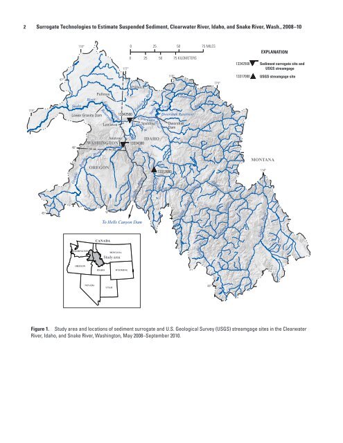
2 Surrogate Technologies to Estimate Suspended Sediment, Clearwater River, Idaho, and Snake River, Wash., 2008–10 118° 117° 0 25 50 75 MILES 0 25 50 75 KILOMETERS 13342500 EXPLANATION Sediment surrogate site and <strong>USGS</strong> streamgage 47° Potlatch 116° 115° 13317000 <strong>USGS</strong> streamgage site 119° Snake River Lower Granite Dam Pullman Lower Granite Reservoir Lewiston 13342500 Potlatch Lapwai Clearwater Lapwai R River Spalding North Fork River Dworshak Reservoir Dworshak Dam Clearwater River 46° Grande Ronde River OREGON Anatone WASHINGTON 13334300 Snake River IDAHO Salmon 13317000 River Salmon River MONTANA 114° 45° To Hells Canyon Dam South Fork River Salmon Salmon River CANADA Fork WASHINGTON MONTANA Study area Middle OREGON IDAHO WYOMING NEVADA UTAH 44° Figure 1. Study area and locations of sediment surrogate and U.S. Geological Survey (<strong>USGS</strong>) streamgage sites in the Clearwater River, Idaho, and Snake River, Washington, May 2008–September 2010. tac13-0799_fig 01
Introduction 3 The Lower Granite Lock and Dam forms the farthest upstream reservoir on the lower Snake River and captures sediment from about 27,000 mi 2 of forested and agricultural land in the Clearwater, Salmon, and Grande Ronde River basins (Teasdale, 2010). Levees were constructed along the Snake and Clearwater Rivers in Lewiston, Idaho, to contain the backwater of Lower Granite Dam and provide flood damage reduction up to the level of the Standard Project Flood, which is the streamflow expected to result from the most severe hydrologic and meteorological conditions that is characteristic of the drainage basins (U.S. Army Corps of Engineers, 2002). Sediment deposition has reduced the hydraulic capacity of the levees since completion of the dam in 1974. Periodic dredging has been performed by the USACE to maintain the navigation channel and recover hydraulic capacity of the levee system. An Environmental Impact Statement (EIS) for proposed dredging action prepared by the USACE in 2002 was suspended in litigation and the USACE is now revising the EIS as part of the development of a comprehensive Programmatic Sediment Management Plan (PSMP). The PSMP-EIS is evaluating alternatives to dredging, including drainage basin measures that may reduce sediment loads and the construction of structures within the reservoir to promote movement of sediment through the confluence. Accurate measurements of sediment concentration and load are necessary to plan and evaluate potential sediment management actions and to calibrate sediment yield and transport models. The <strong>USGS</strong> conducted a sediment sampling program in the Clearwater and Snake Rivers from 1972 to 1979 and developed sediment-transport curves that related streamflow to suspended and bedload sediment samples to calculate continuous records of sediment concentration and load. The results of the 1970s study are presented in Jones and Seitz (1980). One of the goals of the 2008–10 sediment sampling program was to determine whether the 1970s sedimenttransport curves are representative of current sedimenttransport conditions. A detailed discussion of comparisons between results of the 1970s and 2008–10 sampling programs is provided in Clark and others (2013). This report documents the ability and limitations of using sediment-surrogate technologies (surrogate technologies), such as acoustic backscatter, laser diffraction, and turbidity, to estimate SSC and load on continuous, 15-min intervals in the Snake and Clearwater Rivers draining to Lower Granite Reservoir. Surrogate technologies are evaluated to determine whether they provide improved estimates of SSC and load in comparison with sediment-transport curves generated using streamflow and sediment data collected during the 1970s and 2008–10 studies. Transport curves relying on streamflow as the explanatory variable may be poor estimators of SSC in these river systems, particularly during rain events, owing to “hysteresis” and varying sources of sediment (mostly from unregulated tributary inflows) that may not contribute a large percentage of the total flow but contribute a large amount of sediment. Sediment “hysteresis” means that sediment concentrations have different values at identical streamflow on the ascending and descending limbs of a hydrograph. A plot of streamflow and SSC during a storm event often appears to have a looped relation owing to hysteresis. Additional sediment samples and surrogate data were collected in water year 2011 to validate the acoustic backscatter surrogate models described in this report; validation results are presented in Clark and others (2013). Clark and others (2013) also presents a comparison of suspended sediment-load estimates generated using the acoustic backscatter surrogate models described in this report and using a LOADEST (LOAD ESTimation) model, which is a FORTRAN (FORmula TRANslation) program for estimating constituent loads in streams and rivers based on streamflow and time variables (Runkel and others, 2004). Background The <strong>USGS</strong> has traditionally used streamflow as a surrogate to estimate instantaneous SSC and sediment loads based on guidelines in Porterfield (1972), Glysson (1987), and Nolan and others (2005). A relation is developed between streamflow and SSC or sediment load using log transformations on both variables or plotting on logarithmic scales. The relation, which may be linear or non-linear, is called a sediment-transport curve. Uncertainties in sediment-transport curves have led to the development and evaluation of more direct, in-situ surrogate techniques. Acoustic instruments have shown great promise as sediment- surrogate technologies. They are tolerant of biological fouling and measure profiles across a sampling volume rather than at a single point in the stream (Gartner and Gray, 2005). Acoustic backscatter has been used with success as a surrogate technology for SSC or suspended solids concentration in the San Francisco Bay (Gartner, 2004), Florida estuaries (Patino and Byrne, 2004), Colorado River (Topping and others, 2004, 2006), Hudson River (Wall and others, 2006), the Aegean Region in Turkey (Elci and others, 2009), and subtropical estuaries in Australia (Chanson and others, 2008). Although the primary purpose of these types of acoustic instruments is to measure water velocity, additional measures are useful to monitor suspended-sediment transport. As the instrument emits an acoustic pulse into the water and measures the Doppler-shifted frequency of the pulse as it bounces off acoustic reflectors (typically assumed to be primarily sediment particles), the strength of the returned pulse (backscatter) also is measured as it returns to the instrument along the beam path (SonTek/Yellow Springs Instruments, 2007). Backscatter should increase when more particles are present in the water. As a result, the backscatter measurement may be related to SSC.