Geology and mineralisation of the Mewet Vein, Jelai Gold Project ...
Geology and mineralisation of the Mewet Vein, Jelai Gold Project ...
Geology and mineralisation of the Mewet Vein, Jelai Gold Project ...

You also want an ePaper? Increase the reach of your titles
YUMPU automatically turns print PDFs into web optimized ePapers that Google loves.
PT GMT Indonesia<br />
<strong>Mewet</strong> <strong>Vein</strong> : <strong>Jelai</strong> <strong>Gold</strong> <strong>Project</strong><br />
3<br />
3.1<br />
PROPERTY DESCRIPTION<br />
Location<br />
The <strong>Jelai</strong> <strong>Gold</strong> <strong>Project</strong> is located 1,550 kilometres nor<strong>the</strong>ast <strong>of</strong> Jakarta, <strong>the</strong> capital city <strong>of</strong><br />
Indonesia, close to <strong>the</strong> east coast <strong>of</strong> <strong>the</strong> Province <strong>of</strong> East Kalimantan (refer to Figure 1). The<br />
major towns in <strong>the</strong> area include Balikpapan, approximately 500 kilometres south <strong>of</strong> <strong>the</strong> project<br />
area <strong>and</strong> Tarakan 45 kilometres east <strong>of</strong> <strong>the</strong> project.<br />
The centre <strong>of</strong> <strong>the</strong> <strong>Jelai</strong> <strong>Gold</strong> <strong>Project</strong> is located at approximately E 117° 00’ 00” <strong>and</strong> N 03° 10’ 00”<br />
<strong>and</strong> <strong>the</strong> centre <strong>of</strong> <strong>the</strong> project lies approximately 410 kilometres north <strong>of</strong> Samarinda, <strong>the</strong><br />
provincial capital <strong>of</strong> East Kalimantan.<br />
3.2<br />
Tenure<br />
The concession area is held by JCM, which is beneficially controlled by KGC through a system<br />
<strong>of</strong> agreements with <strong>the</strong> Indonesian-owned company JCM, as a kuasa pertambangan (or KP,<br />
literally translated as a “mining licence”). The KP system in Indonesia is a mining rights system<br />
issued by <strong>the</strong> Kabupaten (Regency) <strong>and</strong> is a smaller, wholly locally owned mining concession<br />
system that is valid through several periods <strong>of</strong> activities from general surveys till production.<br />
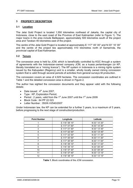
The concession covers an area <strong>of</strong> 4,929 hectares. The concession coordinates are outlined in<br />
Table 1 <strong>and</strong> <strong>the</strong> detailed concession area is shown in Figure 2.<br />
The author has sighted <strong>the</strong> concession documents <strong>and</strong> <strong>the</strong>y appear valid with <strong>the</strong> following<br />
details:<br />
• Date issued : 4 th June 2007,<br />
• Type : KP, Exploration Period,<br />
• Period : 2 years, valid from <strong>the</strong> 1 st June 2007 until <strong>the</strong> 1 st June 2009<br />
• Block Code : 64 PP 22 023<br />
• Letter Number : 350/K-VI/540/2007<br />
Under Indonesian law, <strong>the</strong> KP can be extended for a fur<strong>the</strong>r 3 years, to a maximum <strong>of</strong> 5 years,<br />
before progressing to <strong>the</strong> next stage <strong>of</strong> construction/production.<br />
Point Number Longitude Latitude<br />
1 E 116° 58' 15" N 03° 14' 30"<br />
2 E 117° 01' 00" N 03° 14' 30"<br />
3 E 117° 01' 00" N 03° 13' 45"<br />
4 E 117° 02' 00" N 03° 13' 45"<br />
5 E 117° 02' 00" N 03° 11' 30"<br />
6 E 117° 00' 00" N 03° 11' 30"<br />
7 E 117° 00' 00" N 03° 11' 00"<br />
8 E 116° 59' 15" N 03° 11' 00"<br />
9 E 116° 59' 15" N 03° 09' 45"<br />
10 E 116° 57' 45" N 03° 09' 45"<br />
11 E 116° 57' 45" N 03° 13' 15"<br />
12 E 116° 58' 15" N 03° 13' 15"<br />
Table 1. Block coordinates <strong>of</strong> <strong>the</strong> JCM concession.<br />
0065 JCM/GEO/2009.04 Page 10