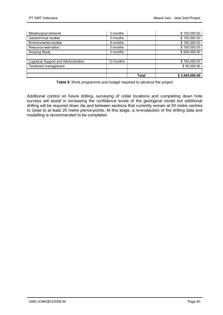
PT GMT Indonesia <strong>Mewet</strong> <strong>Vein</strong> : <strong>Jelai</strong> <strong>Gold</strong> <strong>Project</strong> Metallurgical testwork 3 months $ 100,000.00 Geotechnical studies 3 months $ 150,000.00 Environmental studies 9 months $ 150,000.00 Resource estimation 3 months $ 100,000.00 Scoping Study 3 months $ 500,000.00 Logistical Support <strong>and</strong> Administration 12 months $ 750,000.00 Tenement management $ 50,000.00 Total $ 3,445,000.00 Table 9. Work programme <strong>and</strong> budget required to advance <strong>the</strong> project Additional control on future drilling, surveying <strong>of</strong> collar locations <strong>and</strong> completing down hole surveys will assist in increasing <strong>the</strong> confidence levels <strong>of</strong> <strong>the</strong> geological model but additional drilling will be required down dip <strong>and</strong> between sections that currently remain at 50 metre centres to close to at least 25 metre pierce-points. At this stage, a re-evalaution <strong>of</strong> <strong>the</strong> drilling data <strong>and</strong> modelling is recommended to be completed. 0065 JCM/GEO/2009.04 Page 40
PT GMT Indonesia <strong>Mewet</strong> <strong>Vein</strong> : <strong>Jelai</strong> <strong>Gold</strong> <strong>Project</strong> 14 14.1 REFERENCES Text References BRGM 1982. Geological mapping <strong>and</strong> mineral exploration in North-east Kalimantan 1979-1982. Final Report. Report Bureau de Recherches Geologiques et Minieres, Orleans, France No. 82 RDM 007 A), October 1982. (BRGM authors: Lefevre, J C, Collart, J, Joubert, M, Nagel, J L, & Paupy A.) Buchanan, L.S., 1981. Precious metal deposits associated with volcanic environments in <strong>the</strong> Southwest. Arizona Geol. Soc. Digest, v 14, p 237-261. Fleming, G., 1993. Borneo <strong>Project</strong>, selective reconnaissance survey, Unpubl. Co. Rept. (PT Macan Mas Minerindo). Hall, R 1996. Reconstructing Cainozoic SE Asia. In: Hall, R <strong>and</strong> Blundell, D J (eds) Tectonic evolution <strong>of</strong> SE Asia. Geological Society Special Publication No. 106, 153-184. Katili, J.A., 1973. On Fitting Certain Geological <strong>and</strong> Geophysical Features <strong>of</strong> <strong>the</strong> Indonesian Isl<strong>and</strong> Arc to <strong>the</strong> New Global Tectonics. In: P.J. Coleman (ed), The Western Pacific Isl<strong>and</strong> Arcs, Marginal Seas, Geochemistry, Univ. Western Australia Press, 287-305. Kirwin, D.J.., 1993. Technical notes concerning <strong>the</strong> epi<strong>the</strong>rmal gold-silver potential <strong>of</strong> Nor<strong>the</strong>ast Kalimantan, Indonesia. (Unpub internal company report). Kirwin, D.J., & Sennitt, C.M., 1994. Aerial reconnaissance conducted in nor<strong>the</strong>ast Kalimantan, Indonesia. (Unpub internal company report). Le Bel, L, Nagel, J.L, Lecomte, P, Machali Muchsin A. 1985. CTA39A, Follow-up work in <strong>the</strong> Longlaai area, NE Kalimantan (The Longlaai <strong>Project</strong>), Phase 1 (1984-1985), BRGM Report 86 IDN 001, 107pp. Morrison, G., Dong, G., <strong>and</strong> Jaireth, S., 1991. Textural zoning in epi<strong>the</strong>rmal quartz veins. Klondike Exploration Services, Townsville, Australia. Nagel, J L 1987. Drilling in <strong>the</strong> nor<strong>the</strong>rn part <strong>of</strong> <strong>the</strong> Long Laai skarns. BRGM-Anekatambang, J.V.- 1987, BRGM Report 87 IDN 224, 25p. Nagel, J L 1990. CTA 39A. Exploration <strong>of</strong> <strong>the</strong> Long Laai Zn-Pb-Ag skarn <strong>mineralisation</strong> in <strong>the</strong> Tahling Basin, Kalimantan - Timur (Indonesia). BRGM Report, R-30433, DEX-DAM-90. Pieters, P E, Trail, D S <strong>and</strong> Supriatna, S 1987. Correlation <strong>of</strong> early Tertiary rocks across Kalimantan.Proceedings Indonesia Petroleum Association Association 16th Annual Convention, October 1987, 291- 306. Pieters, P E <strong>and</strong> Supriatna, S 1990. Geological map <strong>of</strong> <strong>the</strong> West, Central <strong>and</strong> East Kalimantan Area, Scale 1 : 1,000,000. Geological Research <strong>and</strong> Development Centre, B<strong>and</strong>ung, Indonesia. Pieters, P E, Surono <strong>and</strong> Noya, Y 1993a. <strong>Geology</strong> <strong>of</strong> <strong>the</strong> Puttissibau sheet area, Kalimantan, 1 : 250,000. Geological Research <strong>and</strong> Development Centre, B<strong>and</strong>ung, Indonesia. Pieters, P E, Abidin, H Z <strong>and</strong> Sudana, D 1993b. <strong>Geology</strong> <strong>of</strong> <strong>the</strong> Long Pahangai sheet area, Kalimantan, 1 : 250,000, Geological Research <strong>and</strong> Development Centre, B<strong>and</strong>ung, Indonesia. Sennitt, C.M. <strong>and</strong> Kirwin D.J. (1994). Geological Assessment <strong>and</strong> Evaluation <strong>of</strong> The <strong>Jelai</strong> River Kelapis <strong>and</strong> Long Laai Areas, Nor<strong>the</strong>ast Kalimantan, Indonesia (Internal Company Report). Setiawan, B. 1993. Les lignees granitiques et les skarns mineralises en Zn de Longlaai, Estalimantan (Borneo, Indonesie). Document du BRGM No 227. 0065 JCM/GEO/2009.04 Page 41