Geology and mineralisation of the Mewet Vein, Jelai Gold Project ...
Geology and mineralisation of the Mewet Vein, Jelai Gold Project ...
Geology and mineralisation of the Mewet Vein, Jelai Gold Project ...
Create successful ePaper yourself
Turn your PDF publications into a flip-book with our unique Google optimized e-Paper software.
PT GMT Indonesia<br />
<strong>Mewet</strong> <strong>Vein</strong> : <strong>Jelai</strong> <strong>Gold</strong> <strong>Project</strong><br />
mapping, rock chip sampling, stream sediment sampling, ridge <strong>and</strong> spur soil sampling, grid<br />
based soil sampling, geophysics (limited), trenching <strong>and</strong> drilling.<br />
The program utilised a dual-engined man-portable Drill Technics DT450P contracted from P.T.<br />
Radial Drilling Indonesia, which was capable <strong>of</strong> drilling 250 metres HQ diameter diamond core,<br />
with a maximum capability <strong>of</strong> 450 metres <strong>of</strong> NQ core. Holes were precollared by <strong>the</strong> dry<br />
plugging method <strong>and</strong> diamond coring was undertaken once competent rock was encountered.<br />
Diamond core was nominally HQ, however, reduction to NQ was sometimes necessary due to<br />
poor ground conditions or machinery problems. Down hole surveys were undertaken at 50<br />
metre intervals using an Austmine single shot camera. Orientating <strong>of</strong> <strong>the</strong> drill core was<br />
undertaken using <strong>the</strong> ‘spear <strong>and</strong> pencil’ method. Orientations were attempted on regular<br />
intervals, before <strong>the</strong> inferred vein interception depth <strong>and</strong> after intercepting <strong>the</strong> vein. Orientation<br />
readings were generally unsuccessful within <strong>the</strong> high grade epi<strong>the</strong>rmal veins due to <strong>the</strong>ir<br />
fractured or brecciated nature. Drilling was carried out on a 2x12 hour shift per day basis.<br />
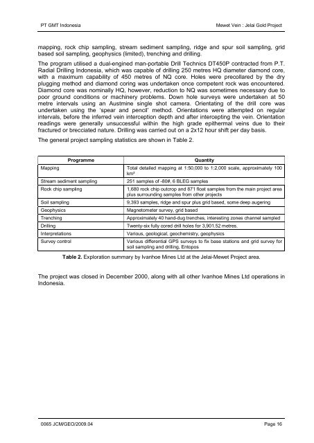
The general project sampling statistics are shown in Table 2.<br />
Programme<br />
Quantity<br />
Mapping Total detailed mapping at 1:50,000 to 1:2,000 scale, approximately 100<br />
km²<br />
Stream sediment sampling<br />
251 samples <strong>of</strong> -80#, 6 BLEG samples<br />
Rock chip sampling<br />
1,680 rock chip outcrop <strong>and</strong> 871 float samples from <strong>the</strong> main project area<br />
plus surrounding samples from o<strong>the</strong>r projects<br />
Soil sampling<br />
9,393 samples, ridge <strong>and</strong> spur plus grid based, some deep augering<br />
Geophysics<br />
Magnetometer survey, grid based<br />
Trenching<br />
Approximately 40 h<strong>and</strong>-dug trenches, interesting zones channel sampled<br />
Drilling<br />
Twenty-six fully cored drill holes for 3,901.52 metres.<br />
Interpretations<br />
Various, geological, geochemistry, geophysics<br />
Survey control<br />
Various differential GPS surveys to fix base stations <strong>and</strong> grid survey for<br />
soil sampling <strong>and</strong> drilling, Entopos<br />
Table 2. Exploration summary by Ivanhoe Mines Ltd at <strong>the</strong> <strong>Jelai</strong>-<strong>Mewet</strong> <strong>Project</strong> area.<br />
The project was closed in December 2000, along with all o<strong>the</strong>r Ivanhoe Mines Ltd operations in<br />
Indonesia.<br />
0065 JCM/GEO/2009.04 Page 16


