BALTICA17 - KlaipÄdos universitetas
BALTICA17 - KlaipÄdos universitetas
BALTICA17 - KlaipÄdos universitetas

You also want an ePaper? Increase the reach of your titles
YUMPU automatically turns print PDFs into web optimized ePapers that Google loves.
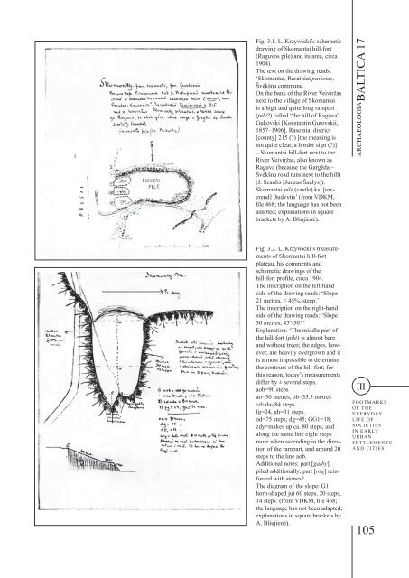
Fig. 3.1. L. Krzywicki’s schematic<br />
drawing of Skomantai hill-fort<br />
(Raguvos pile) and its area, circa<br />
1904).<br />
The text on the drawing reads:<br />
‘Skomantai, Raseiniai pavietas,<br />
Švėkšna commune.<br />
On the bank of the River Veiviržas<br />
next to the village of Skomantai<br />
is a high and quite long rampart<br />
(pile?) called “the hill of Raguva”.<br />
Gukovski [Konstantin Gutovskii,<br />
1857–1906], Raseiniai district<br />
[county] 215 (?) [the meaning is<br />
not quite clear, a border sign (?)]<br />
– Skomantai hill-fort next to the<br />
River Veiviržas, also known as<br />
Raguva (because the Gargždai–<br />
Švėkšna road runs next to the hill)<br />
(J. Szaulis [Juozas Šaulys]).<br />
Skomantai pilė (castle) ks. [reverend]<br />
Budvytis’ (from VDKM,<br />
file 468; the language has not been<br />
adapted; explanations in square<br />
brackets by A. Bliujienė).<br />
ARCHAEOLOGIA BALTICA 17<br />
Fig. 3.2. L. Krzywicki’s measurements<br />
of Skomantai hill-fort<br />
plateau, his comments and<br />
schematic drawings of the<br />
hill-fort profile, circa 1904.<br />
The inscription on the left-hand<br />
side of the drawing reads: ‘Slope<br />
21 metres, ≤ 45%, steep.’<br />
The inscription on the right-hand<br />
side of the drawing reads: ‘Slope<br />
30 metres, 45º-50º.’<br />
Explanation: ‘The middle part of<br />
the hill-fort (pilė) is almost bare<br />
and without trees; the edges, however,<br />
are heavily overgrown and it<br />
is almost impossible to determine<br />
the contours of the hill-fort; for<br />
this reason, today’s measurements<br />
differ by ± several steps.<br />
aob=90 steps<br />
ao=30 metres, ob=33.5 metres<br />
cd+da=84 steps<br />
fg=24, gh=31 steps.<br />
od=75 steps; dg=45; GG1=18;<br />
cdy=makes up ca. 80 steps, and<br />
along the same line eight steps<br />
more when ascending in the direction<br />
of the rampart, and around 20<br />
steps to the line aob.<br />
Additional notes: part [galby]<br />
piled additionally; part [rog] reinforced<br />
with stones?<br />
The diagram of the slope: G1<br />
horn-shaped jut 60 steps, 20 steps,<br />
14 steps’ (from VDKM, file 468;<br />
the language has not been adapted;<br />
explanations in square brackets by<br />
A. Bliujienė).<br />
III<br />
FOOTMARKS<br />
OF THE<br />
EVERYDAY<br />
LIFE OF<br />
SOCIETIES<br />
IN EARLY<br />
URBAN<br />
SETTLEMENTS<br />
AND CITIES<br />
105