BALTICA17 - KlaipÄdos universitetas
BALTICA17 - KlaipÄdos universitetas
BALTICA17 - KlaipÄdos universitetas

You also want an ePaper? Increase the reach of your titles
YUMPU automatically turns print PDFs into web optimized ePapers that Google loves.
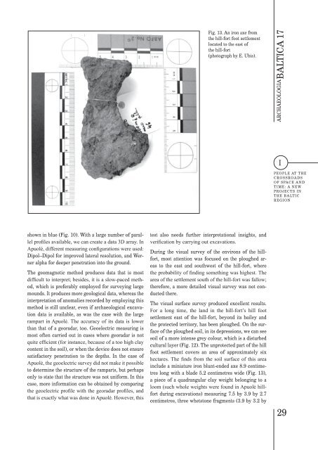
Fig. 13. An iron axe from<br />
the hill-fort foot settlement<br />
located to the east of<br />
the hill-fort<br />
(photograph by E. Ubis).<br />
ARCHAEOLOGIA BALTICA 17<br />
I<br />
PEOPLE AT THE<br />
CROSSROADS<br />
OF SPACE AND<br />
TIME: A NEW<br />
PROJECTS IN<br />
THE BALTIC<br />
REGION<br />
shown in blue (Fig. 10). With a large number of parallel<br />
profiles available, we can create a data 3D array. In<br />
Apuolė, different measuring configurations were used:<br />
Dipol–Dipol for improved lateral resolution, and Werner<br />
alpha for deeper penetration into the ground.<br />
The geomagnetic method produces data that is most<br />
difficult to interpret; besides, it is a slow-paced method,<br />
which is preferably employed for surveying large<br />
mounds. It produces more geological data, whereas the<br />
interpretation of anomalies recorded by employing this<br />
method is still unclear, even if archaeological excavation<br />
data is available, as was the case with the large<br />
rampart in Apuolė. The accuracy of its data is lower<br />
than that of a georadar, too. Geoelectric measuring is<br />
most often carried out in cases where georadar is not<br />
quite efficient (for instance, because of a too high clay<br />
content in the soil), or when the device does not ensure<br />
satisfactory penetration to the depths. In the case of<br />
Apuolė, the geoelectric survey did not make it possible<br />
to determine the structure of the ramparts, but perhaps<br />
only to state that the structure was not uniform. In this<br />
case, more information can be obtained by comparing<br />
the geoelectric profile with the georadar profiles, and<br />
that is exactly what was done in Apuolė. However, this<br />
test also needs further interpretational insights, and<br />
verification by carrying out excavations.<br />
During the visual survey of the environs of the hillfort,<br />
most attention was focused on the ploughed areas<br />
to the east and southwest of the hill-fort, where<br />
the probability of finding something was highest. The<br />
area of the settlement south of the hill-fort was fallow;<br />
therefore, a more detailed visual survey was not conducted<br />
there.<br />
The visual surface survey produced excellent results.<br />
For a long time, the land in the hill-fort’s hill foot<br />
settlement east of the hill-fort, beyond its bailey and<br />
the protected territory, has been ploughed. On the surface<br />
of the ploughed soil, in its depressions, we can see<br />
soil of a more intense grey colour, which is a disturbed<br />
cultural layer (Fig. 12). The unprotected part of the hill<br />
foot settlement covers an area of approximately six<br />
hectares. The finds from the soil surface of this area<br />
include a miniature iron blunt-ended axe 8.9 centimetres<br />
long with a blade 5.2 centimetres wide (Fig. 13),<br />
a piece of a quadrangular clay weight belonging to a<br />
loom (such whole weights were found in Apuolė hillfort<br />
during excavations) measuring 7.5 by 3.9 by 2.7<br />
centimetres, three whetstone fragments (3.9 by 3.2 by<br />
29