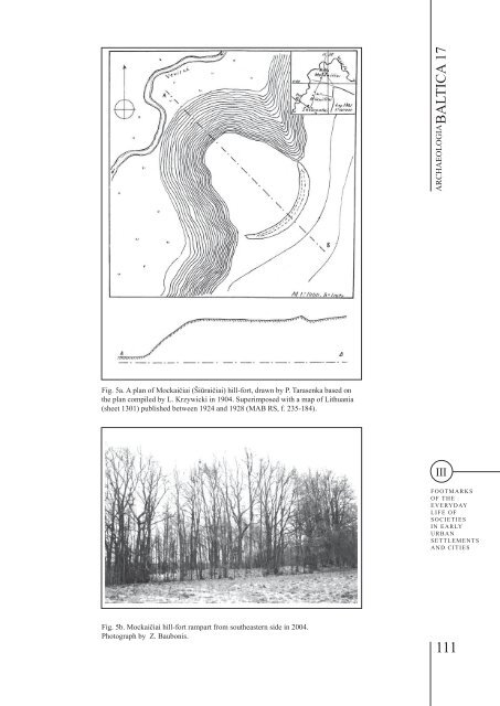
Skomantai Hill- Fort in Western Lithuania: a Case Study on Habitation Site and Environment AUDRONĖ BLIUJIENĖ, MIGLĖ STANČIKAITĖ, DALIA KISIELIENĖ JONAS MAŽEIKA, RIČARDAS TARAŠKEVIČIUS, SEBASTIAN MESSAL, PIOTR SZWARCZEWSKI, JAROSŁAW KUSIAK, RIMUTĖ STAKĖNIENĖ structures in the Lamata area. Furthermore, the hillfort is surrounded by three satellite sites, that is, burial grounds and a hill-fort situated in close proximity to Skomantai. However, the impressive exterior of the hill-fort and the complex of monuments do not match the very scarce historical and archaeological data about the site itself. Skomantai hill-fort, also known as Ragokalnis, Raguva and Papilys, stands on the right bank of the River Veiviržas; the river’s wide valley surrounds the east and southeast flanks of the hill-fort plateau, which indeed looks like a Ragokalnis, or a ‘hornshaped hill’ (Figs. 2; 3.1; 4; Plate VII.1). 10 Just like any other hill-fort, Skomantai and its importance can only be comprehended within a certain context, that is, in its relationship with the surrounding monuments (settlements, burial grounds, zones of economic activity and raw materials, a local sacred place), and in the context of a micro-region that included several groups of monuments. A micro-region is understood as a unit bound by economic and administrative ties, the existence of which (the unit) can be based on statistical methods offered by the paradigm of microregions and regions (Thurston, Salisbury 2009). In the second half of the 19th century, when people became interested in the distribution and history of Skomantai and the neighbouring villages in the middle reaches of the River Veiviržas, it became obvious that ‘there was a hill-fort in every single village’ (Krzywicki 1906, p.57). In other words, there is an exceptionally high concentration of hill-forts and other monuments. There are six hill-forts and six burial grounds known on the banks of the River Veiviržas; there is also a sacred site in the forest close to Šiupariai hill-fort (Plate VII.1). The monuments in the region are not only arranged in compact groups a certain distance from each other, but they are also situated exclusively on the banks of the rivers Veiviržas, Šalpė and Ašva. Meanwhile, in the area surrounded by river bends and further from the banks, there are no known archaeological monuments, nor have individual finds been found there. Two assumptions can be made regarding the distribution of 10 During his excavations in Skomantai hill-fort in 1903 or 1904, Krzywicki measured the hill-fort and drew several schematic plans of it and its environs with explanations (VDKM, b. b. 468 and 469). At the same time, he visited the hill-fort of Mockaičiai (Šiūraičiai), and apparently also measured and described this hill-fort. When preparing his work ‘Archaeological Material of Lithuania’, P. Tarasenka (1892–1962) redrew these plans and added, for the sake of guidance, details from the map of Lithuania (the publication of which began in 1924) relating to the neighbouring locations (Figs. 4; 5) (MAB, f. 235-287; 235- 184). Regrettably, Krzywicki never published the results of his excavations, and the material prepared by Tarasenka was not used in the published atlas of monuments. the monuments. They are distributed in this way because of the natural conditions: the wet 11 and wooded Samogitian moraine lowland (even today, there is the large marshy Šiūraičiai forest, as well as the Bilvietis forest) 12 is hardly suitable for crops or pasture. However, the dense habitation of the micro-region, palynological analysis and research into the environment suggest that since time immemorial people have found a livelihood here, that is, in the tilled fields and meadows. The micro-region surrounded (and in a way protected) by the rivers might extend for approximately eight kilometres in an east-west direction, and nine kilometres in a north-south direction. Consequently, its estimated area might be approximately 72 square kilometres. According to this theoretical model developed on micro-regions, the maximum extent of the area might cover no more than a six to ten-kilometre radius from the centre; the maximum extent of the area might cover from 100 to 300 square kilometres. The minimum extent of a micro-region in an agrarian society theoretically depended on the soil and the farming methods: these issues predetermined whether the inhabitants were able to administer the formal microregion (Kuncevičius et al. 2011, p.14ff). Although the Lamata area cannot be defined precisely, based on the distribution of monuments, the total area of the land might be estimated at 100 to 500 square kilometres, in which a total of six micro-regions of varying sizes can be identified. These micro-regions correspond to the castle districts (Borchukunge) known from written sources (Žulkus 1989, p.21ff; 2004, pp.44-45). Theoretically, in the Skomantai micro-region, every hill-fort and its settlement would have been in possession of around nine to 10.5 square kilometres of land intended for economic activity (ploughed fields, meadows, forest, swamps). 13 However, as research into other west Lithuanian monuments from the first millennium indicates, fords across rivers next to monuments transfer their economic activities to the other bank of the river, and thus the land area used for economic activity increases. 11 For this, see the chapter ‘Palynological investigations’. 12 There are more than ten tributaries of the rivers Veiviržas, Šalpė and Ašva in the micro-region. These include the Sveisna/Švėkšnalė, mentioned in the Order’s road descriptions dating from 1384. In 1387, this river was mentioned as Swexte. Consequently, the Švėkšnalė/ Švėkšta (a right tributary of the River Ašva), the Veiviržas and other rivers of west Lithuania are mentioned in the Order’s road descriptions. 13 This estimation is close to the theoretical model whereby one habitation in the Lamata area should have had in its possession on average 12 to 19 square kilometres (Žulkus 1989, p.23; 2004, p.45). 110
ARCHAEOLOGIA BALTICA 17 Fig. 5a. A plan of Mockaičiai (Šiūraičiai) hill-fort, drawn by P. Tarasenka based on the plan compiled by L. Krzywicki in 1904. Superimposed with a map of Lithuania (sheet 1301) published between 1924 and 1928 (MAB RS, f. 235-184). III FOOTMARKS OF THE EVERYDAY LIFE OF SOCIETIES IN EARLY URBAN SETTLEMENTS AND CITIES Fig. 5b. Mockaičiai hill-fort rampart from southeastern side in 2004. Photograph by Z. Baubonis. 111
- Page 1 and 2:
ARCHAEOLOGIA BALTICA17 PEOPLE AT TH
- Page 3 and 4:
KLAIPĖDA UNIVERSITY PEOPLE AT THE
- Page 5 and 6:
CONTENTS Preface 7 I. PEOPLE AT THE
- Page 7 and 8:
PREFACE The existence of mankind is
- Page 9 and 10:
Conference moments. Polish colleagu
- Page 11 and 12:
ARCHAEOLOGIA BALTICA 17 In the terr
- Page 13:
ARCHAEOLOGIA BALTICA 17 Participant
- Page 16 and 17:
Continuity of Research and Research
- Page 18 and 19:
Continuity of Research and Research
- Page 20 and 21:
Continuity of Research and Research
- Page 22 and 23:
The International Archaeologists’
- Page 24 and 25:
The International Archaeologists’
- Page 26 and 27:
The International Archaeologists’
- Page 28 and 29:
The International Archaeologists’
- Page 30 and 31:
The International Archaeologists’
- Page 32 and 33:
The International Archaeologists’
- Page 34 and 35:
The Grobiņa Complex of Dwelling Lo
- Page 36 and 37:
INGRIDA LIGA VIRSE, RITVARS RITUMS
- Page 38 and 39:
The Grobiņa Complex of Dwelling Lo
- Page 40 and 41:
The Grobiņa Complex of Dwelling Lo
- Page 42:
The Grobiņa Complex of Dwelling Lo
- Page 46 and 47:
The Significance of Deposits of Nat
- Page 48 and 49:
MIRJA OTS The Significance of Depos
- Page 50 and 51:
MIRJA OTS The Significance of Depos
- Page 52 and 53:
The Significance of Deposits of Nat
- Page 54 and 55:
The Significance of Deposits of Nat
- Page 56 and 57:
The Significance of Deposits of Nat
- Page 58 and 59:
The Significance of Deposits of Nat
- Page 60 and 61: Trade, Salt And Amber. The Formatio
- Page 62 and 63: BARTOSZ KONTNY Trade, Salt And Ambe
- Page 64 and 65: Trade, Salt And Amber. The Formatio
- Page 66 and 67: BARTOSZ KONTNY Trade, Salt And Ambe
- Page 68 and 69: Trade, Salt And Amber. The Formatio
- Page 70 and 71: BARTOSZ KONTNY Trade, Salt And Ambe
- Page 72 and 73: Trade, Salt And Amber. The Formatio
- Page 74 and 75: Trade, Salt And Amber. The Formatio
- Page 76: Trade, Salt And Amber. The Formatio
- Page 80 and 81: Early Slavs in the Southwest Baltic
- Page 82 and 83: SEBASTIAN MESSAL, BARTŁOMIEJ ROGAL
- Page 84 and 85: SEBASTIAN MESSAL, BARTŁOMIEJ ROGAL
- Page 86 and 87: SEBASTIAN MESSAL, BARTŁOMIEJ ROGAL
- Page 88 and 89: Early Slavs in the Southwest Baltic
- Page 90 and 91: Early Slavs in the Southwest Baltic
- Page 92 and 93: NIKOLAI A. KRENKE The Moskva River
- Page 94 and 95: NIKOLAI A. KRENKE The Moskva River
- Page 96 and 97: NIKOLAI A. KRENKE The Moskva River
- Page 98 and 99: NIKOLAI A. KRENKE The Moskva River
- Page 100 and 101: The Moskva River Basin in the Iron
- Page 102 and 103: Skomantai Hill- Fort in Western Lit
- Page 104 and 105: Skomantai Hill- Fort in Western Lit
- Page 106 and 107: Skomantai Hill- Fort in Western Lit
- Page 108 and 109: Skomantai Hill- Fort in Western Lit
- Page 112 and 113: AUDRONĖ BLIUJIENĖ, MIGLĖ STANČI
- Page 114 and 115: AUDRONĖ BLIUJIENĖ, MIGLĖ STANČI
- Page 116 and 117: Skomantai Hill- Fort in Western Lit
- Page 118 and 119: Skomantai Hill- Fort in Western Lit
- Page 120 and 121: Skomantai Hill- Fort in Western Lit
- Page 122 and 123: Skomantai Hill- Fort in Western Lit
- Page 124 and 125: AUDRONĖ BLIUJIENĖ, MIGLĖ STANČI
- Page 126 and 127: Skomantai Hill- Fort in Western Lit
- Page 128 and 129: Skomantai Hill- Fort in Western Lit
- Page 130 and 131: Skomantai Hill- Fort in Western Lit
- Page 132 and 133: Skomantai Hill- Fort in Western Lit
- Page 134 and 135: Skomantai Hill- Fort in Western Lit
- Page 136 and 137: Structure, Chronology and Interregi
- Page 138 and 139: ROMAS JAROCKIS Structure, Chronolog
- Page 140 and 141: ROMAS JAROCKIS Structure, Chronolog
- Page 142 and 143: ROMAS JAROCKIS Structure, Chronolog
- Page 144 and 145: ROMAS JAROCKIS Structure, Chronolog
- Page 146 and 147: Structure, Chronology and Interregi
- Page 148 and 149: ROMAS JAROCKIS Structure, Chronolog
- Page 150 and 151: Structure, Chronology and Interregi
- Page 152 and 153: Of Friends and Food: Dogs in Mediev
- Page 154 and 155: Of Friends and Food: Dogs in Mediev
- Page 156 and 157: Of Friends and Food: Dogs in Mediev
- Page 158 and 159: Renaissance Footwear as a Mark of S
- Page 160 and 161:
Renaissance Footwear as a Mark of S
- Page 162 and 163:
Renaissance Footwear as a Mark of S
- Page 164 and 165:
Renaissance Footwear as a Mark of S
- Page 166 and 167:
Renaissance Footwear as a Mark of S
- Page 168 and 169:
Renaissance Footwear as a Mark of S
- Page 170:
Renaissance Footwear as a Mark of S
- Page 174:
Klaipėdos universiteto leidykla AR
- Page 178 and 179:
Plates 1 1 2 II Plate II MIRJA OTS
- Page 180 and 181:
Plates 1 2 IV Plate IV INGRIDA LIGA
- Page 182 and 183:
Plates 1 2 4 3 VI Plate VI ARŪNAS
- Page 184:
Plates 1 2 3 VIII Plate VIII ROMAS