BALTICA17 - KlaipÄdos universitetas
BALTICA17 - KlaipÄdos universitetas
BALTICA17 - KlaipÄdos universitetas

You also want an ePaper? Increase the reach of your titles
YUMPU automatically turns print PDFs into web optimized ePapers that Google loves.
Skomantai Hill-<br />
Fort in Western<br />
Lithuania: a<br />
Case Study<br />
on Habitation<br />
Site and<br />
Environment<br />
AUDRONĖ BLIUJIENĖ,<br />
MIGLĖ STANČIKAITĖ, DALIA<br />
KISIELIENĖ JONAS MAŽEIKA,<br />
RIČARDAS TARAŠKEVIČIUS,<br />
SEBASTIAN MESSAL, PIOTR<br />
SZWARCZEWSKI, JAROSŁAW<br />
KUSIAK, RIMUTĖ STAKĖNIENĖ<br />
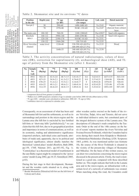
Table 2. Skomantai site and its environs 14 C dates<br />
Position Depth (cm)<br />
14<br />
C age<br />
Calibrated age Lab. code Dated material<br />
in the site<br />
(yr BP)<br />
(1σ range)<br />
Test pit 2 50 290±60 1490-1600 AD Vs-2143 Organic material,<br />
70 1970±80 50 BC-130 AD Vs-2147 charcoal from cultural<br />
layer<br />
The main core 180-182 760±30 1240-1280AD Poz-45827 Sand with organics<br />
Borehole 100-112 3990±140 2680-2290 BC Vs-2148 Sand with organics<br />
BIS-3 120-130 2190±170 410 BC-10 AD Vs-2151<br />
130-132 1560±280 130-710 AD Vs-2155<br />
River Veiviržas water level 1530±40 530-590 AD (40.8%) Vs-2135 Wood<br />
channel<br />
440-490 AD (27.5%)<br />
1640±55 340-440 AD (49.1%)<br />
480-530 AD (19.1%)<br />
Vs-2139<br />
Table 3. The activity concentrations of natural radioisotopes, values of dose<br />
rate (DR), correction for supralinearity (I), archaeological dose (AD), and TL<br />
age of pottery from the Skomantai site (after J. Kusiak)<br />
No.<br />
1<br />
2<br />
3<br />
4<br />
5<br />
Sample<br />
No.<br />
Lub<br />
4932<br />
4933<br />
4934<br />
4935<br />
4936<br />
40<br />
K<br />
(Bq/kg)<br />
502±18<br />
827±25<br />
678±25<br />
616±22<br />
512±19<br />
238<br />
U<br />
(Bq/kg)<br />
42.5±2.0<br />
54.9±2.3<br />
51.2±2.2<br />
40.1±2.1<br />
44.4±2.0<br />
232<br />
Th<br />
(Bq/kg)<br />
48.7±1.9<br />
61.2±2.2<br />
53.5±2.1<br />
48.6±2.1<br />
46.8±1.9<br />
DR<br />
(Gy/ka)<br />
3.41±0.17<br />
4.74±0.22<br />
4.14±0.17<br />
3.68±0.16<br />
3.49±0.16<br />
I<br />
(Gy)<br />
0.6<br />
0.8<br />
0<br />
0.4<br />
0.4<br />
AD<br />
(Gy)<br />
5.62±0.31<br />
5.57±0.33<br />
4.49±0.26<br />
4.92±0.29<br />
5.25±0.32<br />
TL age d<br />
(yr b2k) b<br />
1637±119<br />
1164±86<br />
1074±81<br />
1325±96<br />
1493±105<br />
TL age d<br />
(A.D. c )<br />
363±119<br />
836±86<br />
926±81<br />
675±96<br />
507±105<br />
a<br />
component derived from gamma (γ) radiation<br />
b<br />
Walker et al. (2009) proposed a notation of age in calendar years before 2000 AD (the abbreviation yr b2k)<br />
c<br />
TL age (AD) – calendar years calculated as subtraction: 2000 AD – TL age (yr b2k)<br />
d<br />
confidence interval is expressed in calendar years<br />
116<br />
Consequently, on an assessment of what has been said<br />
of Skomantai hill-fort and the settlements, as well as its<br />
surroundings and position in the micro-region and the<br />
Lamata area (the hill-fort is encircled by less fortified<br />
hill-forts or ‘short-stay hills’ [pabūtkalniai]), 18 we can<br />
claim that this hill-fort, due to its geographical position<br />
and importance in terms of communications, as well as<br />
its economic, trading and administrative significance<br />
(imported artefacts, individual coins and hoards, attributes<br />
of trade) and, apparently, due to its political and<br />
ideological significance, almost ideally matches the<br />
theoretical ‘central place’ model (Renfrew, Bath 2000,<br />
pp.159, 174ff; Näsman 2011, pp.185-192, Fig. 1).<br />
‘Central place’ as a theoretical model of resettlement in<br />
the east Baltic region might be compared to the ‘power<br />
centre’ model (Lang 2002, pp.18-25; Simniškytė 2005,<br />
p.43).<br />
During the last stage in their development, Skomantai<br />
and the wooden castle situated on it, along with<br />
18<br />
Beside Mockaičiai (Šiūraičiai) hill-fort are the hill-forts of<br />
Uoksiai and Lekiai.<br />
other wooden castles erected on the banks of the rivers<br />
Veiviržas, Šalpė, Ašva and Tenenis, did not serve<br />
as individual defensive units, but constituted parts of<br />
the integral defensive system of the Lamata area. The<br />
descriptions of Lithuania’s roads compiled by the Teutonic<br />
Order at the end of the 14th century on the basis<br />
of scouts’ reports mention the rivers Veiviržas and<br />
Sveisna/Swexte/Švėkšnalė, which the Crusaders had to<br />
cross during their march from Klaipėda to Medenicken/Medeniken/Medininkai<br />
(Dusburg §320; Scriptores<br />
1863, p.664). As was mentioned earlier (see footnote<br />
10), the source of the River Švėkšnalė is situated in<br />
the vicinity of the present-day villages of Skomantai<br />
and Mikužiai. On the basis of this written source, we<br />
can draw two conclusions concerning the micro-region<br />
discussed in the present article. Firstly, the road is mentioned<br />
as a good one, compared with those described<br />
further on. This might indicate that both in the Lamata<br />
area and in the micro-region, an infrastructure with a<br />
certain level of a network of settlements was created.<br />
When marching along this road, the Crusaders could