BALTICA17 - KlaipÄdos universitetas
BALTICA17 - KlaipÄdos universitetas
BALTICA17 - KlaipÄdos universitetas

You also want an ePaper? Increase the reach of your titles
YUMPU automatically turns print PDFs into web optimized ePapers that Google loves.
AUDRONĖ BLIUJIENĖ,<br />
MIGLĖ STANČIKAITĖ, DALIA<br />
KISIELIENĖ JONAS MAŽEIKA,<br />
RIČARDAS TARAŠKEVIČIUS,<br />
SEBASTIAN MESSAL, PIOTR<br />
SZWARCZEWSKI, JAROSŁAW<br />
KUSIAK, RIMUTĖ STAKĖNIENĖ<br />
Skomantai Hill-<br />
Fort in Western<br />
Lithuania: a<br />
Case Study<br />
on Habitation<br />
Site and<br />
Environment<br />
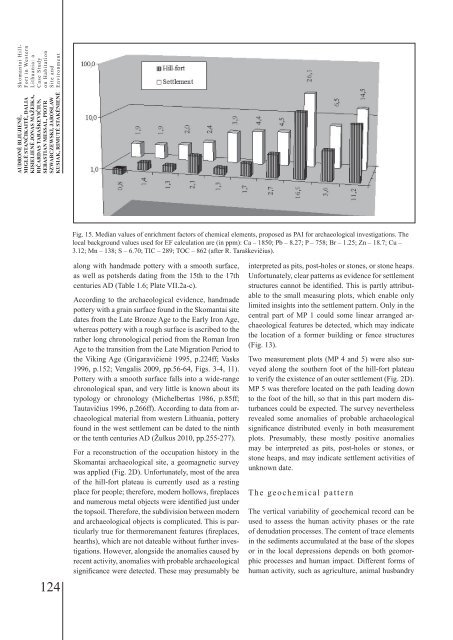
Fig. 15. Median values of enrichment factors of chemical elements, proposed as PAI for archaeological investigations. The<br />
local background values used for EF calculation are (in ppm): Ca – 1850; Pb – 8.27; P – 758; Br – 1.25; Zn – 18.7; Cu –<br />
3.12; Mn – 138; S – 6.70; TIC – 289; TOC – 862 (after R. Taraškevičius).<br />
124<br />
along with handmade pottery with a smooth surface,<br />
as well as potsherds dating from the 15th to the 17th<br />
centuries AD (Table 1.6; Plate VII.2a-c).<br />
According to the archaeological evidence, handmade<br />
pottery with a grain surface found in the Skomantai site<br />
dates from the Late Bronze Age to the Early Iron Age,<br />
whereas pottery with a rough surface is ascribed to the<br />
rather long chronological period from the Roman Iron<br />
Age to the transition from the Late Migration Period to<br />
the Viking Age (Grigaravičienė 1995, p.224ff; Vasks<br />
1996, p.152; Vengalis 2009, pp.56-64, Figs. 3-4, 11).<br />
Pottery with a smooth surface falls into a wide-range<br />
chronological span, and very little is known about its<br />
typology or chronology (Michelbertas 1986, p.85ff;<br />
Tautavičius 1996, p.266ff). According to data from archaeological<br />
material from western Lithuania, pottery<br />
found in the west settlement can be dated to the ninth<br />
or the tenth centuries AD (Žulkus 2010, pp.255-277).<br />
For a reconstruction of the occupation history in the<br />
Skomantai archaeological site, a geomagnetic survey<br />
was applied (Fig. 2D). Unfortunately, most of the area<br />
of the hill-fort plateau is currently used as a resting<br />
place for people; therefore, modern hollows, fireplaces<br />
and numerous metal objects were identified just under<br />
the topsoil. Therefore, the subdivision between modern<br />
and archaeological objects is complicated. This is particularly<br />
true for thermoremanent features (fireplaces,<br />
hearths), which are not dateable without further investigations.<br />
However, alongside the anomalies caused by<br />
recent activity, anomalies with probable archaeological<br />
significance were detected. These may presumably be<br />
interpreted as pits, post-holes or stones, or stone heaps.<br />
Unfortunately, clear patterns as evidence for settlement<br />
structures cannot be identified. This is partly attributable<br />
to the small measuring plots, which enable only<br />
limited insights into the settlement pattern. Only in the<br />
central part of MP 1 could some linear arranged archaeological<br />
features be detected, which may indicate<br />
the location of a former building or fence structures<br />
(Fig. 13).<br />
Two measurement plots (MP 4 and 5) were also surveyed<br />
along the southern foot of the hill-fort plateau<br />
to verify the existence of an outer settlement (Fig. 2D).<br />
MP 5 was therefore located on the path leading down<br />
to the foot of the hill, so that in this part modern disturbances<br />
could be expected. The survey nevertheless<br />
revealed some anomalies of probable archaeological<br />
significance distributed evenly in both measurement<br />
plots. Presumably, these mostly positive anomalies<br />
may be interpreted as pits, post-holes or stones, or<br />
stone heaps, and may indicate settlement activities of<br />
unknown date.<br />
The geochemical pattern<br />
The vertical variability of geochemical record can be<br />
used to assess the human activity phases or the rate<br />
of denudation processes. The content of trace elements<br />
in the sediments accumulated at the base of the slopes<br />
or in the local depressions depends on both geomorphic<br />
processes and human impact. Different forms of<br />
human activity, such as agriculture, animal husbandry