BALTICA17 - KlaipÄdos universitetas
BALTICA17 - KlaipÄdos universitetas
BALTICA17 - KlaipÄdos universitetas

You also want an ePaper? Increase the reach of your titles
YUMPU automatically turns print PDFs into web optimized ePapers that Google loves.
ROMAS<br />
JAROCKIS<br />
Structure, Chronology and<br />
Interregional Relations: an Analysis<br />
of the Archaeological Material<br />
from Opstainis, Vilkyškiai Iron Age<br />
Hill-Fort and Settlement<br />
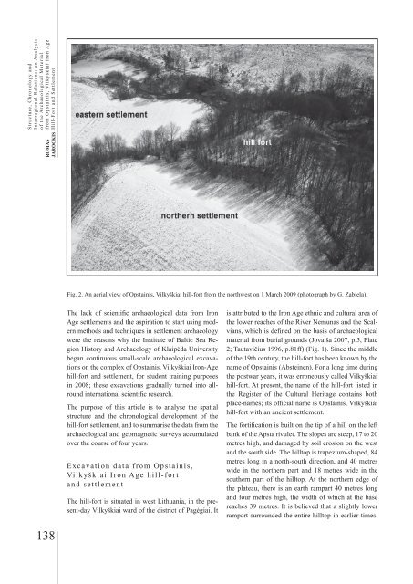
Fig. 2. An aerial view of Opstainis, Vilkyškiai hill-fort from the northwest on 1 March 2009 (photograph by G. Zabiela).<br />
The lack of scientific archaeological data from Iron<br />
Age settlements and the aspiration to start using modern<br />
methods and techniques in settlement archaeology<br />
were the reasons why the Institute of Baltic Sea Region<br />
History and Archaeology of Klaipėda University<br />
began continuous small-scale archaeological excavations<br />
on the complex of Opstainis, Vilkyškiai Iron-Age<br />
hill-fort and settlement, for student training purposes<br />
in 2008; these excavations gradually turned into allround<br />
international scientific research.<br />
The purpose of this article is to analyse the spatial<br />
structure and the chronological development of the<br />
hill-fort settlement, and to summarise the data from the<br />
archaeological and geomagnetic surveys accumulated<br />
over the course of four years.<br />
Excavation data from Opstainis,<br />
Vilkyškiai Iron Age hill-fort<br />
and settlement<br />
The hill-fort is situated in west Lithuania, in the present-day<br />
Vilkyškiai ward of the district of Pagėgiai. It<br />
is attributed to the Iron Age ethnic and cultural area of<br />
the lower reaches of the River Nemunas and the Scalvians,<br />
which is defined on the basis of archaeological<br />
material from burial grounds (Jovaiša 2007, p.5, Plate<br />
2; Tautavičius 1996, p.81ff) (Fig. 1). Since the middle<br />
of the 19th century, the hill-fort has been known by the<br />
name of Opstainis (Absteinen). For a long time during<br />
the postwar years, it was erroneously called Vilkyškiai<br />
hill-fort. At present, the name of the hill-fort listed in<br />
the Register of the Cultural Heritage contains both<br />
place-names; its official name is Opstainis, Vilkyškiai<br />
hill-fort with an ancient settlement.<br />
The fortification is built on the tip of a hill on the left<br />
bank of the Apsta rivulet. The slopes are steep, 17 to 20<br />
metres high, and damaged by soil erosion on the west<br />
and the south side. The hilltop is trapezium-shaped, 84<br />
metres long in a north-south direction, and 40 metres<br />
wide in the northern part and 18 metres wide in the<br />
southern part of the hilltop. At the northern edge of<br />
the plateau, there is an earth rampart 40 metres long<br />
and four metres high, the width of which at the base<br />
reaches 39 metres. It is believed that a slightly lower<br />
rampart surrounded the entire hilltop in earlier times.<br />
138