BALTICA17 - KlaipÄdos universitetas
BALTICA17 - KlaipÄdos universitetas
BALTICA17 - KlaipÄdos universitetas

You also want an ePaper? Increase the reach of your titles
YUMPU automatically turns print PDFs into web optimized ePapers that Google loves.
and metallurgy, influence the geochemical properties<br />
of the sediments. In most cases, an increasing concentration<br />
of particular elements (such as Cd, Pb and Zn)<br />
can be correlated with stages of human impact and<br />
with the changing environmental situation, such as<br />
the moisture regime (Fe, Mn), including a rise in the<br />
water table. This is why these proxies can be used to<br />
determine the main phases of human economic activity.<br />
The changes in selected elements in core BIS-3 are<br />
presented in Fig. 14.<br />
The deforestation of the slopes and the economic activity<br />
of the local population favoured the delivery of<br />
material to the bottom of the valley. This is illustrated<br />
in further declines in loss-on-ignition values recorded<br />
at 1.3 to 1.2 metres, 1.1 to 0.6 metres, and 0.45 to 0.3<br />
metres depth. Changes in agricultural and economic<br />
activities could be correlated with the variability of<br />
the phosphorus (P) content recorded in the sediment.<br />
Samples with a higher content of this element represent<br />
a period of extensive use of the hill-fort and the<br />
surroundings. Anthropogenic additions of phosphorus<br />
to the soil come from human refuse and waste, the<br />
products of animal husbandry in barns or pens and on<br />
livestock paths, or intentional enrichment from soil fertiliser<br />
(Holliday, Gartner 2007, pp.301-330). The most<br />
interesting information about humans comes from the<br />
analysis of trace elements such as Cd, Pb and Zn. An<br />
increased content of these elements in the vertical profile<br />
could be associated with economic activity during<br />
the Roman Iron Age (2.5 to 1.6 metres) and the operation<br />
of the settlement throughout Medieval times: there<br />
are two peaks, corresponding to the two phases of occupation<br />
of the site (1.5 to 0.8 metres), and the effects<br />
of economic development in the modern era (from the<br />
surface to a depth of 0.3 metres). The elevated iron and<br />
manganese content (1.7 to 0.9 metres deep) could be<br />
related to the formation of wet conditions at the base of<br />
the hill-fort (bog ore). According to the geochemical,<br />
lithological and sedimentological data collected (Figs.<br />
12; 14), conclusions could be made about the existence<br />
of a natural moat during Late Roman and Early Medieval<br />
times in the investigated area.<br />
Two main branches (Th, Hf, Sr, Ba, Rb, Ni, Fe, Y, Cr,<br />
Nb, Ti, K, Al, Mg, Si, Zr, Na, and Pb, Ca, Mn, Zn,<br />
Cu, P, Br, TIC, S, TOC) were distinguished in the dendrogram<br />
representing the samples collected within the<br />
ARCHAEOLOGIA BALTICA 17<br />
III<br />
FOOTMARKS<br />
OF THE<br />
EVERYDAY<br />
LIFE OF<br />
SOCIETIES<br />
IN EARLY<br />
URBAN<br />
SETTLEMENTS<br />
AND CITIES<br />
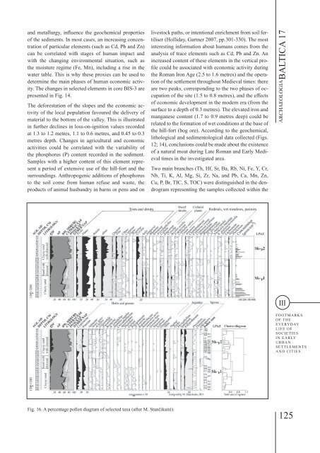
Fig. 16. A percentage pollen diagram of selected taxa (after M. Stančikaitė).<br />
125