

ON THE NEED FOR VOLUMETRIC RADAR DATA WHEN ISSUING ...
ON THE NEED FOR VOLUMETRIC RADAR DATA WHEN ISSUING ...
ON THE NEED FOR VOLUMETRIC RADAR DATA WHEN ISSUING ...

Create successful ePaper yourself
Turn your PDF publications into a flip-book with our unique Google optimized e-Paper software.
12<br />
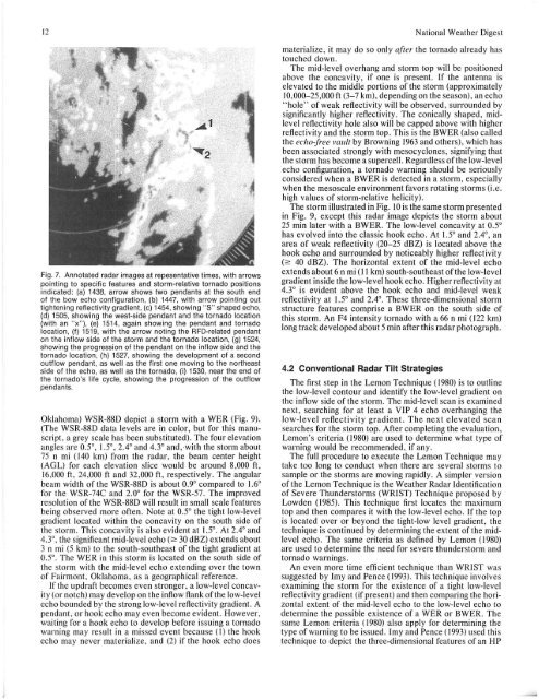
Fig. 7. Annotated radar images at repesentative times, with arrows<br />
pointing to specific features and storm-relative tornado positions<br />
indicated : (a) 1438, arrow shows two pendants at the south end<br />
of the bow echo configuration, (b) 1447, with arrow pointing out<br />
tightening reflectivity gradient, (c) 1454, showing "S" shaped echo,<br />
(d) 1505, showing the west-side pendant and the tornado location<br />
(with an " x"), (e) 1514, again showing the pendant and tornado<br />
location, (f) 1519, with the arrow noting the RFD-related pendant<br />
on the inflow side of the storm and the tornado location, (g) 1524,<br />
showing the progression of the pendant on the inflow side and the<br />
tornado location, (h) 1527, showing the development of a second<br />
outflow pendant, as well as the first one moving to the northeast<br />
side of the echo, as well as the tornado, (i) 1530, near the end of<br />
the tornado's life cycle, showing the progression of the outflow<br />
pendants.<br />
Oklahoma) WSR-88D depict a storm with a WER (Fig. 9).<br />
(The WSR-88D data levels are in color, but for this manuscript,<br />
a grey scale has been substituted). The four elevation<br />
angles are OS, IS, 2.4° and 4.3° and, with the storm about<br />
75 n mi (140 km) from the radar, the beam center height<br />
(AGL) for each elevation slice would be around 8,000 ft,<br />
16,000 ft , 24,000 ft and 32 ,000 ft , respectively. The angular<br />
beam width of the WSR-88D is about 0.9° compared to 1.6°<br />
for the WSR-74C and 2.0° for the WSR-57. The improved<br />
resolution of the WSR-88D will result in small scale features<br />
being observed more often. Note at OS the tight low-level<br />
gradient located within the concavity on the south side of<br />
the storm. This concavity is also evident at 1.5°. At 2.4° and<br />
4.3°, the significant mid-level echo (;:;: 30 dBZ) extends about<br />
3 n mi (5 km) to the south-southeast of the tight gradient at<br />
OS. The WER in this storm is located on the south side of<br />
the storm with the mid-level echo extending over the town<br />
of Fairmont, Oklahoma, as a geographical reference.<br />
If the updraft becomes even stronger, a low-level concavity<br />
(or notch) may develop on the inflow flank of the low-level<br />
echo bounded by the strong low-level reflectivity gradient. A<br />
pendant, or hook echo may even become evident. However,<br />
waiting for a hook echo to develop before issuing a tornado<br />
warning may result in a missed event because (I) the hook<br />
echo may never materialize, and (2) if the hook echo does<br />
National Weather Digest<br />
materialize, it may do so only ajier the tornado already has<br />
touched down.<br />
The mid-level overhang and storm top will be positioned<br />
above the concavity, if one is present. If the antenna is<br />
elevated to the middle portions of the storm (approximately<br />
10,000-25,000 ft (3-7 km), depending on the season), an echo<br />
"hole" of weak reflectivity will be observed, surrounded by<br />
significantly higher reflectivity. The conically shaped, midlevel<br />
reflectivity hole also will be capped above with higher<br />
reflectivity and the storm top. This is the BWER (also called<br />
the echo-free vault by Browning 1963 and others), which has<br />
been associated strongly with mesocyclones, signifying that<br />
the storm has become a supercell. Regardless of the low-level<br />
echo configuration, a tornado warning should be seriously<br />
considered when a BWER is detected in a storm, especially<br />
when the mesoscale environment favors rotating storms (i .e .<br />
high values of storm-relative helicity).<br />
The storm illustrated in Fig. 10 is the same storm presented<br />
in Fig. 9, except this radar image depicts the storm about<br />
25 min later with a BWER. The low-level concavity at OS<br />
has evolved into the classic hook echo. At IS and 2.4°, an<br />
area of weak reflectivity (20-25 dBZ) is located above the<br />
hook echo and surrounded by noticeably higher reflectivity<br />
(;:;: 40 dBZ). The horizontal extent of the mid-level echo<br />
extends about 6 n mi (II km) south-southeast of the low-level<br />
gradient inside the low-level hook echo. Higher reflectivity at<br />
4.3° is evident above the hook echo and mid-level weak<br />
reflectivity at 1.5° and 2.4°. These three-dimensional storm<br />
structure features comprise a BWER on the south side of<br />
this storm. An F4 intensity tornado with a 66 n mi (122 km)<br />
long track developed about 5 min after this radar photograph.<br />
4.2 Conventional Radar Tilt Strategies<br />
The first step in the Lemon Technique (1980) is to outline<br />
the low-level contour and identify the low-level gradient on<br />
the inflow side of the storm. The mid-level scan is examined<br />
next, searching for at least a VIP 4 echo overhanging the<br />
low-level reflectivity gradient. The next elevated sca n<br />
searches for the storm top. After completing the evaluation,<br />
Lemon's criteria (1980) are used to determine what type of<br />
warning would be recommended, if any.<br />
The full procedure to execute the Lemon Technique may<br />
take too long to conduct when there are several storms to<br />
sample or the storms are moving rapidly. A simpler version<br />
of the Lemon Technique is the Weather Radar Identification<br />
of Severe Thunderstorms (WRIST) Technique proposed by<br />
Lowden (1985). This technique first locates the maximum<br />
top and then compares it with the low-level echo. If the top<br />
is located over or beyond the tight-low level gradient, the<br />
technique is continued by determining the extent of the midlevel<br />
echo. The same criteria as defined by Lemon (1980)<br />
are used to determine the need for severe thunderstorm and<br />
tornado warnings.<br />
An even more time efficient technique than WRIST was<br />
suggested by Imy and Pence (1993) . This technique involves<br />
examining the storm for the existence of a tight low-level<br />
reflectivity gradient (if present) and then comparing the horizontal<br />
extent of the mid-level echo to the low-level echo to<br />
determine the possible existence of a WER or BWER. The<br />
same Lemon criteria (1980) al so apply for determining the<br />
type of warning to be issued. Imy and Pence (1993) used this<br />
technique to depict the three-dimensional features of an HP


