

ON THE NEED FOR VOLUMETRIC RADAR DATA WHEN ISSUING ...
ON THE NEED FOR VOLUMETRIC RADAR DATA WHEN ISSUING ...
ON THE NEED FOR VOLUMETRIC RADAR DATA WHEN ISSUING ...

Create successful ePaper yourself
Turn your PDF publications into a flip-book with our unique Google optimized e-Paper software.
14<br />
National Weather Digest<br />
POI~D<br />
CREEK<br />
P<strong>ON</strong>D CREEK<br />
8N<br />
7W<br />
,NID<br />
JAUKOM I S<br />
CO') I ~tGTOI · t<br />
BASE REF 19 R 124 I·t, 54<br />
04/26/91 23,04<br />
I I i I I· -: -I : :II[ I ,<br />
il l !' i ! ', III I ,<br />
P<strong>ON</strong>D<br />
PERf<br />
19 R 124 N . 54 NM<br />
23' 04 , 1' 1;· ."" ,<br />
_-+___--'-_'_' _1_' 1_'_, _____--.-______--, R DA 'KOKC 35/ 19/ 5 8 ~4<br />
1277 FT 97 / 16/ 37W<br />
:3<br />
f'lODE A / 21<br />
4 f'lAX= 56 D8Z<br />
LAMOIH<br />
P<strong>ON</strong>D CREEK<br />
NO<br />
5 /----------<br />
10<br />
,NID<br />
JAUKmlIS<br />
BASE REF 19 R 124 N<br />
04 / 26/ 91 23 dj4 ' !" '<br />
. : I I ' . ; j l l ,<br />
PERf<br />
54 1~~1<br />
I d ,<br />
PERI<br />
75<br />
54 IH'1 RES<br />
I d I ,<br />
. ii I<br />
A/R (HOME) 154 DEG<br />
32076FT 4 NM<br />
OUEUE Ei'lF'T','<br />
I I 1·1 I ! " 'II: I<br />
I t i ' l I ; , '"<br />
05/1718 COMf'l ERROR<br />
<strong>ON</strong> LINE 8 411 -3<br />
HAF'DCOP'i<br />
HAI':DCOF",' F'EC!UE :::T<br />
ACCEPTED<br />
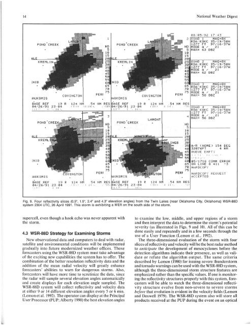
Fig. 9. Four reflectivity slices (OS, 1S, 2.4° and 4.3° elevation angles) from the Twin Lakes (near Oklahoma City, Oklahoma) WSR-88D<br />
system 2304 UTC, 26 April 1991. This storm is exhibiting a WER on the south side of the storm.<br />
supercell, even though a hook echo was never apparent with<br />
the storm.<br />
4.3 WSR-88D Strategy for Examining Storms<br />
New observational data and computers to deal with radar,<br />
satellite and environmental conditions will be implemented<br />
gradually into future modernized weather offices. Those<br />
forecasters using the WSR-88D system must take advantage<br />
of the exciting new capabilities the system has to offer. The<br />
combination of the better resolution reflectivity data and the<br />
addition of the mean radial velocity will greatly enhance<br />
forecasters ' abilities to warn for dangerous storms. Also,<br />
forecasters will have more time to scrutinize the data, since<br />
the radar will sample several elevation angles automatically<br />
and create displays for each elevation angle sampled. The<br />
WSR-88D system will collect reflectivity and velocity data<br />
at either 9 or 14 different elevation angles every 5 or 6 min.<br />
(Lemon et al. 1992). The operator can display at the Principal<br />
User Processor (PU P; Alberty 1990) the best elevation angles<br />
to examine the low, middle, and upper regions of a storm<br />
and then interpret the data to determine the storm's potential<br />
severity (as illustrated in Figs. 9 and 10). All of this can be<br />
done easily and repeatedly and in a few seconds through the<br />
use of a User Function (Lemon et aI., 1992).<br />
The three-dimensional evaluation of the storm with four<br />
slices of reflectivity and velocity will be the best radar method<br />
to anticipate the development of mesocyclones before the<br />
detection algorithms indicate their presence, as well as validate<br />
or refute the algorithm output. The same criteria<br />
described by Lemon (1980) for issuing severe thunderstorm<br />
and tornado warnings can be used with the WSR-88D system,<br />
although the three-dimensional storm structure features are<br />
emphasized rather than the specific values. If one is monitoring<br />
the reflectivity structures properly with this system, forecasters<br />
will be able to watch the three-dimensional reflectivity<br />
structure evolve from non-severe to severe storms<br />
before that evolution is evident in the velocity fields (Lemon<br />
and Doswell 1979). The WSR-88D system also will store all<br />
products received at the PUP during the event on an optical


