

ON THE NEED FOR VOLUMETRIC RADAR DATA WHEN ISSUING ...
ON THE NEED FOR VOLUMETRIC RADAR DATA WHEN ISSUING ...
ON THE NEED FOR VOLUMETRIC RADAR DATA WHEN ISSUING ...

Create successful ePaper yourself
Turn your PDF publications into a flip-book with our unique Google optimized e-Paper software.
Volume 17 Number 4 November, 1992 15<br />
'38 .' 05.' 92 18 ' 04<br />
NO<br />
.. 5<br />
10<br />
15<br />
20~~~~ __ ~~~u-_<br />
'.,.' 25<br />
i 30<br />
35<br />
40<br />
45<br />
5<br />
5<br />
6~.~~~--~~~~-<br />
65<br />
70<br />
75<br />
IT<br />
BASE REF 19 R 124 NM<br />
04 / 26 / 91 23 ; 28 'i'l I .<br />
I : " ! I I I<br />
19 R 124 NM . 54<br />
23'28 11111· :',,"", 1, I<br />
" 1. 11 I, RDA 'KOKC<br />
~~~--~~----~r-~~--------------------~1277 FT<br />
110DE A / 21<br />
4 MAX= 59 DBZ<br />
LAM<strong>ON</strong>T<br />
NO<br />
PO N C A C 11 5 L-______________ _<br />
10<br />
15<br />
20<br />
, 25<br />
30<br />
, 35 A/R (HOME) 40 DEG<br />
40 8967FT 4 NM<br />
45 OUEUE EI'lF'TY<br />
50 1 ' I> I "'. I· F" ['11 11 r<br />
55<br />
1 60 05/1801 HARDCOPY<br />
65 OUT OF PAPER<br />
70 HAF.:DCOP' ....<br />
75<br />
HARDCOPY REQUE~; T<br />
ACCEPTED<br />
RES<br />
"· t ll !<br />
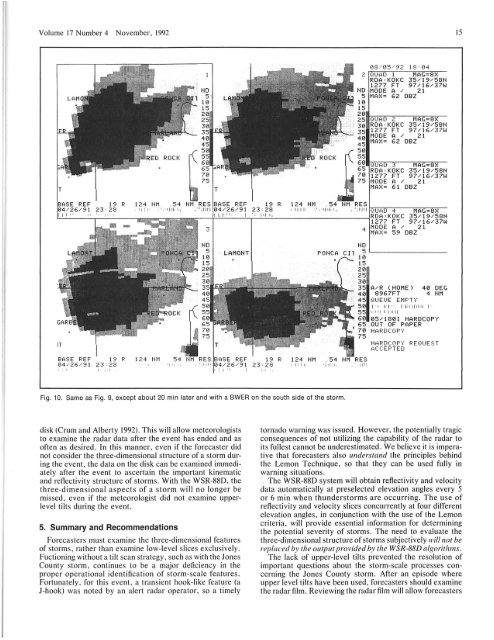
Fig, 10. Same as Fig. 9, except about 20 min later and with a BWER on the south side of the storm.<br />
disk (Crum and Alberty 1992). This will allow meteorologists<br />
to examine the radar data after the event has ended and as<br />
often as desired. In this manner, even if the forecaster did<br />
not consider the three-dimensional structure of a storm during<br />
the event, the data on the disk can be examined immediately<br />
after the event to ascertain the important kinematic<br />
and reflectivity structure of storms. With the WSR-880, the<br />
three-dimensional aspects of a storm will no longer be<br />
missed, even if the meteorologist did not examine upperlevel<br />
tilts during the event.<br />
5. Summary and Recommendations<br />
Forecasters must examine the three-dimensional features<br />
of storms, rather than examine low-level slices exclusively.<br />
Fuctioning without a tilt scan strategy, such as with the lones<br />
County storm, continues to be a major deficiency in the<br />
proper operational identification of storm-scale features .<br />
Fortunately, for this event, a transient hook-like feature (a<br />
l-hook) was noted by an alert radar operator, so a timely<br />
tornado warning was issued. However, the potentially tragic<br />
consequences of not utilizing the capability of the radar to<br />
its fullest cannot be underestimated. We believe it is imperative<br />
that forecasters also understand the principles behind<br />
the Lemon Technique, so that they can be used fully in<br />
warning situations.<br />
The WSR-880 system will obtain reflectivity and velocity<br />
data automatically at preselected elevation angles every 5<br />
or 6 min when thunderstorms are occurring. The use of<br />
reflectivity and velocity slices concurrently at four different<br />
elevation angles, in conjunction with the use of the Lemon<br />
criteria, will provide essential information for determining<br />
the potential severity of storms. The need to evaluate the<br />
three-dimensional structure of storms subjectively will not be<br />
replaced by the output provided by the WSR-88D algorithms.<br />
The lack of upper-level tilts prevented the resolution of<br />
important questions about the storm-scale processes concerning<br />
the lones County storm. After an episode where<br />
upper level tilts have been used, forecasters should examine<br />
the radar film. Reviewing the radar film will allow forecasters


