

ON THE NEED FOR VOLUMETRIC RADAR DATA WHEN ISSUING ...
ON THE NEED FOR VOLUMETRIC RADAR DATA WHEN ISSUING ...
ON THE NEED FOR VOLUMETRIC RADAR DATA WHEN ISSUING ...

Create successful ePaper yourself
Turn your PDF publications into a flip-book with our unique Google optimized e-Paper software.
Volume 17 Number 4 November, 1992 7<br />
100~--~~--~----~~--~--~~--~----~ 53<br />
50<br />
\<br />
\<br />
\<br />
\<br />
\<br />
\<br />
, ,,,<br />
24 "" 40<br />
, "<br />
, "<br />
, '<br />
,<br />
35<br />
\<br />
\<br />
\<br />
\<br />
300<br />
\\\<br />
,<br />
, , , , , , ,<br />
30<br />
, , , ,<br />
"<br />
/<br />
25<br />
500<br />
700<br />
800<br />
900<br />
1000<br />
1050<br />
/<br />
/<br />
/<br />
.4<br />
/<br />
/<br />
20<br />
18<br />
16<br />
14<br />
12<br />
8<br />
4<br />
o<br />
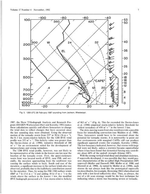
Fig. 5. 1200 UTe 28 February 1987 sounding from Jackson, Mississippi.<br />
1987, the Skew T/Hodograph Analysis and Research Program<br />
(SHARP) Workstation (Hart and Korotky 1991) makes<br />
these calculations quickly and allows forecasters to change<br />
the wind data to reflect changes that have occurred since<br />
the last sounding data were obtained. U sing the observed<br />
motion of the tornadic storm from 225 0<br />
at 50 kt (26 m s -I),<br />
the 0-3 km storm-relative he Ii city for the 1200 BVE wind<br />
profile was 352 m~ s-~. This helicity value was greater than<br />
the Davies-Jones et aI. (1990). tentative threshold of 300<br />
m~ s -~ for an environment suited for the development of<br />
mesocyclones and strong tornadoes.<br />
The 1200 BVE wind profile, however, was not likely to<br />
be representative of the winds in the lowest one km near the<br />
location of the tornadic event. First, the quasi-stationary<br />
warm front was located north of BVE, near PIB, and secondly,<br />
the mesolow approaching from the southwest was<br />
causing the sUlface winds to back. South and east of the<br />
mesolow, a significant increase in the slllface winds also was<br />
observed, probably due to the isallobaric contribution caused<br />
by the mesolow. Thus, by using the PIB 1500 surface winds<br />
(060 0 at 7 kt (3.6 m S - I» and adding 10 kt (5 m S - I) to the<br />
winds above the surface in the lowest I km, the modified<br />
BYE hodograph possessed a 0-3 km storm-relative helicity<br />
of 863 m~ s - ~ (Fig. 6). This far exceeded the Davies-Jones<br />
et aI. (1990) empirical storm-relative helicity threshold for<br />
violent tornadoes of 450 m~ s -~ in the lowest 3 km .<br />
The slow-moving warm front also would provide a possible<br />
focus for intensifying convection (see Maddox et al. 1980).<br />
Thus, forecasters would have to be concerned about the<br />
potential for tornadic storms. It is noteworthy to point out<br />
that environments with marginal CAPEs still can produce<br />
significant supercell events (for example, Korotky (1990».<br />
The low buoyancy indicated, however, that storms with large<br />
hail were not likely, unless a storm(s) became supercellular<br />
where it has been found that dynamical forcing may contribute<br />
about 60% of the updraft strength (Klemp 1987).<br />
With the strong vertical wind shear and abundant moisture,<br />
if supercells developed, it was possible that they would possess<br />
characteristics of the so-called High Precipitation (HP)<br />
supercell (Moller and Doswell 1988; Moller et al. 1990; and<br />
Doswell et al. 1990). As noted by Moller et aI. (1990), such<br />
storms do not always look like the prototypical supercells<br />
(as described in, for example, Browning 1963) when observed<br />
only with a low-level reflectivity slice. Thus, as always, the<br />
use of a tilt scan strategy would be the best technique for<br />
indicating when a storm was becoming severe or tornadic.


