the february 2009 fires - 2009 Victorian Bushfires Royal Commission
the february 2009 fires - 2009 Victorian Bushfires Royal Commission
the february 2009 fires - 2009 Victorian Bushfires Royal Commission

Create successful ePaper yourself
Turn your PDF publications into a flip-book with our unique Google optimized e-Paper software.
<strong>2009</strong> <strong>Victorian</strong> Bush<strong>fires</strong> <strong>Royal</strong> <strong>Commission</strong>—Interim Report<br />
1 THE FEBRUARY <strong>2009</strong> FIRES<br />
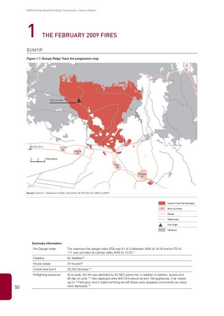
Bunyip<br />
Figure 1.7: Bunyip Ridge Track fire progression map<br />
Point of origin<br />
Nar Nar Goon<br />
Garfield<br />
Bunyip<br />
0 2 4 Kilometres<br />
Drouin<br />
Warragul<br />
Source: Exhibit 6 – Statement of Waller, Attachment 46 (WIT.002.001.0895) at 0895 96<br />
Interim Final Fire Perimeter<br />
Built Up Areas<br />
Roads<br />
Waterways<br />
Fire Origin<br />
Parkland<br />
Summary information<br />
Fire Danger Index<br />
The maximum fire danger index (FDI) was 81 at Coldstream AWS at 16:34 and an FDI of<br />
111 was recorded at Latrobe Valley AWS at 13:30. 97<br />
Fatalities No fatalities 98<br />
House losses 24 houses 99<br />
50<br />
Overall area burnt 26,200 hectares 100<br />
Firefighting resources<br />
At its peak, <strong>the</strong> fire was attended by 82 NEO personnel, in addition to tankers, dozers and<br />
68 slip-on units. 101 Also deployed were 900 CFA personnel and 159 appliances; 2 air cranes<br />
(up to 7 February); and 2 water-bombing aircraft (<strong>the</strong>se were assigned concurrently as crews<br />
were deployed). 102