the february 2009 fires - 2009 Victorian Bushfires Royal Commission
the february 2009 fires - 2009 Victorian Bushfires Royal Commission
the february 2009 fires - 2009 Victorian Bushfires Royal Commission

Create successful ePaper yourself
Turn your PDF publications into a flip-book with our unique Google optimized e-Paper software.
The February <strong>2009</strong> Fires<br />
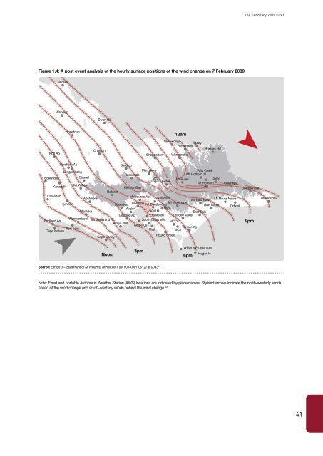
Figure 1.4: A post event analysis of <strong>the</strong> hourly surface positions of <strong>the</strong> wind change on 7 February <strong>2009</strong><br />
Mildura Mildura<br />
Robinvale<br />
Murrayville<br />
Ouyen<br />
Walpeup<br />
Swan Hill Hill<br />
Hopetoun<br />
Kerang<br />
12am<br />
Yarrawonga<br />
Albury<br />
Echuca<br />
Ru<strong>the</strong>rglen Wodonga<br />
Hunters Corryong Hill<br />
Charlton<br />
Nhill Nhill Ap<br />
Donald<br />
Shepparton Wangaratta<br />
Shepperton Wangaratta<br />
Benalla<br />
Horsham<br />
Horsham<br />
Ap<br />
Bendigo<br />
Euroa<br />
Bright<br />
Mangalore<br />
Longerenong<br />
Falls Creek<br />
Redesdale<br />
Avoca Castlemaine Seymour<br />
Mt Hotham<br />
Mansfield<br />
Edenhope Edenhope<br />
Stawell<br />
VICI<br />
Mt Buller<br />
Omeo<br />
Yea Eildon<br />
Mt Hotham Gelantipy<br />
Ararat<br />
Kanagulk<br />
Mt William<br />
Kilmore Gap<br />
Ap<br />
Combienbar<br />
Ballarat<br />
Marysville<br />
Dargo<br />
Ballarat<br />
Casterton<br />
Melbourne Ap<br />
Cann River<br />
Westmere<br />
Coldstream<br />
Orbost<br />
Mallacoota<br />
Hamilton<br />
Mt Baw Baw<br />
Mt Nowa Nowa<br />
Laverton<br />
Melbourne Mt Moornape<br />
Hamilton<br />
Bairnsdale<br />
Mallacoota<br />
Sheoakes<br />
Mt Dandenong<br />
Bairnsdale Orbost<br />
Avalon Dandenong VICF<br />
Mortlake<br />
VACH<br />
East<br />
Geelong Frankston Warragul<br />
Sale Sale<br />
Geelong Ap Frankston Latrobe Traralgon Valley<br />
Warrnambool<br />
Portland Mt Gellibrand<br />
Portland Ap<br />
Colac<br />
South Channel Is<br />
Warrnambool<br />
Anglesea<br />
VICD<br />
9pm<br />
Aireys Inlet Cowes<br />
Lorne<br />
Cerberus<br />
Port Fairy<br />
Yarram<br />
Wonthaggi<br />
Ap<br />
Cape Nelson<br />
Rhyll<br />
VICJ<br />
Apollo Bay<br />
Pound Creek<br />
Cape Otway<br />
Noon<br />
3pm<br />
Wilsons Promontory<br />
6pm<br />
Hogan Is<br />
Source: Exhibit 3 – Statement of M Williams, Annexure 1 (WIT.013.001.0012) at 0043 31<br />
Note: Fixed and portable Automatic Wea<strong>the</strong>r Station (AWS) locations are indicated by place names. Stylised arrows indicate <strong>the</strong> north-westerly winds<br />
ahead of <strong>the</strong> wind change and south-westerly winds behind <strong>the</strong> wind change. 32<br />
41