<strong>2009</strong> <strong>Victorian</strong> Bush<strong>fires</strong> <strong>Royal</strong> <strong>Commission</strong>—Interim Report 1 THE FEBRUARY <strong>2009</strong> FIRES 1.88 The first reports of casualties were received at <strong>the</strong> Kangaroo Ground Divisional Control Centre at 17:00 from <strong>the</strong> Arthurs Creek Captain. 207 The fire reached <strong>the</strong> National Park Hotel on Main Road, Kinglake at approximately 17:45. 208 The Kangaroo Ground tower had advised by radio of <strong>the</strong> wind change occurring at Kangaroo Ground at 17:43. 209 At 17:55 <strong>the</strong> tower recorded <strong>the</strong> wind change blowing at over 90 kilometres per hour and reported it to <strong>the</strong> fireground. 210 By 18:00 CFA tankers, pumpers and communications vehicles were responding to new <strong>fires</strong> at Humevale, Stra<strong>the</strong>wen, Arthurs Creek, Yarra Glen, Gruyere and Healesville. All of <strong>the</strong>se <strong>fires</strong> were caused by spotting. 211 212 1.89 At 18:01 <strong>the</strong> wind change had come through St Andrews. When <strong>the</strong> south-westerly wind change reached <strong>the</strong>se <strong>fires</strong> between 18:00 and 19:00, it was not possible to secure <strong>the</strong> eastern flank of <strong>the</strong> fire due to <strong>the</strong> heavy forest and plantation fuel loads. 213 The main fire, and <strong>the</strong> subsequent spot <strong>fires</strong>, headed in a nor<strong>the</strong>asterly direction, burning through heavy fuels. 214 At 19:40 <strong>the</strong> fire was recorded in Flowerdale. 215 The Kilmore East–Wandong section of <strong>the</strong> fire headed generally north along <strong>the</strong> Hume Highway towards Reedy Creek impacting at 20:00, burning through <strong>the</strong> remainder of <strong>the</strong> Wallaby Creek catchment, <strong>the</strong> Kinglake National Park and <strong>the</strong> Mount Disappointment Forest. 216 Progressively through <strong>the</strong> evening it impacted <strong>the</strong> settlements of Hazeldene and Silver Creek. The fire was recorded at Mudgegonga at about 22:00. 217 1.90 1.91 From Stra<strong>the</strong>wen and Humevale, <strong>the</strong> fire headed generally north, through Kinglake central, Castella and along <strong>the</strong> Melba Highway towards <strong>the</strong> settlement of Glenburn. The Kilmore East fire did not join with <strong>the</strong> Murrindindi fire on 7 February. 218 The fire was never under control on 7 February. 219 Throughout <strong>the</strong> night of 7 February, and <strong>the</strong> following days, as <strong>the</strong> fire reached grassland, it was stopped and <strong>the</strong> edge of <strong>the</strong> fire progressively secured. However, in forested areas, particularly in <strong>the</strong> Maroondah catchment, Toolangi State Forest and Yarra Ranges National Park, containment was difficult. In particular, <strong>the</strong> fire caused considerable concern around <strong>the</strong> Healesville area over <strong>the</strong> next few days as containment works, including back burning, continued. 220 The fire was listed as contained on 16 February. 221 Warnings 58 1.92 1.93 1.94 1.95 1.96 Some warning messages for <strong>the</strong> Kilmore East fire were issued from <strong>the</strong> Seymour Regional Emergency Coordination Centre (authorised by <strong>the</strong> Regional Coordinator) and from <strong>the</strong> iECC (authorised by <strong>the</strong> State Duty Officer), in addition to those issued from Kilmore ICC. 222 At 12:40 an initial awareness message was issued for <strong>the</strong> Kilmore East fire for Kilmore East, Wandong and Clonbinane. 223 Urgent threat messages were issued progressively for communities to <strong>the</strong> south-east and east of <strong>the</strong> fire, and subsequently updated as fur<strong>the</strong>r information was available. 224 At 13:59 an urgent threat message was issued for Wandong. 225 At 14:40 an urgent threat message was posted to <strong>the</strong> CFA website for <strong>the</strong> community of Wandong, and messages were progressively posted for <strong>the</strong> communities of Hidden Valley (at 15:05), Whittlesea (at 15:33), Heathcote Junction and Upper Plenty (at 16:05), Humevale, Arthurs Creek, Eden Park, Nutfield and Doreen (at 16:35) and for communities from Kinglake to Flowerdale (at 17:55). 226 At 17:20 an urgent threat message was released from Kangaroo Ground Divisional Control Centre indicating Wandong, Wallan, Wallan East, Eden Park, Whittlesea, Humevale, Bruces Creek, Upper Plenty, Kinglake West, Pheasant Creek, Smiths Gully, Kinglake, Flowerdale, Glenburn and Hurstbridge might be affected by <strong>the</strong> fire. 227 It also referred to road closures. 228 Urgent threat messages had been drafted earlier in <strong>the</strong> afternoon (from 14:30) at Kangaroo Ground Divisional Control Centre, but had not been released as <strong>the</strong> fire was being controlled from <strong>the</strong> ICC at Kilmore. 229 At 18:45, an urgent threat message posted to <strong>the</strong> CFA website noted that Wandong, Wallan, Wallan East, Eden Park, Whittlesea, Humevale, Bruces Creek, Upper Plenty, Kinglake West, Pheasant Creek, Smiths Gully, Kinglake, Flowerdale, Glenburn and Hurstbridge might be directly affected by fire. 230 As <strong>the</strong> fire continued to burn through <strong>the</strong> night, an urgent threat message was posted to <strong>the</strong> CFA website at 22:32 advising of possible direct attack on Broadford, Broadford East in <strong>the</strong> area of O’Gradys Road, south of Broadford, Broadford–Wandong/Sunday Creek Road, Reedy Creek and Tyaak. Residents were advised not to expect firefighting trucks to be in attendance if <strong>the</strong> firefront approached <strong>the</strong>ir properties. 231
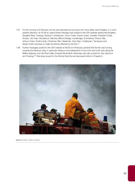
The February <strong>2009</strong> Fires 1.97 1.98 On <strong>the</strong> morning of 8 February, <strong>the</strong> fire was described as burning in <strong>the</strong> Yarra Valley near Kinglake, in a nor<strong>the</strong>asterly direction. At 04:38 an urgent threat message was posted to <strong>the</strong> CFA website stating that Kinglake, Kinglake West, Toolangi, Glenburn, Stra<strong>the</strong>wen, Chum Creek, Dixons Creek, Castella, Pheasant Creek, Doreen, Yan Yean, Woodstock, Mernda, Mittons Bridge, Hurstbridge, St Andrews, Panton Hills, Arthurs Creek, Smiths Gully, Christmas Hills, Healesville, Yarra Glen, Coldstream, Tarrawarra and Steels Creek had been or might be directly affected by this fire. 232 Fur<strong>the</strong>r messages posted to <strong>the</strong> CFA website at 09:29 on 8 February advised that <strong>the</strong> fire was burning towards <strong>the</strong> Glenburn area, in particular Glenburn and settlements to <strong>the</strong> north and north-east along <strong>the</strong> Melba Highway, and Yea River Valley towards Murrindindi. Warnings were also posted for Yea, Seymour and Toolangi. 233 Warnings issued for <strong>the</strong> Kilmore East fire are discussed fur<strong>the</strong>r in Chapter 9. Source: Pat Scala, courtesy of The Age 59