

Sacramento Surveyors Visit the NGS Airborne Gravimeter - CLSA
Sacramento Surveyors Visit the NGS Airborne Gravimeter - CLSA
Sacramento Surveyors Visit the NGS Airborne Gravimeter - CLSA

Create successful ePaper yourself
Turn your PDF publications into a flip-book with our unique Google optimized e-Paper software.
Continued from previous page<br />
Let’s talk about <strong>the</strong> data collection aspect of <strong>the</strong> GRAV-<br />
D program, which is explained in detail in <strong>the</strong> Project Plan,<br />
which can be found online: http://www.ngs.noaa.gov/<br />
GRAV-D/pubs/GRAV-D_v2007_12_19.pdf. The program<br />
has an approximate time line of 10 years which started in<br />
2008. Phase I consisted of testing parameters for flight<br />
operations, and was performed in <strong>the</strong> Gulf of Mexico,<br />
Puerto Rico and <strong>the</strong> U.S. Virgin Islands. Phase II data collection<br />
is defined by six categories of areas; Parts 1 and 2<br />
are in Alaska because <strong>the</strong> realization of NAVD 88 in <strong>the</strong><br />
state is very poor, and that effort has been started. Part 3 is<br />
“littoral zones of continental U.S.,” and California and<br />
southwestern Oregon are benefiting<br />
from this winter, 2011 operation.<br />
Flights in Alaska will likely<br />
be done between April and<br />
November, and <strong>the</strong> 2012 plan is<br />
to do <strong>the</strong> more remote western<br />
area of that state and begin<br />
working in <strong>the</strong> Great Lakes<br />
region. It is possible that <strong>the</strong> PC-<br />
12 will return next winter for<br />
flights in central and sou<strong>the</strong>rn<br />
California. At <strong>the</strong> end of January,<br />
9.78% of <strong>the</strong> area outlined in <strong>the</strong><br />
plan had been completed; <strong>the</strong><br />
goal for FY11 (end of September)<br />
is 13%, and for FY12, it is 20%.<br />
The annual budget is currently<br />
about $3.0 million per year. The<br />
projected budget in <strong>the</strong> Plan was<br />
nearly $40 million, so at this rate,<br />
it does appear that it will take<br />
until 2022 before Part A, The<br />
High Resolution Snapshot, is<br />
completed.<br />
Getting Results<br />
Vicki explains <strong>the</strong> time frame for getting results in areas<br />
that have been flown: “Since we have been developing our<br />
software tools at <strong>the</strong> same time as conducting field operations,<br />
getting <strong>the</strong> whole data processing component up and<br />
running has been challenging. We've now caught up with<br />
all of our backlog on <strong>the</strong> kinematic GPS processing (<strong>the</strong><br />
first step in <strong>the</strong> procedure) and expect to complete <strong>the</strong><br />
gravity processing in March for our first finalized data<br />
release of <strong>the</strong> Gulf of Mexico data. The program started<br />
with just me as Program Manager, and after three years,<br />
now includes eight full-time and four part-time staff.<br />
Ultimately, we expect to process data in a one-to-one relationship<br />
between collection time and processing time,<br />
although we're not <strong>the</strong>re yet. I expect that pretty soon we'll<br />
be looking at about a three to four month turn-around time<br />
from <strong>the</strong> end of a survey until <strong>the</strong> production of a final airborne<br />
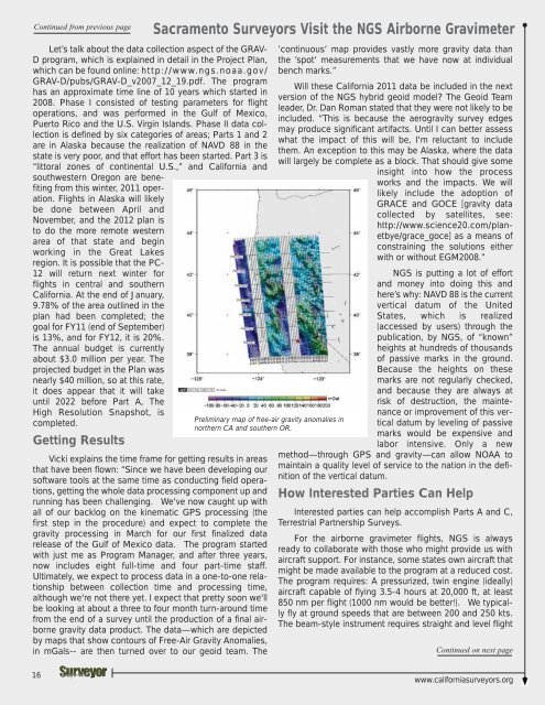
gravity data product. The data—which are depicted<br />
by maps that show contours of Free-Air Gravity Anomalies,<br />
in mGals-- are <strong>the</strong>n turned over to our geoid team. The<br />
<strong>Sacramento</strong> <strong>Surveyors</strong> <strong>Visit</strong> <strong>the</strong> <strong>NGS</strong> <strong>Airborne</strong> <strong>Gravimeter</strong><br />
Preliminary map of free-air gravity anomalies in<br />
nor<strong>the</strong>rn CA and sou<strong>the</strong>rn OR.<br />
’continuous‘ map provides vastly more gravity data than<br />
<strong>the</strong> ’spot‘ measurements that we have now at individual<br />
bench marks.”<br />
Will <strong>the</strong>se California 2011 data be included in <strong>the</strong> next<br />
version of <strong>the</strong> <strong>NGS</strong> hybrid geoid model? The Geoid Team<br />
leader, Dr. Dan Roman stated that <strong>the</strong>y were not likely to be<br />
included. “This is because <strong>the</strong> aerogravity survey edges<br />
may produce significant artifacts. Until I can better assess<br />
what <strong>the</strong> impact of this will be, I'm reluctant to include<br />
<strong>the</strong>m. An exception to this may be Alaska, where <strong>the</strong> data<br />
will largely be complete as a block. That should give some<br />
insight into how <strong>the</strong> process<br />
works and <strong>the</strong> impacts. We will<br />
likely include <strong>the</strong> adoption of<br />
GRACE and GOCE [gravity data<br />
collected by satellites, see:<br />
http://www.science20.com/planetbye/grace_goce]<br />
as a means of<br />
constraining <strong>the</strong> solutions ei<strong>the</strong>r<br />
with or without EGM2008.”<br />
<strong>NGS</strong> is putting a lot of effort<br />
and money into doing this and<br />
here’s why: NAVD 88 is <strong>the</strong> current<br />
vertical datum of <strong>the</strong> United<br />
States, which is realized<br />
(accessed by users) through <strong>the</strong><br />
publication, by <strong>NGS</strong>, of “known”<br />
heights at hundreds of thousands<br />
of passive marks in <strong>the</strong> ground.<br />
Because <strong>the</strong> heights on <strong>the</strong>se<br />
marks are not regularly checked,<br />
and because <strong>the</strong>y are always at<br />
risk of destruction, <strong>the</strong> maintenance<br />
or improvement of this vertical<br />
datum by leveling of passive<br />
marks would be expensive and<br />
labor intensive. Only a new<br />
method—through GPS and gravity—can allow NOAA to<br />
maintain a quality level of service to <strong>the</strong> nation in <strong>the</strong> definition<br />
of <strong>the</strong> vertical datum.<br />
How Interested Parties Can Help<br />
Interested parties can help accomplish Parts A and C,<br />
Terrestrial Partnership Surveys.<br />
For <strong>the</strong> airborne gravimeter flights, <strong>NGS</strong> is always<br />
ready to collaborate with those who might provide us with<br />
aircraft support. For instance, some states own aircraft that<br />
might be made available to <strong>the</strong> program at a reduced cost.<br />
The program requires: A pressurized, twin engine (ideally)<br />
aircraft capable of flying 3.5-4 hours at 20,000 ft, at least<br />
850 nm per flight (1000 nm would be better!). We typically<br />
fly at ground speeds that are between 200 and 250 kts.<br />
The beam-style instrument requires straight and level flight<br />
Continued on next page<br />
16<br />
www.californiasurveyors.org


