

Sacramento Surveyors Visit the NGS Airborne Gravimeter - CLSA
Sacramento Surveyors Visit the NGS Airborne Gravimeter - CLSA
Sacramento Surveyors Visit the NGS Airborne Gravimeter - CLSA

Create successful ePaper yourself
Turn your PDF publications into a flip-book with our unique Google optimized e-Paper software.
Continued from previous page<br />
in conditions of no-to-low turbulence. A well-functioning<br />
autopilot is a necessity. For ground work, measurements<br />
made with relative gravity meters, or by dual-frequency<br />
GPS equipment, at leveled bench marks might contribute<br />
to improvements in <strong>the</strong> vertical datum. For <strong>the</strong> latter, we<br />
would want four or more hours of data submitted to OPUS<br />
and published in that database so <strong>the</strong> observations could<br />
be available to <strong>the</strong> geoid modeling effort. We could fill in <strong>the</strong><br />
‘gaps’ which are defined as being 20-30 km from a geometric/leveled<br />
mark that was already used in GEOID09. The<br />
spreadsheet and map of those marks can be found at <strong>the</strong><br />
“Outreach” tab on <strong>the</strong> CGAR webpage:<br />
http://www.dot.ca.gov/hq/row/landsurveys/geodetic/Outreach/outreach.html.<br />
If interested parties have a specific<br />
area of interest, <strong>the</strong> Geodetic Advisor can<br />
provide more detailed advice about choosing<br />
a bench mark where GPS data observation<br />
(ellipsoid height) would help.<br />
Turbulence Scrubs <strong>the</strong> Flight<br />
So, going back to <strong>the</strong> activities of<br />
February 5, 2011, we all got to go out to<br />
<strong>the</strong> plane and squeeze through, a few people<br />
at a time, to look at <strong>the</strong> setup, as Justin explained <strong>the</strong><br />
graphics on <strong>the</strong> screen. Because of <strong>the</strong> flight scheduled for<br />
liftoff at 8:30 a.m., we were off <strong>the</strong> tarmac by 8:00 a.m. and<br />
reconvened in <strong>the</strong> passenger lounge. Marti provided information<br />
about <strong>the</strong> GRAV-D program and showed maps of<br />
locations where operations have been completed or are<br />
planned. Justin joined us shortly and explained that <strong>the</strong><br />
day’s flight had been scrubbed because turbulence was<br />
expected. Sure enough, <strong>the</strong> calm conditions of <strong>the</strong> early<br />
morning turned into windy, gusty conditions that afternoon.<br />
Everyone was appreciative that <strong>NGS</strong> provided an opportunity<br />
for a close-up look at this aspect of <strong>the</strong> airborne gravity<br />
data collection effort which will move us closer to a better<br />
realization of <strong>the</strong> vertical reference system. <br />
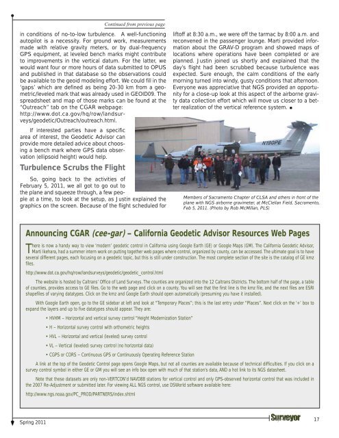
Members of <strong>Sacramento</strong> Chapter of <strong>CLSA</strong> and o<strong>the</strong>rs in front of <strong>the</strong><br />
plane with <strong>NGS</strong> airborne gravimeter, at McClellan Field, <strong>Sacramento</strong>,<br />
Feb 5, 2011. (Photo by Rob McMillan, PLS)<br />
Announcing CGAR (cee-gar) – California Geodetic Advisor Resources Web Pages<br />
There is now a handy way to view ‘modern’ geodetic control in California using Google Earth (GE) or Google Maps (GM). The California Geodetic Advisor,<br />
Marti Ikehara, had a summer intern work on putting toge<strong>the</strong>r web pages where control, organized by county, can be accessed. The ultimate goal is to have<br />
several different pages, each focusing on a geodetic topic, but this is still under construction. The most complete section of <strong>the</strong> site is <strong>the</strong> catalog of GE kmz<br />
files.<br />
http://www.dot.ca.gov/hq/row/landsurveys/geodetic/geodetic_control.html<br />
The website is hosted by Caltrans’ Office of Land Surveys. The counties are organized into <strong>the</strong> 12 Caltrans Districts. The bottom half of <strong>the</strong> page, a table<br />
of counties, provides access to GE files. Go to <strong>the</strong> web page and click on a county. You will see that <strong>the</strong> first line is <strong>the</strong> kmz file, and <strong>the</strong> next files are ESRI<br />
shapefiles of varying datatypes. Click on <strong>the</strong> kmz and Google Earth should open automatically (presuming you have it installed).<br />
With Google Earth open, go to <strong>the</strong> GE sidebar at left and look at “Temporary Places”; this is <strong>the</strong> last entry under “Places”. Next click on <strong>the</strong> ‘+’ box to<br />
expand <strong>the</strong> layers and up to five datatypes should appear. They are:<br />
• HVHM – Horizontal and vertical survey control “Height Modernization Station”<br />
• H – Horizontal survey control with orthometric heights<br />
• HVL – Horizontal and vertical (leveled) survey control<br />
• VL – Vertical (leveled) survey control (no horizontal data)<br />
• CGPS or CORS – Continuous GPS or Continuously Operating Reference Station<br />
A link at <strong>the</strong> top of <strong>the</strong> Geodetic Control page opens Google Maps, but not all counties are available because of technical difficulties. If you click on a<br />
survey control symbol in ei<strong>the</strong>r GE or GM you will see an info box open with much of that station’s data, AND a hot link to its <strong>NGS</strong> datasheet.<br />
Note that <strong>the</strong>se datasets are only non-VERTCON’d NAVD88 stations for vertical control and only GPS-observed horizontal control that was included in<br />
<strong>the</strong> 2007 Re-Adjustment or submitted later. For viewing ALL <strong>NGS</strong> control, use DSWorld software available here:<br />
http://www.ngs.noaa.gov/PC_PROD/PARTNERS/index.shtml<br />
Spring 2011<br />
17


